Welcome to Geotech!

Sharing of Geophysical Method Application Technology Part 2
This sharing mainly focuses on the second of the “three treasures of geophysical exploration”, ground penetrating radar and induction electromagnetic method, and introduces them from the perspective of application direction and past successful cases. The content is as follows:
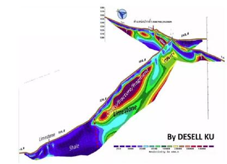
1. Resistivity method plays an important role in cave exploration and rescue
The resistivity method is widely used in finding faults and caves. During the Thailand cave rescue operation, our electrical equipment successfully measured the location of the cave in the mountain, providing the rescue team with valuable guidance information and facilitating the smooth progress of the rescue operation.
2. Survey results of sediment sediments in the Yangtze River reservoir
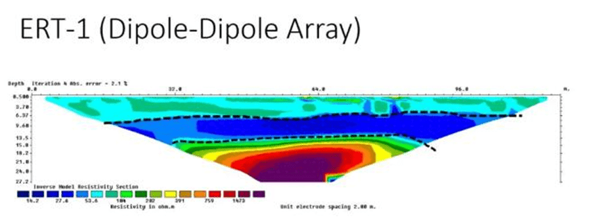
In a reservoir on the Yangtze River, our measuring equipment clearly shows the water body, sediment deposition and bedrock. After depth correction, the measurement results are highly consistent with the actual results. Since the reservoir is a source of drinking water, the sedimentation is relatively stable and the tomography effect is obvious. At the same time, the instrument is encrypted when collecting data, and the data volume is large, which further improves the tomography effect.
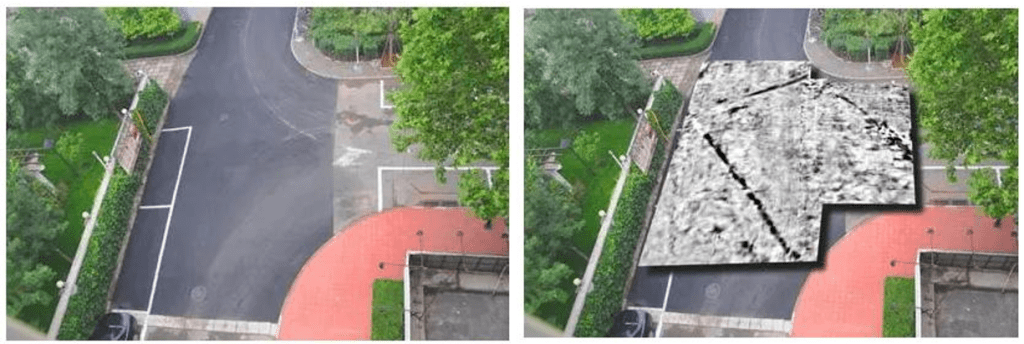
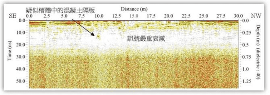
3. Ground Penetrating Radar
Ground Penetration Radar (GPR) plays a key role in detecting the direction of pipelines below the T-junction.
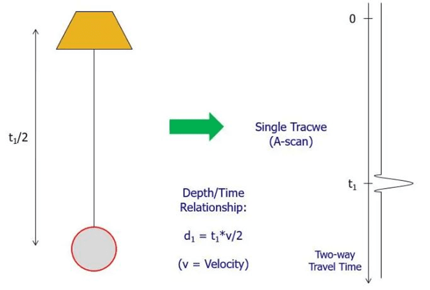
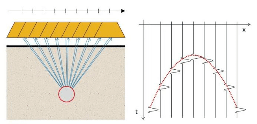
Principle of Ground Penetrating Radar
The working principle of ground penetrating radar is to use a transmitter on the ground to transmit an electromagnetic signal of a specific frequency vertically underground, and then receive the reflected signal through a receiver. When the signal encounters an underlying interface with a different dielectric constant, it will be reflected back, and the system calculates the depth of the interface by measuring the incident and reflection time of the signal.
In practical applications, it is necessary to balance the problem of depth measurement and accuracy. High-frequency signals have high resolution, but are easily absorbed by the strata and have limited depth measurement; low-frequency signals have low resolution, but can measure deeper. Geophysical experts often need to make a trade-off between depth and accuracy when choosing a method.
Ground penetrating radar is widely used in the construction and surveying industry, such as locating underground pipelines and structures, measuring the layout of steel bars in concrete, etc. Commonly used frequencies are 200MHz, 450MHz and 700MHz. The theoretical measurement depths of different frequencies are also different. The measurement depth of 200MHz is 15-20 meters, 450MHz is 5-10 meters, and 700MHz can only measure within one meter. In actual sites, useful signals are usually shallower. Taking the commonly used 450MHz antenna as an example, usually only data within 5 meters is used.
Two-dimensional radar and three-dimensional radar
2D radar can only view forward and backward in the direction of travel, while 3D radar can view in all directions, front and back, left and right, providing more complete information. Ground penetrating radar is widely used in the engineering survey industry and has a lot of experience.
In the field of soil pollution investigation, we study and use this method more. In organic pollution sites, if the ground is relatively flat, we will first use radar to measure several sections to find out the distribution of suspected pollution areas, and then use the resistivity method to further obtain detailed information to verify each other.
Through radar methods, we can see the surface steel mesh, buried pipelines and suspected contaminated areas. When the soil layer is contaminated by hydrocarbon media, its dielectric constant will change, forming a large contrast with the surrounding layers, and thus be detected by radar.
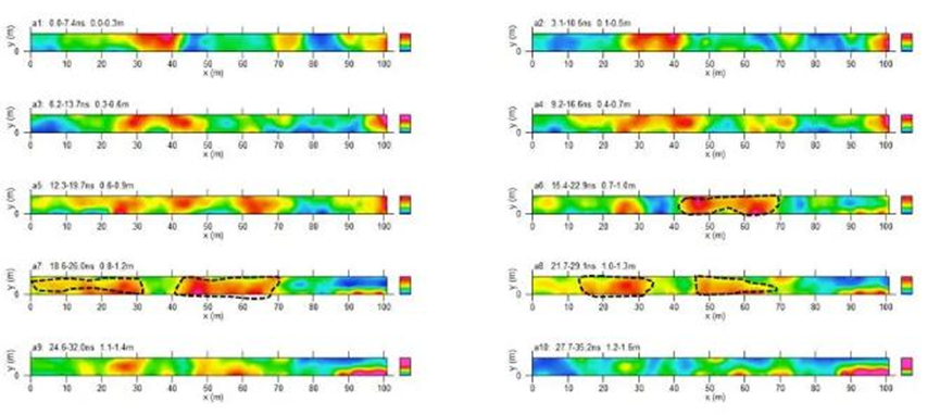
In some special heavy metal contaminated sites, the limitations of radar methods can also be used to achieve detection purposes. For example, in an oil leak investigation at a chemical plant, we produced horizontal slices and successfully identified areas where anomalies might occur. The anomalies mainly started at one meter and gradually narrowed with increasing depth.
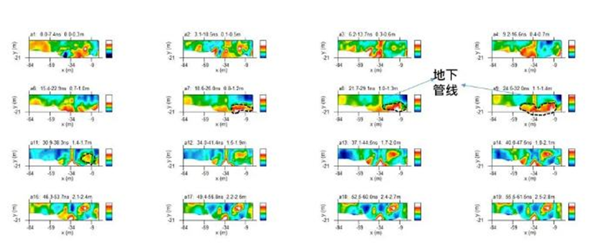
In another area, we cut 20 equal depth planes and found a pipeline running from north to south, buried about one meter deep, at a horizontal position of -34. It is speculated that the pollution is mainly bounded by this pipeline, with pollution appearing to the east and no obvious abnormality to the west. The pollution depth exceeds 1.5 meters.
At present, we use radar + resistivity method to investigate underground leakage pollution in production enterprises, and the effect is good. While finding pollution, we can also find the pipelines that are secretly buried and discharged by enterprises, and assist investigation and law enforcement units in collecting evidence, with a high success rate.
For example, in a plating plant park that is accessed by a highway, there are pipes of varying diameters buried underground, made of PVC, and irritating gases can be smelled outside the park. We used radar and resistivity methods to identify suspected contaminated areas and drilled holes to take samples for inspection and analysis.
4. Induction Electromagnetic Method
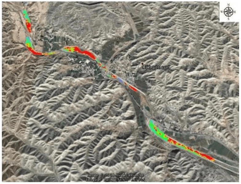
In the distribution map of heavy metal pollution measured in a river, the red part represents the high conductivity area, that is, the heavy metal distribution area. This is the measurement result of the induction electromagnetic method.
Principle of induction electromagnetic method
Induction electromagnetic method, also known as frequency domain electromagnetic method (FDEM), generates an induced magnetic field in the formation through the instantaneous current of the coil, and records the phase difference of the secondary magnetic field to calculate the apparent conductivity of the material. When the frequency and coil distance are fixed , the two- dimensional tangent plane distribution of the conductivity of the material at a specific depth can be depicted .
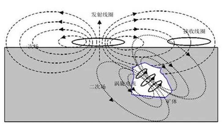
Its theoretical basis is Lenz’s law, which is similar to the principle of microwave ovens.
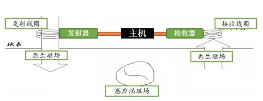
The induction electromagnetic method is easy to operate. The operator can complete the measurement by carrying the equipment and walking back and forth at regular intervals at the measurement site. Therefore, the measurement efficiency is very high. Since the collected data is in the frequency domain, it does not need to be inverted and can be directly mapped, which is very intuitive.
However, this method has certain requirements for the test environment and is sensitive to electromagnetic and metal interference. Before measurement, it is necessary to eliminate interference sources such as microwave towers, high-voltage lines, and metal fences near the site.
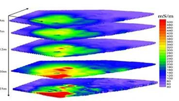
In an abandoned battery factory, multi-frequency signal measurement revealed a large amount of metal waste buried at a depth of 10 to 25 meters .
For heavy metal contaminated sites, if environmental conditions permit, priority will be given to using induction electromagnetic scanning. After determining the high-conductivity anomaly area, the resistivity method will be used for vertical section measurements.
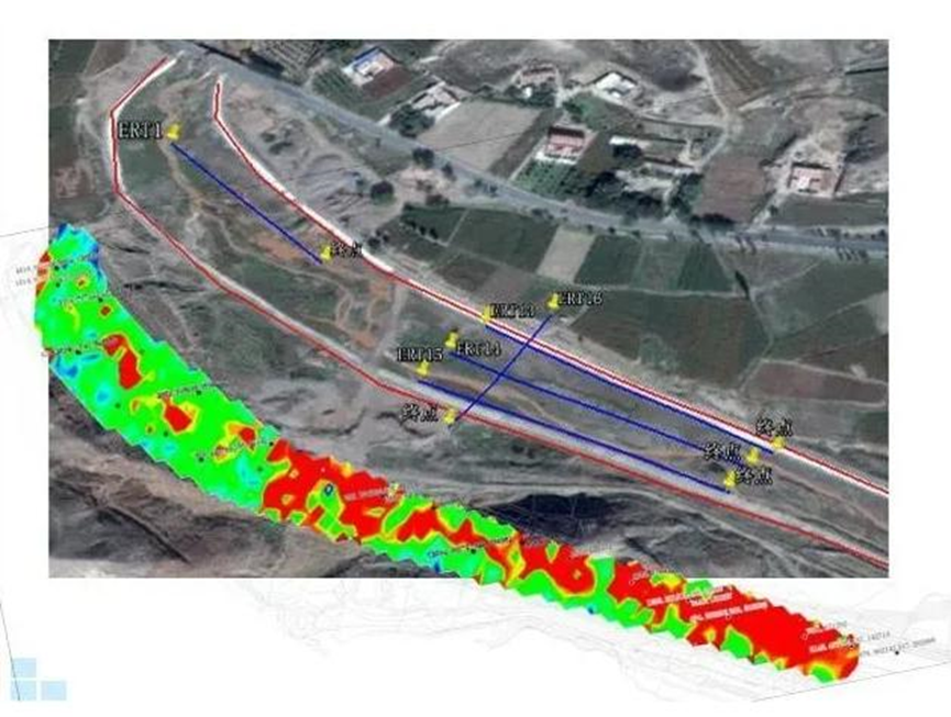
Taking a section of the river as an example, the results of the induction electromagnetic method showed high conductivity anomaly areas. In these areas, we selected four resistivity survey lines, three rows and one vertical line.
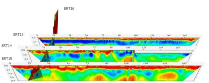
ERT stands for resistivity and EM stands for conductivity, and the two are inversely proportional to each other. The resistivity survey line not only confirms the results of the induction electromagnetic method, but also provides depth distribution information. The combination of the two methods can determine the three-dimensional spatial range of the distribution of heavy metal pollution in the river.
Induction electromagnetic method is mostly used for heavy metal contaminated sites, but in some cases it can also be used for large-scale organic contaminated site surveys. Organic pollutants will show low conductivity (i.e. high resistance) anomalies relative to the background strata.
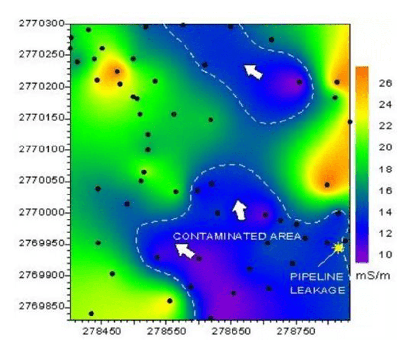
In one case, the results of the induction electromagnetic method determined the area of contamination caused by an oil leak caused by a pipeline rupture.