Welcome to Geotech!

How to improve the success rate of well drilling?
I. Understand the formation of groundwater, understand the local topography and landforms, and look at the mountain shape and terrain
1. There are three main aspects of groundwater
The first is the source of water supply, such as rainfall, rainfall temporal and spatial distribution, river and lake conditions, etc.;
The second is the surface infiltration conditions, for example, sandy land has better infiltration conditions than clay land, and limestone areas have better infiltration conditions than granite areas;
The third is the underground water storage capacity, including the porosity, fissures, and groundwater burial depth of the aquifer. Affected by natural conditions, geological structure, water storage capacity and other factors, there are large regional differences in my country’s groundwater production capacity.
2. Formation of groundwater
Groundwater mainly comes from atmospheric precipitation and infiltration of surface water; it also replenishes rivers, lakes and swamps by underground seepage, or directly injects into the ocean; the water in the upper soil evaporates or is absorbed by plant roots and then dissipates into the air, returning to the atmosphere, thus actively participating in the water cycle on the earth, as well as the processes of dissolution, landslide, soil salinization, etc. that occur on the earth.
No matter what the reason for the formation of groundwater is, groundwater shows good conductivity and low resistance in geophysical exploration. Therefore, the current method of finding groundwater in the world is electrical water finder.
II. Choose the right water finder for you
The purpose of water finder is to find water by drilling wells. It is hoped that before drilling wells, it can accurately detect whether there is water underground, and find the location, depth, flow direction, etc. of groundwater. Geotech has a variety of instrument solutions, including electrical equipment, magnetic equipment, seismic equipment, etc., to solve the multi-solution of geophysical exploration and improve the success rate of drilling wells.
Geophysical exploration methods may be affected by groundwater (groundwater has similar physical properties to ore, low resistance and high excitation), low resistance anomalies formed by different benign conductive low-resistance geological bodies and surrounding rocks, and other interference factors in actual detection.
Solution: Multi-parameter, multi-instrument, combined with professional management, multiple data collection and comprehensive analysis to judge.
III. Accurate field data collection and measurement
Measurement precautions, measure more known wells, and accumulate experience through experiments.
When measuring on a hillside, try to choose the same altitude for layout to reduce the impact of terrain on the measurement results. If it is not possible to lay out at the same altitude, try to choose a direction with consistent or gentle slope, and the height difference between adjacent points should not exceed 2 meters.
The survey line should be as far away from high-voltage transmission lines and telephone lines as possible to avoid the impact of electromagnetic interference on the measurement results. If it is not possible to stay away from these facilities, the wiring direction should be as parallel to them as possible.
When measuring, try to ensure that the M and N electrodes are on the same plane, and the recording point should be the center point of the M and N electrodes or below the equipment sensor to ensure the accuracy of the measurement results.
In the same survey area, the point distance and line distance should be kept consistent as much as possible to facilitate data recording and analysis. This can not only improve work efficiency, but also reduce errors in data processing.
1. Straight profile
● Scope of application: Applicable to most areas of measurement, the most commonly used wiring measurement method, suitable for detecting various types of groundwater and other targets;
● Laying method: According to the changes in the topography and terrain on site, the survey line should be as vertical as possible to the direction of the abnormal body to ensure that the structural changes of groundwater can be effectively detected. The straight profile should be kept as straight as possible, and as many measuring points as possible should be set. The distance between the measuring points is generally greater than or equal to 2-3 times the width of the detected target. The water-bearing area of the third and fourth system interstitial water in general areas is generally large, so it is generally appropriate to measure the profile length of more than 10 to 30 points, and the point distance is kept at 2-5 meters. Single-channel equidistant mobile measurement to complete the straight profile, multi-channel can be arranged into a straight line measurement once or multiple times to complete the straight profile measurement, and the same measurement is used when using the probe.
● Features: Simple operation, a common method for field wiring, can quickly determine the location and depth of the target;
● Key points: The straight line laid out is as straight as possible, and can be cut straight at different elevations or the same elevation. You can use a tape measure and spray paint to mark the measuring points; the number of measuring points should not be too small, it is recommended to be more than 5 times the width of the groundwater (abnormal body), or 14 points to more than 30 points, to increase the success rate of finding water and drilling wells.

Use a tape measure or the three-point method using a compass or a pole to determine the straightness of the line.
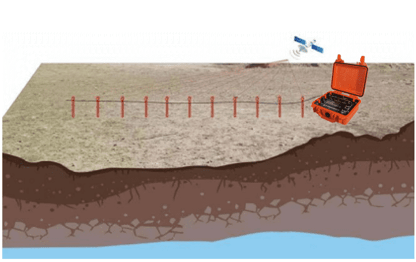
The profile should be as long as possible, with as many measuring points as possible, and the water search should be more accurate
2. Multi-profile-plane profile
● Scope of application: Applicable to areas that require high water search accuracy, have little information about the target, and are completely unclear about the direction of the exploration target
● Layout method: Lay out multiple parallel and equally spaced straight profiles, generally requiring 3 or more, and the point distance and line distance should be accurate to determine the direction and depth of the abnormal body. For geophysical exploration, the profile length is 3-10 times that of the target. Generally, 14 measuring points are required on each survey line, and the point distance is at least two meters;
● Features: After locating the position of purple-blue (groundwater), it may not necessarily be groundwater. We need to understand the direction of groundwater flow recharge to determine whether it is a low-resistance layer or groundwater-generated purple-blue. And some small fissure water can be found. The fissure water is small and difficult to find in one profile. It is necessary to measure more than 3 parallel profiles to analyze the location and flow direction of groundwater to improve the success rate of well drilling. In addition, for multi-profile analysis of the area, the instrument’s built-in data reconstruction function can be used to draw plan profiles at different depths and analyze the planar orientation of the anomaly and the direction of groundwater recharge.
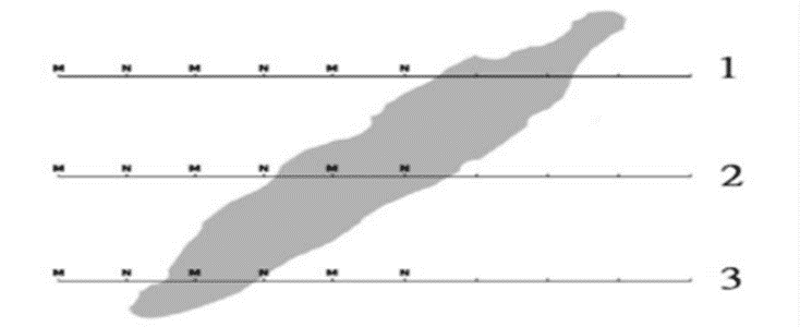
Multi-section measurement is more accurate
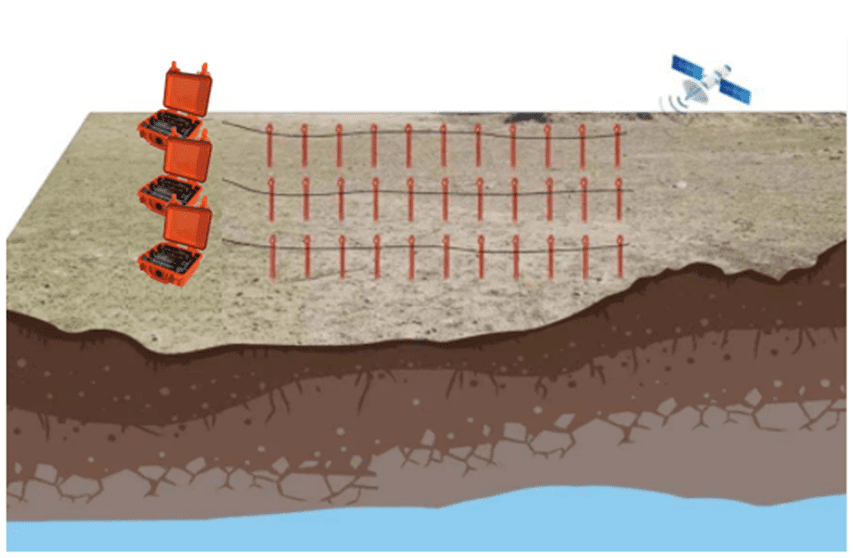
Good effect on judging the direction of water flow replenishment and fissure water
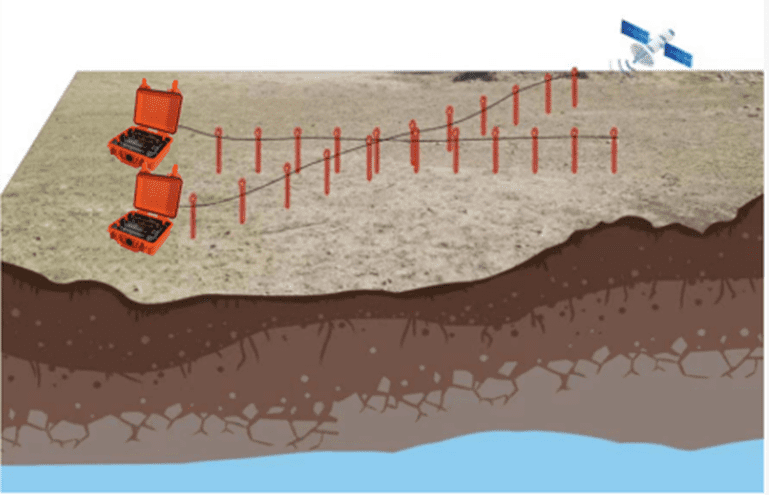
3. Cross-section
● Scope of application: Applicable to areas with relatively limited sites that are not suitable for the layout of “multi-section plane section”, but need to improve the success rate, have less known information, and are completely unclear about the direction of the exploration target. It can be simply understood as “simple multi-section measurement”. In principle, no plane section diagram is drawn;
● Layout method: First complete a straight line section measurement. After the measurement is completed, you can rotate 45-90° clockwise (counterclockwise) to measure the second straight line section. The two cross-sections or oblique cross-sections are used to analyze the direction of the abnormal body to determine the well drilling position to improve the success rate;
● Features: Combining two straight line sections can repeatedly confirm the existence of the exploration target, and can also assist in determining the general direction of the exploration target, improving the success rate of well drilling.

4. Circular profile
● Applicable area: A special wiring method, generally used in areas where there are point interference sources such as transformers and signal towers nearby. In this profile measurement, the interference is adjusted to be consistent to remove the interference;
● Laying out method: A circular or semicircular profile is laid out with the interference object as the center for measurement. The size of the circle is generally set according to the size of the interference source. Generally, the greater the interference, the larger the radius of the circle, and the farther away from the interference source;
● Features: It can effectively reduce interference and quickly trace the direction and position of the target object.
【Intelligent exploration equipment recommendation】
Unlock New Heights in Geophysical Exploration: Geotech GIM Series High-Density Resistivity and IP Testing System
As a leading multi-functional electrical exploration device, the GIM Series integrates natural potential measurement, 1D/2D/3D resistivity imaging (ERT), and induced polarization (IP) capabilities. With 24-bit high-precision A/D conversion and bi-directional cascading technology, it breaks traditional electrical exploration depth limitations, achieving 1,500-meter penetration. The IP67 waterproof design and wide operating temperature range of -20°C to +60°C ensure stable performance in extreme environments.
Key Advantages
✅ Multi-Scenario Adaptability: From groundwater pollution monitoring to ore body location, it supports cross-hole, underwater, and 3D distributed cabling.
✅ Intelligent Efficiency Boost: 10-channel synchronous acquisition + rolling measurement mode captures multi-electrode data in a single setup.
✅ Data Compatibility: Exports TXT/Excel formats compatible with mainstream inversion software (Res2DInv, EarthImager).

Discover How the GIM Series Can Revolutionize Your Projects
Learn more about the GIM Series and how it can overcome geological exploration challenges:
https://geotechcn.net/products/electrical-instrument/gim-1-single-channel-intelligent-resistivity-ip-meter%e4%b8%a8high-density-resistivity-tester/
(Click the link to access technical specifications, application case studies, and global support services.)

