Welcome to Geotech!

VMS Discovery in Iberian Pyrite Belt: Geophysics at Work
Ⅰ. Executive Summary
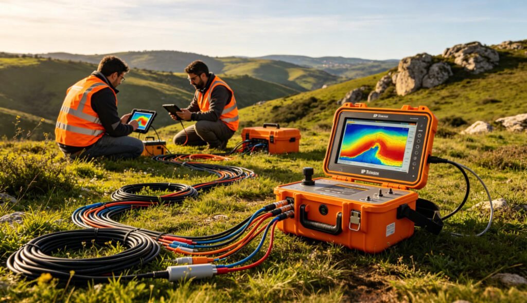
Avrupa Minerals Ltd. has confirmed a 6.5 million tonne copper-zinc resource at its Sesmarias project in northern Portugal. The deposit sits within the legendary Iberian Pyrite Belt (IPB). This belt ranks among the world’s most productive volcanogenic massive sulphide (VMS) districts. The discovery highlights a critical truth. Modern geophysical exploration methods now drive VMS discovery in mature terrains. Induced Polarization (IP) and Electrical Resistivity Tomography (ERT) remain the premier tools for locating concealed sulphide bodies. This article examines the Sesmarias discovery. It explores how IP, ERT, proton magnetometer, and integrated geophysical strategies unlock hidden VMS wealth across the IPB.
Ⅱ. The Sesmarias Discovery: A New VMS Benchmark
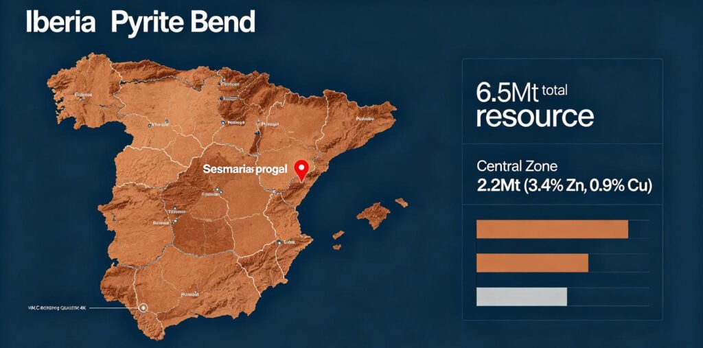
1.Resource Scale and Grade
The initial NI 43-101-compliant mineral resource estimate reports 6.5 million tonnes grading 2.9% zinc, 1.2% lead, 0.6% copper, and 35 g/t silver. This equates to a copper equivalent (CuEq) grade of 2.2% or a zinc equivalent (ZnEq) of 6.2%. The resource spans four distinct zones. The Central Zone carries the highest grades at 3.4% zinc and 0.9% copper across 2.2 million tonnes. SLR Consulting compiled the estimate. The effective date is 1 May 2026.
2.Geological Setting
Sesmarias lies in the northern Iberian Pyrite Belt. This belt hosts over 90 VMS deposits with original massive sulphide tonnage exceeding 1,600 million tonnes. The project sits within a synformal fold structure. Known strike length reaches at least 1,700 metres. The IPB represents one of Earth’s largest sulphide concentrations. It stretches across southern Spain and Portugal. The belt formed during the Famennian to Late Visean period. Ancient submarine hydrothermal systems deposited metal-rich sulphides on the seafloor.
3.Expansion Potential
SLR Consulting identified seven drill targets beyond the current resource. Two are extensional targets. Five are conceptual. At a 3% ZnEq cut-off, sensitivity analysis suggests the deposit could contain up to 10.6 million tonnes grading 5.1% ZnEq. Avrupa Minerals now seeks a joint-venture partner. The company aims to fund the next drilling campaign. Pre-feasibility studies will follow.
Ⅲ. Geophysical Methods in VMS Exploration: The IPB Success Story
1.Why IP and ERT Dominate VMS Discovery
Induced Polarization (IP) stands as the premier tool for VMS exploration. VMS deposits contain metallic sulphides. These minerals generate strong chargeability responses. IP measures this delayed voltage release. The method distinguishes ore from conductive clays. It detects disseminated sulphides that other methods miss. In the IPB, IP surveys have guided discovery of multiple hidden deposits. The Lagoa Salgada orebody in Portugal was found under 128 metres of Tertiary cover. Gravity surveys identified the target. IP and TEM surveys then defined mineralization extent. This 1992 discovery confirmed the IPB’s northwest sector potential.
2.ERT and DC Resistivity Sounding for Deep Targets
Electrical Resistivity Tomography (ERT) provides 2D/3D subsurface imaging. It maps resistivity contrasts between sulphide bodies and host rocks. Modern ERT systems achieve 1,500-metre depth penetration. DC Resistivity Sounding complements ERT with deep vertical profiling. Vertical Electrical Sounding (VES) protocols feed into multi-electrode arrays. This hybrid approach covers both regional reconnaissance and detailed target delineation. In VMS terrains, low-resistivity anomalies often indicate massive sulphide lenses. High-resistivity zones may mark silicified alteration halos. The combination guides drill targeting with precision.
3.Magnetic Surveys: Mapping the Volcanic Framework
Proton Precession Magnetometer (PPM) technology maps the volcanic architecture hosting VMS deposits. IPB VMS deposits form within specific volcanic sequences. Magnetic surveys distinguish these units from non-volcanic rocks. Magnetic lows often indicate intense alteration zones. These halos surround mineralized areas. Magnetic highs map associated intrusive rocks. In the Sesmarias region, regional aeromagnetic data define IPB lineaments. These structures control mineralization distribution. Handheld PPM devices enable rapid ground follow-up. Surveyors complete large grids quickly. Data syncs to GIS platforms via Bluetooth. This speed accelerates target refinement.
Ⅳ. Case Studies: Geophysics in Action Across the IPB
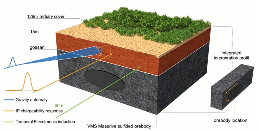
1.Lagoa Salgada: The Classic IPB Discovery Model
The Lagoa Salgada discovery in Portugal’s Sado Tertiary Basin exemplifies IPB exploration methodology. Gravimetry identified regional targets. Magnetometry, resistivity, electrical sounding, and magnetotelluric methods followed. The orebody lay beneath 128m of cover with a 15m-thick gossan. Drilling intersected massive sulphides exceeding 60 metres. The initial resource reached 5 million tonnes. This case proves that integrated geophysics overcomes cover challenges. It validates investment in multi-method surveys.
2.Las Cruces: Gravity Leads to Giant Discovery
In Spain’s IPB sector, the Las Cruces deposit was discovered by regional gravity survey. The survey indicated Pyrite Belt lithologies beneath 120 metres of cover. The 14.5 million tonne deposit occurs in altered felsic to intermediate volcanic units. IP and TEM surveys effectively defined mineralization extent. The deposit sits within 18 km of Seville. This proximity to infrastructure enhances economic viability. The discovery underscores gravity’s role in regional VMS targeting.
3.Neves-Corvo: Modern 3D Geophysical Integration
The Neves-Corvo mine complex represents IPB exploration at its most advanced. LNEG’s EXPLORA project applied gravity inversion, magnetic inversion, and electromagnetic data inversion. These methods identified high-density anomalies linked to regional conductive horizons. Drill holes confirmed ore and stockwork mineralization. The project built comprehensive databases. These include drill hole data, lithogeochemistry, petrophysics, and geochronology. 3D geological modelling now guides near-mine and greenfield exploration. This integrated approach maximizes discovery probability.
Ⅴ. Technology Trends: The Future of VMS Geophysics
1.Spectral IP and Spread Spectrum Innovation
Traditional IP surveys face limitations. Spectral Induced Polarization (SIP) measures frequency-dependent responses. It distinguishes ore from non-ore anomalies using Cole-Cole model parameters. However, standard SIP frequency bands (0.125–1024 Hz) cannot capture time constants of large massive sulphide deposits. These often exceed 1,000 seconds. Spread Spectrum Induced Polarization (SSIP) solves this problem. It determines optimal frequency bands from rock and ore specimen analysis. SSIP then conducts deep measurements using these bands. The method works like seismic exploration. It acquires data simultaneously on multiple survey lines. This approach has achieved breakthroughs at the Baiyinchang VMS deposit in China. It also succeeded at the Guchenghu copper-lead-zinc deposit in Jiangsu.
2.3D Resistivity and Chargeability Modelling
Modern 3D ERT + IP surveys offer unprecedented resolution. They map alteration, lithology, and sulphide mineralization simultaneously. In VMS systems, zinc-rich deposits may not be highly conductive. EM systems can fail here. Resistivity and IP methods remain sensitive to weakly conductive or disseminated mineralization. DIAS32 3D resistivity and chargeability surveys add significant value. They work in both greenfield and brownfield environments. The technology has proven effective in Sweden’s Skellefte district. There, 3D resistivity/IP data identified new VMS targets. These targets sit at depths exceeding 2.2 kilometres.
3.AI-Driven Interpretation and Multi-Method Fusion
Artificial intelligence now automates anomaly detection. Machine learning algorithms classify geophysical signatures. They distinguish VMS targets from barren conductive zones. Multi-method data fusion combines IP, EM, gravity, and magnetic datasets. This integration reduces false positives. It improves drill targeting accuracy. In the IPB, LNEG’s regional mapping programs compile data from the 1960s onward. Modern processing reveals new exploration vectors. These vectors correlate geophysics with geochemistry and stratigraphy. The approach is essential for discovering new giant (>200 Mt) deposits.
Ⅵ. Equipment Solutions for VMS Exploration
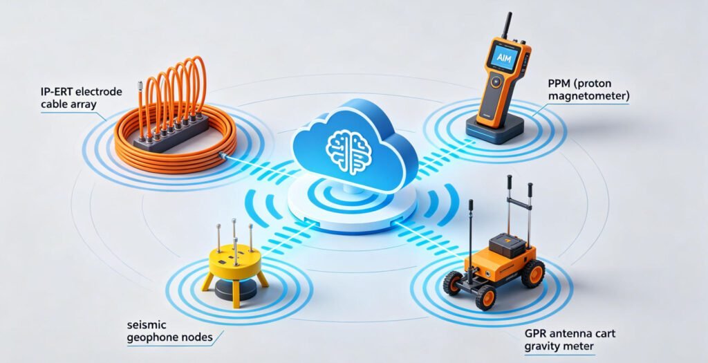
1.IP-ERT Integrated Systems
Modern exploration demands multi-parameter acquisition. Systems combining IP and ERT modules reduce field time. They collect chargeability and resistivity data simultaneously. GeoRes-IP Pro offers 256-channel synchronization. It enables deep metal ore modelling. HDR-IP360 provides chargeability-resistivity dual imaging. These systems are critical for IPB-style VMS exploration. They distinguish chalcopyrite from pyrite. They map alteration halos around ore lenses.
2.Proton Magnetometer for Rapid Reconnaissance
The JPMG Proton Magnetometer delivers 0.05nT sensitivity across a 20,000–120,000nT dynamic range. Its OCXO-stabilized system ensures ±0.1nT absolute accuracy. The device operates in mobile, walking, and base modes. It withstands temperatures from -40°C to +55°C. In IPB exploration, such instruments map volcanic unit boundaries. They identify alteration zones. They guide follow-up IP and EM surveys. The magnetometer remains the first geophysical tool deployed in most greenfield programs.
3.Seismic and GPR Complementary Methods
Seismic reflection profiles define deep geological structures. In the IPB, they image the Volcano-Sedimentary Complex (VSC) basement. They identify synformal fold hinges where VMS lenses concentrate. Ground Penetrating Radar (GPR) resolves shallow cover thickness. It maps gossan and supergene alteration zones. These methods complement electrical and magnetic surveys. They provide comprehensive site characterization.
Ⅶ. Strategic Outlook: The IPB Renaissance
1.Critical Minerals Drive Renewed Interest
The IPB is experiencing significant momentum. This aligns with energy transition, digital economy, and sustainable mining priorities. The belt supplies copper, zinc, lead, and silver. These metals are essential for EV batteries, renewable energy infrastructure, and electronics. The European Critical Raw Materials Act prioritizes domestic supply. The IPB stands as Europe’s premier VMS province. It offers strategic security for these materials.
2.Underexplored Western Sector Potential
The western IPB remains relatively underexplored compared to the eastern sector. Projects like Iberian Belt West (IBW) and Sesmarias target this gap. The western region hosts favorable host rocks. It shows stacked lens geometry. Strong historical drill results support extension potential. Modern geophysics, relogging, and structural modeling optimize drill targeting. The approach mirrors successful eastern IPB discoveries.
3.Investment in Advanced Geophysical Methods
LNEG researchers predict increased investment in new geophysical methods. The IPB potential for VMS deposits justifies this trend. Possibilities include discovering new giant deposits. Multi-layered data correlation is key. This combines geophysics, petrophysics, geochemistry, and stratigraphic models. It enables accurate ore horizon modeling. It reduces exploration risk. It maximizes capital efficiency.
Reference
- MinEx Forum. (2026). Avrupa Minerals Confirms 6.5 Million Tonne Copper-Zinc Resource at Portugal’s Sesmarias Project. Retrieved from https://minexforum.com/avrupa-minerals-confirms-6-5-million-tonne-copper-zinc-resource-at-portugals-sesmarias-project/
- Oliveira, V.M.J., Matos, J.X., et al. (1997). Geology and geophysics as successful tools in the discovery of the Lagoa Salgada Orebody (Sado Tertiary Basin – Iberian Pyrite Belt), Grândola, Portugal. Mineralium Deposita, 33, 170-187.
- Matos, J.X., et al. (2020). Geophysical surveys in the Portuguese sector of the Iberian Pyrite Belt: a global overview focused on the massive sulphide exploration and geologic interpretation. LNEG Publications.
- U.S. Geological Survey. (2010). Geophysical Characteristics of Volcanogenic Massive Sulfide Deposits. Scientific Investigations Report 2010-5070-C, Chapter 7.
- Dias Geophysical. (2026). 3D IP and Resistivity for Mineral Exploration. Retrieved from https://diasgeo.com/expertise/sectors-we-serve/mineral-exploration/
- Kavango Resources. (2026). Induced Polarisation (IP) Surveying in VMS Exploration. Retrieved from https://www.kavangoresources.com/our-approach/exploration-technologies/induced-polarisation-ip-surveying/
- Geotech Instrument Co., Ltd. (2026). JPMG Proton Magnetometer Technical Specifications. Retrieved from https://geotechcn.net/products/magnetic-instrument/geo-m-proton-magnetometer/
- Geotech Instrument Co., Ltd. (2026). Induced Polarization (IP) Method Explained. Retrieved from https://geotechcn.net/service/what-is-induced-polarization-ip-method-a-comprehensive-technical-guide/
FAQ: VMS Exploration and Geophysical Methods
Q1: Why is Induced Polarization (IP) the preferred method for VMS exploration?
IP measures chargeability from metallic sulphides. VMS deposits contain copper, zinc, and lead sulphides. These generate high chargeability responses. IP distinguishes them from conductive clays and graphite. It detects disseminated mineralization that EM methods miss. This sensitivity makes IP essential for early-stage VMS targeting.
Q2: Can ERT alone locate VMS deposits?
No. ERT maps resistivity contrasts. It identifies low-resistivity sulphide zones and high-resistivity alteration halos. However, VMS exploration requires multi-method integration. IP provides chargeability data. Magnetics map volcanic architecture. Gravity detects excess mass. The combination reduces false positives and improves drill success rates.
Q3: How does the proton magnetometer contribute to VMS exploration?
PPM devices map magnetic properties of volcanic host rocks. VMS deposits associate with specific volcanic sequences. Magnetic surveys identify these units. They detect alteration zones with magnetic lows. They map intrusive rocks with magnetic highs. This framework guides IP and EM follow-up surveys. PPM remains the fastest, most cost-effective regional reconnaissance tool.
Q4: What challenges does cover rock present in IPB VMS exploration?
The IPB contains extensive areas concealed by younger sediments. These include the Baixo Alentejo Flysch Group and Cenozoic formations. Cover thickness ranges from tens to hundreds of metres. Geophysical methods overcome this challenge. Gravity and magnetics define basement structures beneath cover. IP and EM detect sulphide conductors at depth. Deep-penetrating ERT and MT methods image the full stratigraphic column.
Q5: What is the role of spectral IP in modern VMS exploration?
Spectral IP measures frequency-dependent polarization responses. Different sulphide minerals exhibit distinct spectral signatures. Chalcopyrite, sphalerite, and pyrite each have characteristic time constants. Spectral IP distinguishes these minerals. It helps geologists predict ore grade and metal ratios before drilling. Spread Spectrum IP (SSIP) extends this capability to large, deep deposits. It improves exploration efficiency and targeting accuracy.