Welcome to Geotech!

Which kind of GIM ERT DC System is suitable for Global Groundwater Exploration?
TIPS :An ERT resistivity imaging system is the core tool for global groundwater assessment, and the GIM Series DC ERT equipment optimizes every stage of field ERT survey workflow. This full guide breaks down the technical strengths of the GIM Series ERT resistivity imaging system, compares GIM-1/GIM-5/GIM-10 models, and shares real case data proving how this GIM Series DC ERT equipment cuts exploration cost while boosting drilling success rates across Africa, Australia and Southeast Asia.

Introduction
Electrical Resistivity Tomography (ERT) has become one of the most widely adopted geophysical methods for investigating subsurface conditions in groundwater exploration, mineral exploration, environmental studies, geotechnical engineering, and infrastructure assessment. As exploration targets become deeper and project timelines become shorter, modern survey teams require faster, more accurate, and more reliable resistivity imaging systems.
Electrical Resistivity Tomography enables geophysicists to visualize underground structures without drilling extensive boreholes. Through advanced resistivity imaging techniques, geological anomalies, groundwater-bearing formations, mineralized zones, and engineering hazards can be identified with greater confidence.
The GIM Series DC Electrical System developed by Geotech Instrument represents a new generation of high-density electrical survey technology. As part of the company’s advanced Electrical Resistivity Tomography Equipment portfolio, the system integrates resistivity imaging, induced polarization, and high-density electrical survey capabilities into a single platform.
Today, engineering companies, geological survey organizations, mining contractors, and groundwater exploration teams across North America, Australia, Africa, Southeast Asia, South America, and the Middle East rely on advanced ERT equipment to improve exploration efficiency, reduce project risks, and optimize drilling decisions.
Ⅰ. What Is Electrical Resistivity Tomography and Why Is It Important?
1. Understanding Electrical Resistivity Tomography
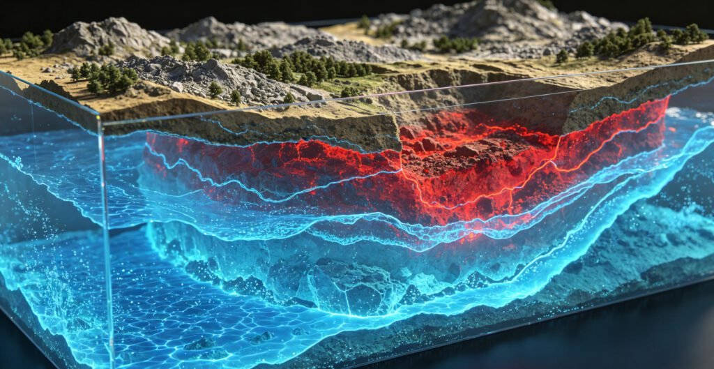
Electrical Resistivity Tomography (ERT) is a geophysical imaging technique that measures the electrical resistivity distribution beneath the Earth’s surface. By injecting controlled electrical current into the ground and recording voltage differences through multiple electrodes, surveyors can generate detailed two-dimensional and three-dimensional subsurface models.
ERT is widely used to identify:
- Groundwater aquifers
- Geological faults
- Karst cavities
- Mineralized zones
- Contamination plumes
- Buried infrastructure
- Engineering hazards
Unlike conventional drilling programs, Electrical Resistivity Tomography provides continuous subsurface coverage while minimizing environmental disturbance and project costs.
According to the U.S. Geological Survey (USGS), geophysical imaging technologies play an increasingly important role in groundwater assessment, geological hazard evaluation, and mineral resource investigations worldwide.
2. Evolution from Traditional Resistivity Surveys
Traditional Vertical Electrical Sounding (VES) was once the dominant electrical exploration method. However, as geological targets became more complex, limitations in one-dimensional interpretation became increasingly apparent.
Modern Electrical Resistivity Tomography now supports:
- 2D Resistivity Imaging
- 3D Resistivity Imaging
- Time-Lapse Monitoring
- Multi-Channel Acquisition
- Integrated Induced Polarization Surveys
These advancements enable geophysicists to achieve higher-resolution imaging and more accurate geological interpretations.
Ⅱ. Challenges Facing Modern Geophysical Exploration Projects
1. Increasing Demand for Deep Exploration
Mining companies worldwide are searching for deeper ore bodies as near-surface resources become depleted. Groundwater specialists are exploring deeper aquifers to address growing water shortages.
These exploration objectives require:
- Greater transmission power
- Improved signal quality
- Enhanced imaging resolution
- Higher data density
2. Harsh Field Conditions
Many geophysical projects operate in difficult environments.
Australia
Large-scale mining projects often require survey lines extending several kilometers across remote terrain.
Africa
Groundwater investigations frequently encounter logistical challenges and limited power infrastructure.
Southeast Asia
Tropical climates expose equipment to high humidity, heavy rainfall, and dense vegetation.
North America
Urban infrastructure investigations demand accurate imaging in highly complex underground environments.
3. Pressure to Increase Survey Efficiency
Modern exploration contractors face increasing pressure to complete projects faster while reducing operational costs.
Survey teams require systems capable of:
- Automated measurements
- Faster acquisition rates
- Reduced labor requirements
- Improved productivity
Ⅲ. How the GIM Series Addresses These Challenges
1. High-Power Transmission Capability
The GIM Series is engineered to deliver exceptional transmission performance for demanding geological investigations.
Key specifications include:
- Up to 3200W transmission power
- Maximum 1200V output voltage
- Up to 6A transmission current
- High signal stability
These capabilities enable deeper penetration and more reliable data acquisition, especially in high-resistivity geological environments.
2. Intelligent Electrode Switching
Traditional resistivity systems often rely on manual switching procedures that increase field time and introduce potential human error.
The GIM Series incorporates intelligent automatic electrode control, providing:
- Faster acquisition cycles
- Reduced operator workload
- Improved consistency
- Enhanced productivity
3. Multi-Channel Parallel Acquisition
High-density surveys generate substantial datasets that require efficient acquisition systems.
The GIM Series supports:
- Parallel measurements
- High-density electrode arrays
- Large-scale survey expansion
- Efficient 2D and 3D imaging
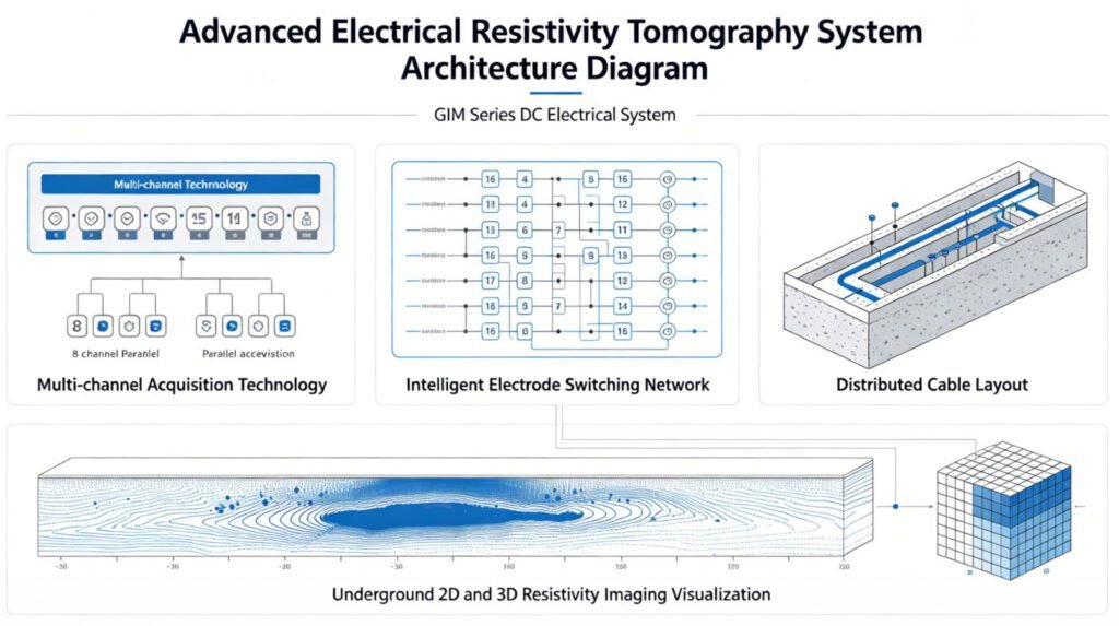
This significantly reduces field acquisition time while improving overall survey coverage.
The GIM platform is supported by a complete range of High Density Electrical Method Solutions, allowing geological survey organizations and engineering contractors to implement customized workflows for groundwater exploration, mining exploration, and infrastructure investigations.
Ⅳ. GIM-1 vs GIM-5 vs GIM-10: Choosing the Right Resistivity Imaging System
Selecting the appropriate Electrical Resistivity Tomography equipment depends on project scale, target depth, and operational requirements.
| Feature | GIM-1 | GIM-5 | GIM-10 |
|---|---|---|---|
| Project Scale | Small | Medium | Large |
| Survey Depth | Moderate | Deep | Ultra Deep |
| Data Density | Standard | High | Very High |
| 3D Imaging | Basic | Advanced | Full Capability |
| Mining Exploration | Good | Better | Best |
| Groundwater Survey | Excellent | Excellent | Excellent |
| Infrastructure Survey | Excellent | Excellent | Excellent |
Recommended Applications
GIM-1
Best suited for:
- Groundwater investigations
- Environmental studies
- Engineering site assessments
GIM-5
Recommended for:
- Medium-scale mining projects
- Geotechnical investigations
- Infrastructure development projects
GIM-10
Ideal for:
- Deep mineral exploration
- Regional geological surveys
- Large-scale ERT programs
Ⅴ. Real-World Applications of the GIM Series
1. Groundwater Exploration in Africa
Water scarcity remains a critical challenge throughout many African regions.
Using Electrical Resistivity Tomography, hydrogeologists can identify:
- Productive aquifers
- Fracture-controlled groundwater systems
- Recharge zones
- Optimal drilling locations
This significantly improves drilling success rates and reduces project costs.
The International Association of Hydrogeologists (IAH) highlights geophysical methods as highly cost-effective tools for groundwater resource evaluation in water-scarce regions.
2. Mineral Exploration in Australia
Australian mining companies frequently combine resistivity and induced polarization surveys to identify:
- Sulfide mineralization
- Copper deposits
- Gold-bearing structures
- Hydrothermal alteration zones
The GIM Series provides the data quality required for targeting concealed mineral deposits and reducing exploration risk.
Industry best practices promoted by the Society of Exploration Geophysicists (SEG) recognize integrated resistivity and induced polarization surveys as valuable tools for identifying hidden mineralization.
3. Geotechnical Investigations in Southeast Asia
Infrastructure development projects require accurate subsurface characterization before construction begins.
Applications include:
- Highway construction
- Railway development
- Dam safety investigations
- Tunnel engineering
- Urban development projects
Research published by the British Geological Survey (BGS) demonstrates the effectiveness of resistivity imaging in identifying subsurface instability and engineering hazards.
4. Urban Infrastructure Surveys in the United States
Urban planners and engineering firms increasingly rely on non-destructive geophysical methods.
The GIM Series supports:
- Utility mapping
- Sinkhole detection
- Underground void identification
- Infrastructure risk assessment
These applications help reduce construction risks and improve project planning.
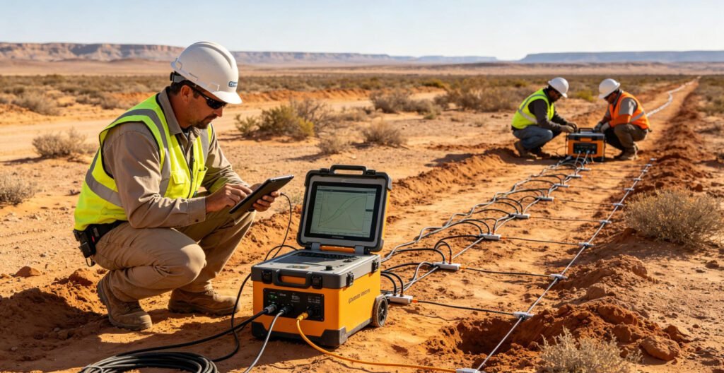
Ⅵ. Step-by-Step Guide to Conducting an ERT Survey
Step 1: Survey Planning
Define project objectives, target depth, geological conditions, and survey layout.
Step 2: Electrode Installation
Deploy electrodes according to the selected array configuration and survey design.
Step 3: Equipment Calibration
Verify instrument performance, communication integrity, and electrode contact resistance.
Step 4: Data Acquisition
Perform automated resistivity and induced polarization measurements using optimized acquisition parameters.
Step 5: Data Processing
Import field data into inversion software, perform quality control, and generate resistivity models.
Step 6: Geological Interpretation
Interpret subsurface structures and integrate findings with geological and drilling information.
Ⅶ. Best Practices for Accurate Resistivity Imaging
Ensure Good Electrode Contact
Poor contact resistance can negatively impact data quality and reduce interpretation accuracy.
Select the Appropriate Electrode Array
Wenner Array
Offers strong signal strength and excellent noise resistance.
Schlumberger Array
Provides greater depth penetration.
Dipole-Dipole Array
Delivers superior lateral resolution for geological mapping.
Conduct Data Quality Control
Review data quality before leaving the survey area to avoid costly remobilization.
Use Appropriate Inversion Parameters
Proper inversion settings significantly improve the reliability of geological interpretation.
Ⅷ. Why Engineering Firms and Mining Companies Prefer the GIM Series
The GIM Series provides measurable operational advantages.
Reduced Field Time
Multi-channel acquisition accelerates survey completion.
Lower Operating Costs
Automation reduces labor requirements and operational expenses.
Higher Data Reliability
Stable transmission technology improves imaging quality and interpretation confidence.
Flexible Expansion
Modular architecture supports projects ranging from small engineering investigations to regional exploration campaigns.
Global Adaptability
The system performs reliably in deserts, mountains, tropical forests, mining districts, and urban environments.
Ⅸ. Future Trends in Electrical Resistivity Tomography
The geophysical industry continues to evolve rapidly.
Emerging technologies include:
- Artificial Intelligence-assisted interpretation
- Cloud-based geophysical processing
- Real-time subsurface imaging
- 4D monitoring systems
- Autonomous survey platforms
International technical conferences organized by the European Association of Geoscientists and Engineers (EAGE) continue to showcase innovations in real-time imaging, automated interpretation, and advanced geophysical monitoring technologies.
Organizations investing in next-generation Electrical Resistivity Tomography systems will be better positioned to address future exploration challenges.
Ⅹ. Why Geotech Is a Trusted Partner for Global Exploration Projects
Geotech Instrument has established itself as a professional supplier of advanced geophysical survey equipment serving customers worldwide.
The company supports projects involving:
- Groundwater exploration
- Mineral exploration
- Geotechnical investigation
- Environmental assessment
- Infrastructure inspection
Through continuous product innovation and field-proven solutions, Geotech helps exploration teams achieve higher survey efficiency and more reliable geological results.
Conclusion
Electrical Resistivity Tomography has become an essential technology for modern geophysical exploration. Whether investigating groundwater resources, exploring mineral deposits, assessing engineering risks, or monitoring environmental conditions, high-quality resistivity imaging is critical for successful decision-making.
The GIM Series DC Electrical System combines advanced transmission power, intelligent automation, multi-channel acquisition, and rugged field performance to meet the growing demands of global exploration projects.
Organizations seeking reliable Geophysical Survey Equipment can leverage Geotech’s expertise in resistivity imaging, induced polarization, seismic instruments, magnetometers, and integrated exploration technologies. The GIM Series provides a comprehensive solution capable of supporting a wide range of geophysical applications worldwide.
Reference Source
Society of Exploration Geophysicists (SEG) – Authoritative industry organization
USGS Geophysical Methods – Standard of the United States Geological Survey
EAGE (European Association of Geoscientists)
FAQ
What is Electrical Resistivity Tomography used for?
Electrical Resistivity Tomography is used to image underground structures for groundwater exploration, mineral exploration, environmental assessment, and geotechnical investigations.
How deep can a GIM Series resistivity survey investigate?
Investigation depth depends on geological conditions, electrode spacing, and survey configuration. Under favorable conditions, deep exploration targets can be investigated effectively.
What is the difference between ERT and DC Resistivity Sounding?
ERT generates detailed two-dimensional and three-dimensional subsurface images, while traditional DC Resistivity Sounding primarily provides one-dimensional information.
Can Electrical Resistivity Tomography detect groundwater?
Yes. ERT is one of the most effective geophysical methods for identifying aquifers, fracture zones, and groundwater-bearing formations.
Why is Induced Polarization important in mining exploration?
Induced Polarization helps identify chargeable materials such as sulfide mineralization, making it highly valuable for mineral exploration programs.