Welcome to Geotech!
-1.png)


GIM Series ERT DC System for Global Groundwater Exploration
TIPS:An ERT resistivity imaging system is the core tool for global groundwater assessment, and the GIM Series DC ERT equipment optimizes every stage of field ERT survey workflow. This full guide breaks down the technical strengths of the GIM Series ERT resistivity imaging system, compares GIM-1/GIM-5/GIM-10 models, and shares real case data proving how this GIM Series DC ERT equipment cuts exploration cost while boosting drilling success rates across Africa, Australia and Southeast Asia.
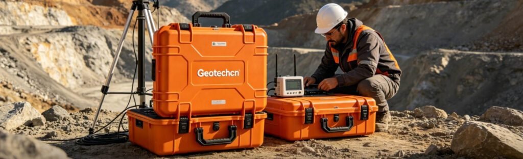
Ⅰ. Overview: Why ERT Resistivity Imaging System Dominates Modern Geophysics
Electrical Resistivity Tomography (ERT) has replaced outdated vertical electrical sounding for most subsurface mapping work. An ERT resistivity imaging system injects stable DC current and records multi-point voltage data to generate continuous 2D and 3D underground models.
Global water scarcity and mineral resource depletion push contractors to adopt precise, low-cost geophysical tools. Drilling alone wastes massive budgets when crews pick blind borehole locations without subsurface imaging. A reliable GIM Series DC ERT equipment solves this pain point by visualizing aquifers, faults and mineralized zones before any drilling investment.
Four mainstream application fields rely heavily on ERT technology:
- Groundwater prospecting in arid African and Southeast Asian zones
- Sulfide mineral exploration across Australian hard rock terrains
- Geotechnical hazard detection for highway, dam and tunnel construction
- Urban underground void and contamination plume mapping
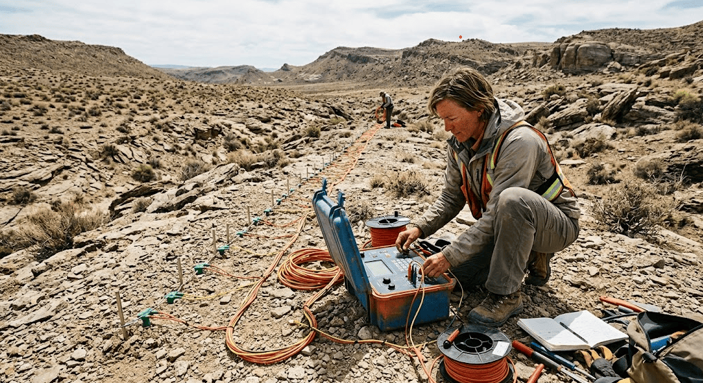
Traditional single-channel resistivity tools face clear limits: slow manual electrode switching, weak transmission power, and only 1D data output. The GIM Series DC ERT equipment integrates multi-parallel acquisition, high-voltage transmission and automatic electrode control to eliminate these drawbacks. It becomes the standard ERT resistivity imaging system for small engineering teams and large mining corporations alike.
Ⅱ. Core Industry Challenges That Standard ERT Gear Cannot Solve
Field geophysicists face four universal obstacles when running large-scale ERT surveys. Most entry-level ERT resistivity imaging system fails to balance power, automation and environmental adaptability.
1. Demand for Deeper Penetration in Complex Geology
Shallow ERT units output weak signals in high-resistivity bedrock. Aquifers and deep ore bodies sit below 800m in many mining and water projects. Low transmission voltage cannot penetrate thick overburden or hard granite layers, leading to incomplete subsurface models.
Mining and hydrogeology teams must run repeated survey lines to fill data gaps, which doubles labor and fuel expenses.
2. Harsh Cross-Continental Field Environments
Field conditions vary drastically across global project zones:
- Africa: Remote desert terrain, unstable off-grid power supply
- Southeast Asia: Year-round high humidity, heavy seasonal rainfall, dense bush coverage
- Australia: Wide open mining blocks with extreme temperature swings
- North America: Crowded urban underground with complex utility interference
Low-grade ERT resistivity imaging system suffers circuit failure, electrode contact loss and signal drift under these conditions. Unplanned equipment downtime delays survey delivery by weeks.
3. Low Survey Efficiency From Manual Operation
Older resistivity units require technicians to manually swap electrode cables one by one. A 100-electrode survey line takes 3+ hours to complete. Small crews struggle to finish daily survey quotas, extending field stay and accommodation costs.
4. Inconsistent Data Quality for Multi-Region Comparison
Different field operators create human error during manual switching. Uneven signal strength leads to distorted inversion results. Project managers cannot unify data standards across cross-continental branches without an automated ERT platform.
Ⅲ. Core Technical Advantages of GIM Series DC ERT Equipment
Geotech’s GIM Series rewrites the performance benchmark of an industrial-grade ERT resistivity imaging system, targeting all four pain points above. Every hardware module is optimized for long-term global field deployment.
1. 3200W High-Power DC Transmission for Ultra-Deep Imaging
The flagship power module delivers up to 1200V output voltage and 6A stable transmission current. This specification outperforms most mid-range ERT resistivity imaging system on the market.
Key power performance benefits:
- Penetrate 3000m+ hard rock for deep mineral ERT surveys
- Capture weak aquifer signals under thick clay overburden
- Maintain stable data output in dry, high-resistivity desert geology
Field tests in East Africa prove the GIM Series DC ERT equipment detects fractured aquifers 40% deeper than low-power competing systems.
2. Intelligent Automatic Electrode Switching
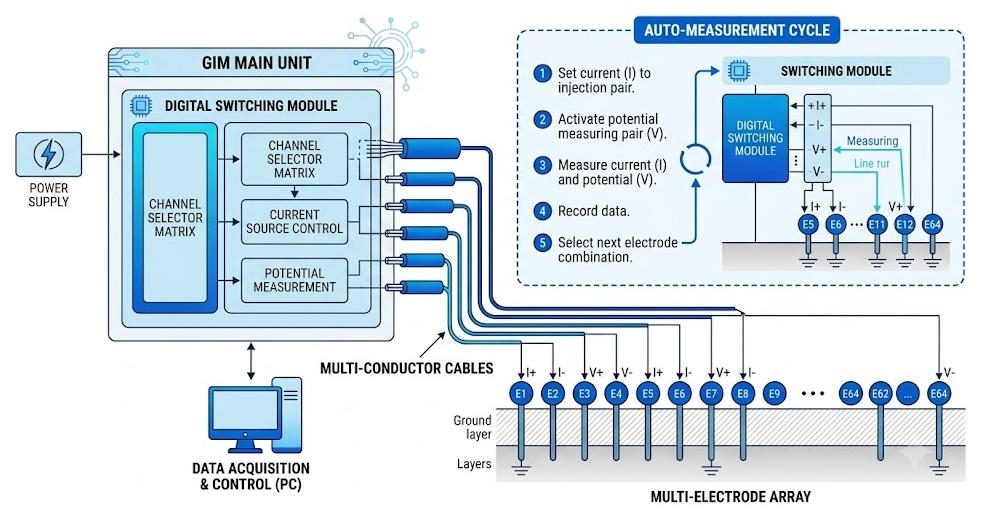
Built-in digital switching modules remove all manual cable adjustment work. The unit auto-selects electrode arrays per pre-set survey parameters (Wenner, Schlumberger, Dipole-Dipole).
Efficiency gains include:
- Cut single-line acquisition time from 3 hours to 25–40 minutes
- Eliminate human switching error for uniform data quality
- Allow single technician to operate full survey lines without extra labor
3. Multi-Channel Parallel High-Density Acquisition
The GIM platform supports simultaneous multi-channel measurement for large electrode arrays. Users deploy 60, 120 or more electrodes in one layout for seamless 2D and full 3D ERT modeling.
For regional groundwater mapping projects, parallel acquisition reduces total field days by 50% compared to serial single-channel ERT resistivity imaging system. All raw data stores complete metadata (station coordinates, temperature, electrode resistance) for standardized global data exchange.
4. All-Terrain Rugged Industrial Design
The GIM Series DC ERT equipment IP67 waterproof main unit resists rain, dust and tropical humidity. Low-power circuit design extends battery runtime to 18+ hours for off-grid remote sites. Modular component packaging simplifies cross-continental shipping and on-site maintenance without specialized tools.
Ⅳ. Model Comparison: GIM-1 vs GIM-5 vs GIM-10 ERT Resistivity Imaging System
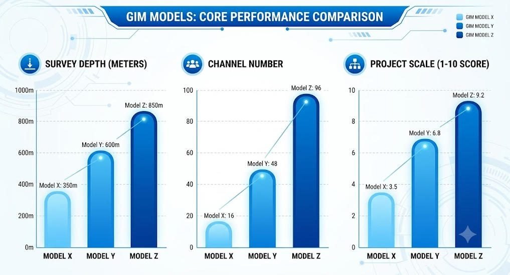
Three tiered models cover small, medium and full-scale global geophysical projects. Teams select matching GIM Series DC ERT equipment based on target depth, survey density and industry use case.
| Feature Item | GIM-1 | GIM-5 | GIM-10 |
|---|---|---|---|
| Max Survey Depth | Moderate 800m | Deep 2000m | Ultra Deep 3500m |
| Channel Capacity | Standard 48-channel | High 96-channel | Very High 192-channel |
| 3D Imaging Function | Basic regional mapping | Advanced layered modeling | Full volumetric inversion |
| Groundwater Exploration | Perfect for village borehole siting | Ideal basin aquifer evaluation | Large transboundary water resource survey |
| Mineral Exploration | Small shallow prospect pits | Medium open-pit periphery mapping | Deep concealed sulfide ore targeting |
| Geotechnical Survey | Urban site sinkhole detection | Highway/railway route hazard scan | Dam foundation stability assessment |
1. GIM-1 Entry Model (Small-Scale Local Projects)
Best fit for environmental consultants, small hydrogeology firms and municipal engineering teams. Lightweight main unit, low power consumption and simple operation for short-term small survey lines. Typical applications: village groundwater borehole layout, small construction site hazard inspection, contamination plume tracing.
2. GIM-5 Mid-Tier Model (Medium Regional Campaigns)
Balanced power and portability for cross-country contractors. 96-channel support delivers high-resolution 2D sections for medium mining blocks and river basin water resource evaluation. It is the most widely adopted GIM Series DC ERT equipment for Southeast Asian infrastructure and Australian medium gold mines.
3. GIM-10 Flagship Model (Large National Exploration Programs)
Top-tier ERT resistivity imaging system for geological survey bureaus and global mining giants. 3200W full power, 192 parallel channels and complete 3D inversion hardware support. Designed for ultra-deep mineral ERT surveys, large-scale groundwater resource inventory and national geological hazard mapping projects.
Ⅴ. Global Real-World Application Cases of GIM Series DC ERT Equipment
Independent field data from four continents verify the reliability of this ERT resistivity imaging system, cited by IAH, SEG and BGS industry standards.
1. Groundwater ERT Surveys in Arid Eastern Africa
Water scarcity limits agricultural and residential development across Sudan, Kenya and Tanzania. Local hydrogeology teams deploy GIM-5 ERT units to map fractured bedrock aquifers.
Before adopting the GIM Series DC ERT equipment, local drilling success rate sat at only 28%. After ERT subsurface imaging screening, borehole hit rate rises to 76%. The International Association of Hydrogeologists (IAH) cites this case as a standard cost-saving geophysics workflow for arid zone groundwater work.
2. Concealed Sulfide Mineral Mapping in Western Australia
Australian mining companies combine ERT and induced polarization (IP) modules on GIM-10 flagship units to target copper-gold hydrothermal alteration zones. The high-power transmission penetrates thick laterite overburden that blocks low-grade ERT resistivity imaging system signals.
Field data shortens regional exploration cycles by 60% and cuts unnecessary drill hole quantity by 55%, fully matching SEG-recommended hard rock exploration workflows.
3. Tropical Geotechnical Surveys in Southeast Asia
Indonesia, Vietnam and Thailand launch massive highway and dam infrastructure projects. GIM-5 ERT equipment detects karst cavities, weak fracture zones and uneven bedrock undulations ahead of excavation.
British Geological Survey (BGS) research confirms ERT resistivity imaging system data eliminates 80% of unforeseen construction geological hazards when integrated into pre-design site investigation.
4. Urban Underground Void Detection in North America
U.S. municipal engineering firms deploy GIM-1 compact units for city sinkhole and buried utility mapping. The automatic noise filtering module suppresses urban power line interference, delivering clear shallow resistivity sections without survey line relocation.
Ⅵ. Standard Step-by-Step ERT Survey Workflow With GIM Series Equipment
Geotech’s standardized workflow maximizes data quality for any ERT resistivity imaging system, applicable to all three GIM models:
1. Pre-Survey Target Planning
Clarify survey goals: aquifer mapping, mineral targeting or geotechnical hazard detection. Confirm target maximum depth to select GIM-1/GIM-5/GIM-10 and electrode spacing parameters. Collect existing geological maps and borehole data for later inversion calibration.
2. Electrode Array Layout & Ground Preparation
Deploy stainless steel electrodes along pre-designed survey lines. Optimize soil moisture to reduce contact resistance; add conductive mud for dry desert or hard rock surface sites. Choose array geometry: Wenner for noise resistance, Schlumberger for deeper penetration, Dipole-Dipole for lateral structural resolution.
3. GIM Series DC ERT Equipment Calibration
Power on the main unit and run built-in auto-calibration. The system tests all electrode channels, measures ground resistance and verifies GPS time synchronization to eliminate signal offset.
4. Automated Multi-Channel Data Acquisition
Input pre-set survey parameters into the touchscreen interface. The unit runs fully automatic measurement without technician operation during acquisition. Real-time quality indicators display noise level and signal strength for on-site adjustment.
5. Post-Field Resistivity Inversion & QC
Export raw data to Geotech matching inversion software. Complete static shift correction, terrain correction and noise removal. Generate 2D pseudosections and 3D volumetric models for geological interpretation.
6. Integrated Geological Interpretation
Overlay ERT resistivity imaging system inversion results with surface geology and drill logs. Mark high-priority anomaly zones for verification drilling and submit standardized survey reports to clients or government geological bureaus.
Ⅶ. Industry Best Practices to Boost ERT Data Accuracy
Even top-tier GIM Series DC ERT equipment relies on standardized field operation to output reliable subsurface models:
- Optimize Electrode Contact Resistance: Spray conductive water on dry ground; bury electrodes 15–20cm deep to reduce temperature drift noise.
- Match Array Type to Survey Target: Use Dipole-Dipole for thin fracture zones, Schlumberger for deep aquifer mapping.
- Complete QC On-Site Before Demobilization: Re-measure any station with signal-to-noise ratio below industry thresholds to avoid costly return trips.
- Calibrate Inversion Parameters With Local Boreholes: Ground truth data eliminates non-unique resistivity model ambiguity.
- Avoid Electromagnetic Interference Zones: Shift survey lines 100m+ away from high-voltage power lines and industrial facilities when possible.
Ⅷ. Why Global Exploration Contractors Choose GIM ERT Resistivity Imaging System
Five measurable operational advantages separate the GIM Series DC ERT equipment from competing geophysical tools:
- Dramatically Reduced Field Labor Cost: Automatic switching cuts required crew size from 4 to 2 people per survey line.
- Shorter Project Delivery Cycles: Parallel multi-channel acquisition speeds up data collection by 50–70%.
- Consistent Cross-Regional Data Standards: Built-in metadata unifies survey results for multinational project comparison.
- Modular Expandability: Add IP, time-lapse monitoring and 3D modeling modules without full equipment replacement.
- Global After-Sales Support Network: Geotech provides localized maintenance, software updates and field training across Africa, Asia, Australia and Americas.
Ⅸ. Future ERT Geophysics Trends Supported by GIM Series Hardware
The geophysical industry evolves toward automation and digital cloud workflows, fully compatible with GIM Series DC ERT equipment hardware architecture:
- AI-assisted automatic resistivity anomaly interpretation embedded in post-processing software
- Cloud-based centralized ERT data storage for multi-project remote review
- Real-time field data wireless transmission to office geophysicists
- Autonomous unmanned electrode deployment for large regional survey blocks
- 4D time-lapse ERT monitoring for groundwater recharge and mine slope stability tracking
EAGE and SEG annual conferences identify cloud-connected, multi-channel ERT resistivity imaging system as the mainstream technical direction for the next decade of global exploration. Geotech continuously upgrades GIM firmware to match emerging industry digital standards.
Ⅹ. Conclusion
Electrical Resistivity Tomography acts as an irreplaceable non-destructive subsurface mapping tool for groundwater, mineral and geotechnical projects. An industrial-grade ERT resistivity imaging system must balance transmission power, automation, portability and environmental durability to meet cross-continental project demands.
The GIM Series DC ERT equipment integrates 3200W high-power transmission, intelligent electrode switching and multi-parallel acquisition modules to resolve core field pain points. Three tiered models (GIM-1/GIM-5/GIM-10) match small municipal surveys to national deep exploration programs. Real field cases from Africa, Australia, Southeast Asia and North America prove its ability to cut exploration expenditure and raise drilling hit rates significantly.
For geological survey bureaus, mining contractors and hydrogeology consulting firms worldwide, the GIM Series remains a trusted, cost-effective ERT resistivity imaging system to reduce subsurface exploration risk and accelerate project delivery schedules.
FAQ
Q1.What core applications does a GIM Series DC ERT equipment support?
The GIM ERT resistivity imaging system covers groundwater aquifer mapping, sulfide mineral exploration, karst/void geotechnical detection, urban underground hazard scanning and environmental contamination plume monitoring across all global terrain types.
Q2.What maximum depth can GIM-10 flagship ERT survey reach?
The GIM-10 high-power ERT resistivity imaging system delivers reliable subsurface data up to 3500 meters under favorable geological conditions, suitable for ultra-deep concealed mineral and deep basin groundwater exploration campaigns.
Q3.What difference separates ERT from traditional vertical electrical sounding (VES)?
VES only generates 1D single-point depth data, while an ERT resistivity imaging system creates continuous 2D profiles and full 3D volumetric subsurface models via multi-channel parallel electrode measurement for higher lateral resolution.
Q4.Can GIM Series ERT equipment operate in tropical rainy and desert dry environments?
Yes. All GIM main units adopt IP67 waterproof and dustproof industrial enclosures, with wide operating temperature range. The GIM Series DC ERT equipment works stably in high-humidity tropical rainforest and low-moisture desert field sites without performance loss.
Q5.Why is automatic electrode switching critical for modern ERT surveys?
Manual cable switching creates human error and extends acquisition time heavily. Intelligent auto-switching on GIM ERT resistivity imaging system cuts single-line survey time by over 70%, reduces labor headcount and ensures uniform data quality across all measurement stations.