Welcome to Geotech!
-1.png)


Dual-Sensor Proton Magnetometer for High-Resolution Magnetic Surveys
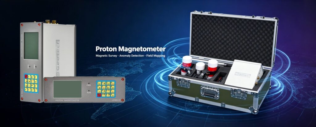
TIPS:The Dual Sensor Proton Magnetometer is designed for geophysical teams that need reliable total-field measurements and magnetic gradient data in field surveys. Using proton precession technology, the JPMG system measures the Earth’s magnetic field and supports simultaneous measurements with two sensors. This Dual Sensor Proton Magnetometer helps survey teams investigate magnetic anomalies associated with mineralization, buried structures, archaeological features, and engineering targets.
Ⅰ. Product Overview
1. What Is a Dual-Sensor Proton Magnetometer?
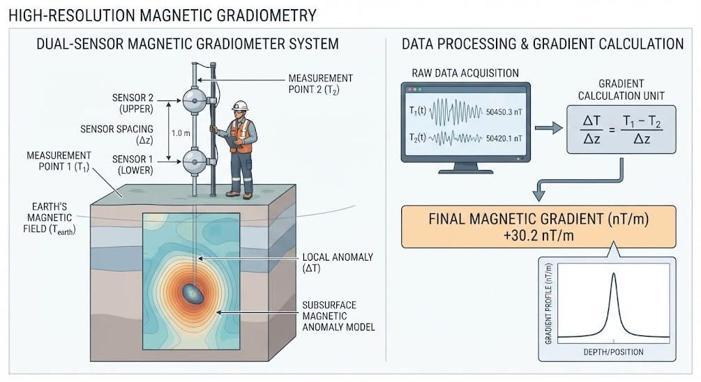
A Dual-Sensor Proton Magnetometer is a geophysical instrument that measures the Earth’s magnetic field using two proton-precession sensors. It combines total-field magnetic measurements with the ability to compare readings from two spatially separated sensors.
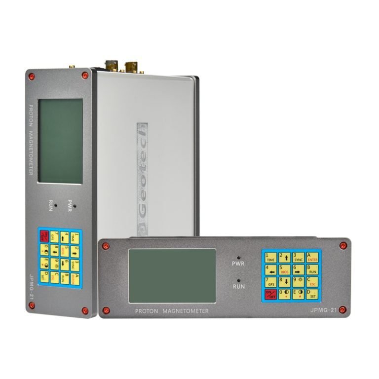
The GEOTECH JPMG dual-sensor system is designed for professional magnetic surveys in mineral exploration, archaeological investigations, environmental studies, and engineering applications. It measures magnetic field intensity and supports gradient-oriented surveys where differences between sensor readings help reveal local magnetic variations.
Unlike a single-sensor configuration, a dual-sensor system can collect two magnetic measurements at the same time. When the sensors are installed with a known separation and orientation, their readings can be used to calculate a magnetic field gradient.
This configuration is particularly useful when survey teams need to investigate local anomalies, compare magnetic field values at different heights, or reduce the influence of spatially uniform background changes.
2. Product Overview: GEOTECH JPMG Series
The JPMG series uses proton precession technology to measure magnetic field intensity. The dual-sensor configuration supports simultaneous acquisition from two sensors, while the control unit manages measurement data, operating modes, storage, and data transfer.
The product page lists a measurement range of 20,000–120,000 nT, 0.05 nT sensitivity, 0.01 nT resolution, and ±0.1 nT absolute accuracy. These specifications describe different aspects of instrument performance and should be interpreted separately.
The system is intended for field-based geomagnetic surveys where portability, measurement consistency, and flexible sensor deployment are important.
Ⅱ. How Does a Proton Magnetometer Work?
1. Proton Precession Principle
A proton magnetometer measures magnetic field intensity by detecting the precession frequency of hydrogen nuclei.
The sensor contains a hydrogen-rich proton medium. During polarization, an applied magnetic field aligns a portion of the proton magnetic moments. When the polarization field is removed, the protons precess around the ambient magnetic field direction.
The precession frequency is proportional to the magnetic field strength. The instrument measures this frequency and converts it into a magnetic field value.
The relationship is expressed as:
f=2πγpB
Where:
- f is the proton precession frequency.
- γp is the proton gyromagnetic ratio.
- B is the magnetic field strength.
For proton precession measurements, the frequency-to-field conversion is approximately 42.577 Hz per microtesla, or 0.042577 Hz per nanotesla.
This physical relationship enables proton magnetometers to provide total-field measurements without relying on a conventional fluxgate-style vector sensor.
2. From Frequency to Magnetic Field Data
A typical proton magnetometer measurement sequence includes:
- Polarizing the proton medium.
- Removing the polarization field.
- Detecting the free-precession signal.
- Estimating the signal frequency.
- Converting the frequency into magnetic field intensity.
- Recording the measurement with its associated time and position information, where available.
Measurement quality depends on signal strength, environmental magnetic noise, sensor placement, instrument timing, and the quality of frequency estimation.
The proton precession principle provides a direct physical relationship between frequency and field strength. However, the overall performance of a complete survey also depends on field procedures and data quality control.
Ⅲ. Dual-Sensor Measurement and Magnetic Gradient Surveys
1. How Dual-Sensor Measurement Works
A dual-sensor configuration measures the magnetic field at two locations simultaneously. The difference between the readings can be used to calculate the magnetic field gradient along the sensor separation direction.
For two sensors separated by a known distance:
G=dB2−B1
Where:
- G is the magnetic field gradient.
- B1 and B2 are the measured magnetic field values.
- d is the sensor separation distance.
The calculated gradient depends on sensor alignment, separation distance, calibration consistency, and the direction of the measurement baseline.
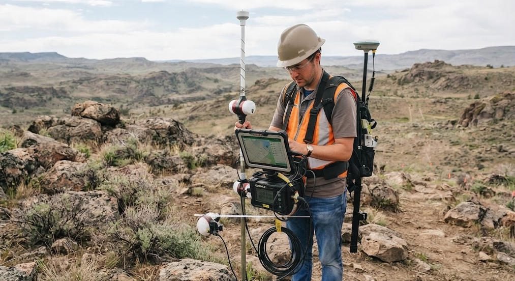
A vertical sensor arrangement measures the gradient along a vertical baseline. A horizontal arrangement measures the gradient along a horizontal baseline.
The JPMG product page identifies a dual-sensor configuration but does not establish one universal sensor separation distance for every deployment. The actual spacing and mounting arrangement should therefore be confirmed for the selected configuration.
2. Total-Field Measurement vs. Gradient Measurement
| Measurement Type | What It Measures | Typical Purpose |
|---|---|---|
| Total-field measurement | Magnetic field intensity at a sensor location | Regional magnetic mapping and anomaly surveys |
| Vertical gradient | Field difference along a vertical baseline | Near-surface anomaly characterization |
| Horizontal gradient | Field difference along a horizontal baseline | Mapping lateral magnetic changes |
| Dual-sensor comparison | Difference between simultaneous sensor readings | Gradient analysis and measurement consistency checks |
Gradient data can emphasize local spatial variations and reduce some common-mode effects when both sensors experience similar temporal changes.
However, gradient measurements do not automatically eliminate all environmental interference. Nearby cultural noise, unequal sensor responses, sensor movement, and spatially varying magnetic fields can still affect the results.
3. Why Use Two Sensors?
The main value of a dual-sensor configuration is the ability to collect two spatially separated measurements in one acquisition sequence.
Potential benefits include:
- Direct gradient measurement without relying solely on repeated single-sensor passes.
- Comparison of magnetic field values at two locations.
- Improved investigation of local anomalies where gradient information is useful.
- Additional data for quality checks and interpretation.
- Flexible sensor arrangements for different survey geometries.
The actual productivity improvement depends on survey design, sensor spacing, terrain, sampling interval, and the need for repeat measurements.
Ⅳ. Key Technical Specifications
The following specifications are listed on the GEOTECH JPMG dual-sensor product page. Confirm the final configuration and specification sheet before procurement.
1. Performance Specifications
| Parameter | Listed Specification | What It Means |
|---|---|---|
| Sensitivity | 0.05 nT | Sensitivity figure stated on the product page |
| Resolution | 0.01 nT | Smallest displayed or reported increment |
| Absolute accuracy | ±0.1 nT | Stated absolute measurement accuracy |
| Dynamic range | 20,000–120,000 nT | Listed magnetic field measurement range |
| Gradient tolerance | >5,000 nT/m | Listed gradient tolerance |
| Sampling interval | 3–60 s in Mobile Mode; 3–3,600 s in Base Mode | Selectable acquisition interval by mode |
| Internal memory | 32 MB | Internal data storage |
| Data interface | RS-232 with USB adapter | Data transfer interface |
| Operating temperature | −40°C to +55°C | Listed operating temperature range |
Important: Sensitivity, resolution, and absolute accuracy are not interchangeable. Their definitions and test conditions should be confirmed in the official technical documentation.
2. Physical Specifications
| Component | Listed Specification |
|---|---|
| Console dimensions | 220 × 70 × 175 mm |
| Console weight | 1.57 kg |
| Sensor dimensions | 140 mm length × 70 mm diameter |
| Sensor weight | 1 kg per sensor |
| Sensor configuration | Two sensors |
| Connectors | Weatherproof connectors; IP67 rating stated for connectors and casing |
The listed connector and casing rating should be verified against the exact delivered configuration and its documentation before use in severe weather or immersion-prone environments.
Ⅴ. Core Features and Field Benefits
1. High-Sensitivity Magnetic Measurement
The JPMG product page lists a sensitivity of 0.05 nT and a resolution of 0.01 nT. These values describe the instrument’s stated measurement capability, but they do not guarantee that every geological target will generate a detectable anomaly.
Actual anomaly detectability depends on the magnetic properties of the target, its depth and geometry, the surrounding geology, survey spacing, environmental noise, and data processing.
For field planning, instrument sensitivity should be considered alongside expected anomaly amplitude and survey conditions.
2. Dual-Sensor Gradient Capability
The dual-sensor arrangement supports simultaneous magnetic measurements at two locations. With a known baseline, the measurements can be used to calculate a spatial gradient.
Gradient data can help distinguish local magnetic variations from broader background trends. It can also provide additional information for mapping shallow magnetic sources and interpreting localized anomalies.
The usefulness of gradient data depends on sensor geometry and the physical characteristics of the target.
3. Multiple Operating Modes
The product page lists Mobile, Walking, and Base operating modes. It also lists selectable sampling intervals for mobile and base acquisition.
| Mode | Typical Survey Use | Key Planning Consideration |
|---|---|---|
| Mobile | Moving surveys along accessible routes | Sampling interval, speed, and positioning |
| Walking | Detailed pedestrian surveys | Station spacing, sensor stability, and terrain |
| Base | Stationary reference or monitoring measurements | Sampling interval, observation duration, and environmental stability |
The appropriate mode depends on project objectives, terrain, positioning requirements, and the spatial resolution needed.
4. Data Storage and Transfer
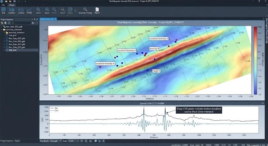
The JPMG product page lists 32 MB of internal memory and an RS-232 interface with a USB adapter. These functions support field data storage and transfer to a computer for processing and interpretation.
Before a survey, teams should confirm data formats, export compatibility, software requirements, and backup procedures.
Ⅵ. Applications of a Dual-Sensor Proton Magnetometer
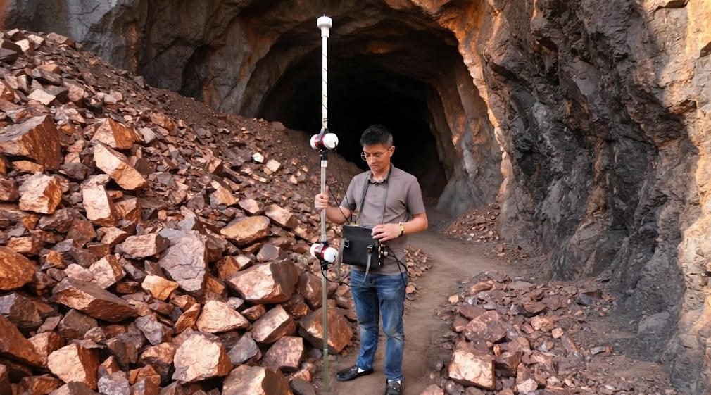
1. Mineral Exploration
Magnetic surveys help identify anomalies associated with contrasts in magnetic susceptibility or remanent magnetization between geological units.
A dual-sensor proton magnetometer can support magnetic mapping and gradient measurements in areas where local magnetic variations may help define geological contacts, intrusive bodies, structures, or magnetically responsive mineralization.
Potential applications include:
- Mapping magnetic lithological boundaries.
- Investigating iron-rich formations and magnetic mineral assemblages.
- Delineating magnetic structures and alteration-related contrasts.
- Supporting follow-up surveys before drilling.
Magnetic anomalies do not uniquely identify an ore deposit. Geological mapping, geochemical sampling, and other geophysical methods may be needed to evaluate the source of an anomaly.
2. Archaeological Prospection
Archaeological targets such as buried hearths, ditches, kilns, foundations, and ferrous objects can create local magnetic contrasts.
Gradient measurements may help emphasize small, localized anomalies in suitable survey conditions.
A typical workflow includes defining the survey grid, selecting sensor height and spacing, collecting repeatable measurements, and producing magnetic anomaly maps for archaeological interpretation.
The detectability of a buried feature depends on its magnetic contrast, size, depth, soil conditions, and nearby sources of interference.
3. Engineering and Underground Infrastructure Surveys
Magnetic surveys can help investigate ferrous objects and magnetic contrasts associated with buried infrastructure.
Potential applications include:
- Locating buried ferrous pipes and metal objects.
- Mapping magnetic anomalies near construction sites.
- Supporting preliminary investigations of underground infrastructure.
- Identifying localized magnetic disturbances for further assessment.
A proton magnetometer does not directly image all underground utilities. Non-ferrous pipes and other weakly magnetic targets may require complementary methods such as ground-penetrating radar or electromagnetic locating equipment.
4. Environmental and Geomagnetic Monitoring
Magnetic measurements can support studies of temporal and spatial changes in the magnetic field. A stationary base measurement can help characterize temporal variation during a survey.
The dual-sensor configuration can also support comparative measurements, depending on sensor arrangement and project design.
For environmental monitoring or geophysical research, teams should define the observation interval, instrument stability requirements, reference framework, and data validation procedure before deployment.
Ⅶ. Field Survey Workflow
1. Survey Planning
Before field deployment, define:
- Survey objectives and target characteristics.
- Survey area, line spacing, and station spacing.
- Expected magnetic anomaly amplitude.
- Sensor arrangement and baseline.
- Positioning requirements and sampling interval.
- Environmental interference risks.
- Data processing and interpretation requirements.
Survey geometry should be selected according to target size, depth, geological setting, and the spatial resolution required.
2. Instrument Setup and Sensor Alignment
Inspect the console, sensors, cables, connectors, and mounting hardware before measurement.
For dual-sensor gradient surveys, confirm sensor separation and alignment. Keep sensor placement consistent across survey lines, and avoid unnecessary changes to the sensor baseline during acquisition.
Check that the sensor positions and orientations are recorded accurately enough for the planned gradient calculation.
3. Data Acquisition
During field acquisition:
- Follow the instrument’s startup and measurement procedure.
- Select the appropriate operating mode and sampling interval.
- Record position and time information as required.
- Maintain consistent sensor height and separation.
- Avoid carrying ferromagnetic objects close to the sensors.
- Repeat selected measurements to assess consistency.
Where temporal magnetic variation may affect the survey, consider base-station measurements or another suitable correction procedure.
4. Quality Control and Data Processing
After acquisition, inspect the data for missing records, unusual jumps, inconsistent sensor readings, positioning errors, and possible cultural noise.
For gradient data, verify the sensor baseline and confirm that the calculation uses the correct sensor order and separation distance.
Processing may include:
- Data screening and quality checks.
- Position correction and survey-line alignment.
- Appropriate temporal correction.
- Gradient calculation.
- Magnetic anomaly mapping and profile generation.
- Comparison with geological and field observations.
Interpretation should account for survey geometry, regional background, target properties, and potential sources of interference.
Ⅷ. How to Select the Right Configuration
1. Dual-Sensor vs. Single-Sensor Proton Magnetometer
The choice between single- and dual-sensor configurations depends on whether the project requires only total-field measurements or also benefits from simultaneous differential measurements.
| Selection Factor | Single-Sensor Configuration | Dual-Sensor Configuration |
|---|---|---|
| Measurement | Total magnetic field at one location | Two simultaneous field measurements |
| Gradient survey | Requires additional setup or repeat measurements | Supports gradient calculation with a known baseline |
| Field workflow | Simpler sensor setup | Requires sensor alignment and baseline control |
| Data interpretation | Total-field anomaly mapping | Total-field and gradient-based analysis |
| Typical use | Regional mapping and general magnetic surveys | Detailed surveys requiring spatial field comparison |
The dual-sensor configuration is not automatically preferable for every project. Survey objectives, budget, field logistics, and processing requirements should guide the decision.
2. Questions to Ask Before Purchasing
Before selecting a dual-sensor proton magnetometer, confirm:
- Does the project require total-field data, gradient data, or both?
- What sensor separation and mounting arrangements are supported?
- Are the stated sensitivity and accuracy specifications supported by test documentation?
- Which operating modes and sampling intervals are available?
- What positioning and data export functions are included?
- What accessories, software, training, and technical support are available?
- What environmental conditions will the equipment encounter?
Ⅸ. Standard Configuration and Product Inquiry
1. Listed Standard Configuration
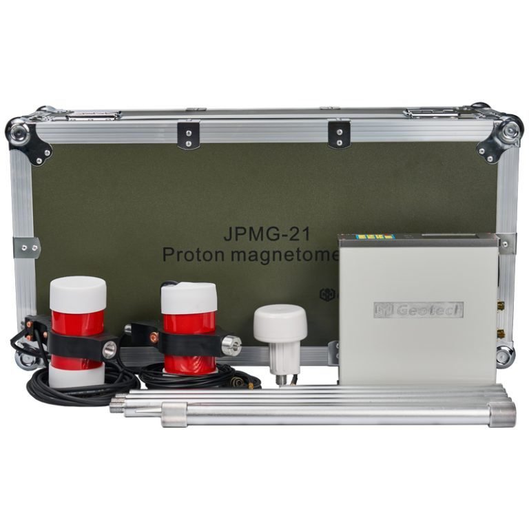
The product page lists the following standard components. Confirm the final delivery list with GEOTECH before ordering.
| Component | Quantity |
|---|---|
| JPMG proton magnetometer console | 1 |
| Sensor with cable | 2 |
| Harness / charger | 1 |
| 50 cm aluminum rods | 4 |
| Standard GPS | 1 |
| RS-232 cable with USB adapter | 1 |
| Instruction manual | 1 |
| Shipping case | 1 |
2. Request Technical Details or a Quotation
When requesting a quotation, provide the following information:
- Survey application and target type.
- Survey area and terrain.
- Required total-field or gradient measurement mode.
- Preferred sensor arrangement and baseline.
- Required sampling interval and positioning method.
- Expected environmental conditions.
- Required accessories, software, and training.
This information helps the technical team confirm the appropriate configuration and identify any project-specific requirements.
Ⅹ. Conclusion
The GEOTECH JPMG Dual-Sensor Proton Magnetometer is designed for field magnetic surveys that benefit from simultaneous measurements at two locations. Its proton precession measurement principle supports total-field magnetic measurements, while the dual-sensor arrangement enables gradient-oriented data collection when sensor geometry is controlled.
For mineral exploration, archaeological prospection, and engineering investigations, the value of a dual-sensor configuration depends on target characteristics, survey design, environmental conditions, and data quality control.
Selecting the right instrument requires more than comparing sensitivity figures. Teams should also evaluate measurement requirements, sensor arrangement, operating modes, data handling, field conditions, and technical support.
Contact GEOTECH to confirm the JPMG configuration, specifications, and accessories for your magnetic survey project.
Related Articles
| Anchor Title | Core Content (English) | URL |
|---|---|---|
| Proton Magnetometer | Overview of proton magnetometer principles, features, and applications | https://geotechcn.net/service/proton-magnetometer-insights/ |
| Proton Precession Magnetometer | Fundamentals of proton precession measurement and magnetic field detection | https://geotechcn.net/service/proton-precession-magnetometer/ |
| Proton Magnetometer Technology | Technical principles and measurement technology of proton magnetometers | https://geotechcn.net/service/proton-magnetometer-technology/ |
| Proton Magnetometer Signal Processing | Signal acquisition, frequency estimation, and data processing | https://geotechcn.net/service/proton-magnetometer-signal-processing/ |
| Proton Magnetometer Applications | Practical applications of magnetometers in geophysical exploration | https://geotechcn.net/service/magnetometer-applications-in-geophysical/ |
| Single-Sensor Proton Magnetometer | Product details and specifications for the single-sensor JPMG configuration | https://geotechcn.net/products/magnetic-instrument/proton-magnetometer-single/ |
| Magnetic Instrument Catalog | Product category and magnetic survey instrument selection | https://geotechcn.net/products/magnetic-instrument/ |
Reference Sources
| Title | Core Content (English) | URL |
|---|---|---|
| Society of Exploration Geophysicists (SEG) | Professional resources on exploration geophysics, magnetic methods, and geophysical interpretation | https://seg.org/ |
| U.S. Geological Survey (USGS) | Geological and geophysical research, including magnetic field data and mineral resource investigations | https://www.usgs.gov/ |
| NOAA National Centers for Environmental Information | Geomagnetic data, magnetic field models, and geomagnetic reference information | https://www.ncei.noaa.gov/ |
| Encyclopaedia Britannica — Proton-Precession Magnetometer | Overview of the proton-precession magnetometer and its measurement principle | https://www.britannica.com/technology/proton-precession-magnetometer |
| European Geological Surveys | Geological survey information and geoscience resources across Europe | https://www.eurogeosurveys.org/ |
FAQ
Q1. What is a dual-sensor proton magnetometer?
A dual-sensor proton magnetometer uses two proton-precession sensors to measure magnetic field intensity at two locations simultaneously. The readings can be compared to calculate a magnetic gradient when sensor spacing and alignment are known. It is used in mineral exploration, archaeology, and engineering surveys where spatial magnetic variations are important.
Q2. What is the advantage of a dual-sensor proton magnetometer over a single-sensor model?
A dual-sensor configuration captures two magnetic field measurements in the same acquisition sequence and can support gradient calculations. This may reduce the need for separate measurement passes in some survey designs. The actual efficiency gain depends on survey geometry, terrain, sensor spacing, and data processing requirements.
Q3. What is the difference between sensitivity, resolution, and accuracy?
Sensitivity describes the ability to respond to small magnetic field changes under defined conditions. Resolution refers to the smallest measurement increment that can be represented. Accuracy describes how closely a measurement agrees with the reference value. These metrics are different and should be evaluated using the manufacturer’s definitions and test conditions.
Q4. Can a dual-sensor proton magnetometer detect underground minerals?
A proton magnetometer measures magnetic field variations associated with contrasts in the magnetic properties of subsurface materials. It can help identify anomalies related to magnetic mineralization and geological structures. However, a magnetic anomaly does not uniquely identify a mineral deposit. Geological and complementary geophysical investigations may be required.
Q5. What should I consider when selecting a dual-sensor proton magnetometer?
Consider whether the survey requires total-field measurements, gradient data, or both. Review the instrument’s measurement range, sensitivity, resolution, accuracy, sensor spacing, operating modes, positioning, data export, and environmental specifications. Also confirm the required accessories, software, technical support, and field operating conditions before purchasing.