Welcome to Geotech!
-1.png)


Shallow Underground Detection: Geophysics for Urban Safety
TIPS: With the acceleration of new urbanization, shallow underground space detection technology has become the core support for urban safety development. The General Prospecting Institute of China National Administration of Coal Geology has been deeply engaged in geophysical exploration technology for many years. Addressing key issues such as urban road safety hazard detection, pipeline detection, coal seam structure fine detection, and safe utilization of underground space, the institute has formed a high-precision detection technology system for 0-200 meter shallow underground space. Road cavity detection accuracy has improved from 20% to over 70%, with some areas exceeding 90%.
Ⅰ. Overview and Development Background
1. Strategic Significance of Urban Underground Space Development
Urban underground space is an important resource for city development with non-renewable characteristics. As urbanization accelerates and surface space becomes increasingly scarce, utilizing underground space has become inevitable for sustainable urban development. However, underground development faces multiple geological hazards including karst, faults, and goaf areas. Accurate detection is the prerequisite for safe utilization.
The General Prospecting Institute has systematically researched urban road safety hazard detection and prevention, pipeline detection, coal seam structure and abnormal geological body fine detection, and safe underground space utilization, establishing a complete 0-200 meter shallow underground space high-precision detection technology system.
2. Technical Development and Breakthroughs
Traditional underground detection methods had limitations including low accuracy, slow efficiency, and weak anti-interference capability. Through technological innovation, the institute has achieved multiple key breakthroughs:
- Road cavity detection accuracy improved from 20% to over 70%, with some areas exceeding 90%
- Established multi-method joint detection system for 0-200 meter depth range
- Developed ultra-shallow transient electromagnetic detection for karst fine detection
- Formed integrated fiber optic monitoring and early warning solution
Ⅱ. Core Geophysical Technology System
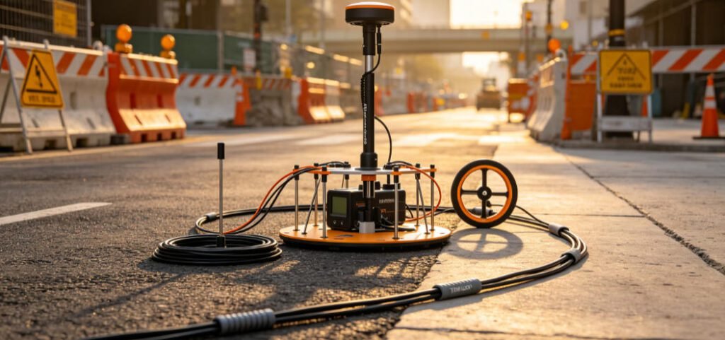
1. High-Density Electrical Method
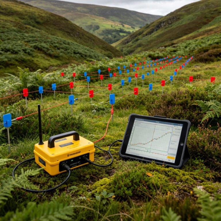
High-density electrical method integrates electrical sounding and electrical profiling into an array-based exploration method. By deploying dozens to hundreds of electrodes at once, rapid automatic acquisition is achieved through programmed electrode switching devices. This method features large information volume, high observation accuracy, and flexible detection depth:
- Detection depth: 0-100 meters, vertical resolution: 5-10 meters
- Quaternary structure and active fault detection
- Shallow electrical structure and groundwater distribution identification
- Concealed fault structure fine recognition
2. Ground Penetrating Radar (GPR)
GPR transmits high-frequency electromagnetic waves underground through transmitting antennas. When encountering wave impedance interfaces, reflected waves are formed and recorded by receiving antennas to create radar image profiles. This technology features high precision and resolution:
- Detection depth: 0-20 meters, resolution: 0.5-1 meter
- Shallow non-metallic pipeline detection
- Abnormal geological body (cavities, loose bodies) precise identification
- Road disease rapid detection
3. Transient Electromagnetic Method (TEM)
TEM utilizes ungrounded loops to send primary pulse electromagnetic fields to the underground, measuring secondary field changes during the primary field interval. This method is sensitive to low-resistance bodies with strong anti-interference capability:
- Ultra-shallow TEM specifically for karst fine detection
- Underground pipeline and space structure detection
- Urban karst and water-rich area effective identification
- Opposing Coils TEM (OCTEM) with outstanding anti-interference capability
4. Shallow Seismic and Microtremor Survey
Shallow reflection seismic analyzes reflected signals from artificially excited seismic waves to obtain underground structure information. Microtremor survey extracts Rayleigh wave dispersion curves from natural microtremor signals to invert underground S-wave velocity structure:
- Shallow reflection seismic: 50-200 meters depth, 5-10 meters vertical resolution
- Microtremor survey: 30-100 meters depth, suitable for urban bedrock fracture zones
- Active source surface wave: 0-40 meters depth, strong lithology layering capability
- Combined application effectively identifies fault structures and breakpoint tracking
5. Multi-Method Joint Detection Strategy
Single geophysical methods have ambiguity and limitations. Practical work requires multi-method joint detection:
- High-density electrical + microtremor: complementary verification of electrical and velocity structures
- GPR + TEM: shallow fine structure combined with deep low-resistance anomalies
- Shallow seismic + drilling verification: seismic profiles calibrated with core data
- OCTEM + microtremor: concealed fault identification in strong urban interference environments
Ⅲ. Typical Application Scenarios and Case Studies
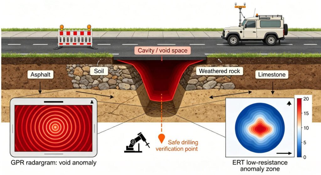
1. Urban Road Safety Hazard Detection
Urban road collapse is a significant threat to public safety. The institute has established a road cavity rapid detection technology system using GPR, high-density electrical method, and TEM:
- GPR rapid scanning for 5 meters below road surface
- High-density electrical method identifying deep loose bodies and water-rich zones
- TEM detecting karst development areas
- Comprehensive accuracy improved from 20% to over 70%, some areas exceeding 90%
2. Underground Pipeline Fine Detection
Urban underground pipelines are the lifeline of city operation. Differentiated detection strategies are adopted for different materials and burial depths:
- Metal pipelines: electromagnetic induction method, clamp method for precise positioning
- Non-metallic pipelines: GPR method, seismic imaging method
- Deep large-diameter pipelines: high-density resistivity method
- Complex areas: multi-method comprehensive detection, large before small, shallow before deep
3. Coal Seam Structure and Goaf Detection
Coal mine goaf areas are important hazards for urban construction and mine safety. Technologies include 3D seismic, TEM, and Ground Polarization Tomography (GPTS):
- 3D seismic determining general goaf locations
- TEM identifying water-filled goaf low-resistance anomalies
- GPTS technology with 10-meter precision for abnormal zone positioning
- Providing guarantee for coal mine safety production and urban construction
4. Karst and Abnormal Geological Body Detection
Karst ground collapse has concealment and suddenness, representing a major threat to urban underground space development. Comprehensive detection solutions include:
- GPR: shallow soil disturbance detection
- Small electrode spacing high-density electrical: overburden thickness and structure detection
- Shallow seismic + microtremor: karst development characteristic detection
- Cross-hole tomography: fracture zones and karst caves fine identification
5. Geothermal New Energy Geophysical Exploration
Geothermal resource exploration is an important application field of geophysical technology. By measuring physical property changes of underground materials, heat storage areas are located:
- Gravity exploration: detecting fault zones and special rock mass distribution
- Magnetic method: delineating magmatic rock ranges, identifying heat source areas
- Electrical method: utilizing hot water’s high conductivity and low resistivity to find thermal reservoirs
- Seismic exploration: identifying formation fractures and heat storage space structures
Ⅳ. Fiber Optic Monitoring and Early Warning Technology
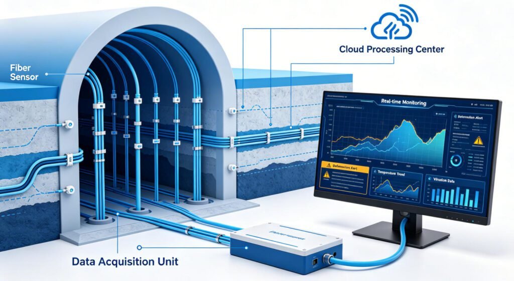
1. Technical Principles and System Composition
For monitoring needs in foundation pits, tunnels, slopes, mining, and geological environment restoration, the institute has developed a fiber optic sensing monitoring technology system. This technology uses optical fiber as sensing elements, perceiving formation deformation, temperature, vibration, and other parameters through measuring optical signal changes.
2. Core Technical Methods
- Distributed fiber optic strain monitoring: real-time formation deformation sensing
- Fiber optic temperature monitoring: identifying seepage and heat source anomalies
- Fiber optic vibration sensing: monitoring microseisms and structural vibrations
- Full formation deformation monitoring and stability evaluation
3. Application Advantages
- Distributed measurement: one fiber can monitor several kilometers
- High precision: strain resolution reaches microstrain level
- Real-time capability: continuous monitoring with timely early warning
- Long lifespan: fiber is corrosion-resistant, suitable for harsh environments
Ⅴ. Technical Innovation and Core Competitiveness
1. Methodology Innovation
Established a 0-200 meter shallow underground space full-element detection technology system, achieving the leap from single method to multi-method joint detection, and from static detection to dynamic monitoring:
- Multi-method fusion: electromagnetic, seismic, optical and other multi-physics field joint application
- Multi-scale detection: from centimeter-level pipelines to hundred-meter-level structures
- Multi-dimensional monitoring: surface, borehole, and roadway立体化 observation
2. Equipment Development Innovation
Independently developed series of specialized equipment, improving detection efficiency and accuracy:
- Ultra-shallow transient electromagnetic system: specialized for karst fine detection
- Distributed fiber optic monitoring system: long-distance real-time monitoring
- 3D ground penetrating radar: true 3D acquisition and processing
- Intelligent data processing platform: AI-assisted anomaly identification
3. Application Model Innovation
Formed a full-chain service model of “detection-monitoring-early warning-governance”:
- Preliminary detection: identifying geological hazard distribution
- Construction monitoring: real-time engineering impact assessment
- Operation early warning: long-term safety status monitoring
- Governance evaluation: scientific assessment of remediation effects
Ⅵ. Industry Development Trends and Prospects
1. Technical Development Trends
- Intelligent: AI deep learning empowering data interpretation, automatic anomaly identification
- Refined: 3D and 4D detection technology popularization, dynamic monitoring becoming normal
- Green: non-destructive detection and environmentally friendly construction becoming industry standards
- Integrated: full-chain integration of detection-monitoring-early warning-governance
2. Application Expansion Directions
- Urban underground space resource full-element survey and evaluation
- Geothermal new energy refined exploration and development monitoring
- Mine mining space safety perception and risk early warning
- Major engineering geological safety guarantee full-process service
3. Standard System Construction
Promoting the establishment of urban underground space detection technology standard systems, including:
- Detection method selection and optimization design specifications
- Data acquisition and quality control standards
- Data processing and interpretation technical procedures
- Result acceptance and application evaluation guidelines
Ⅶ. Conclusion
Shallow underground space detection technology is an important support for ensuring urban safety and promoting rational resource utilization. The General Prospecting Institute of China National Administration of Coal Geology will continue to deepen geophysical technology innovation, improve the 0-200 meter shallow underground space high-precision detection technology system, expand geothermal new energy geophysical exploration applications, and provide stronger technical guarantees for safe and efficient urban underground space utilization, mine safety production, and ecological civilization construction.
Reference Sources
| Organization | Citation Content | URL |
|---|---|---|
| Chinese Academy of Geological Sciences | Urban Underground Space Detection Technology Innovation and Safety Warning Engineering | https://www.cags.cgs.gov.cn/ |
| China Geological Survey | Xiong’an New Area Deep 3D Geological Structure Detection and Geothermal Clean Energy Survey | https://www.cgs.gov.cn/ |
| National Center for Geological Exploration Technology | Research on Urban Geophysical Exploration Methods Application Progress | http://www.progeophys.cn/ |
| China National Administration of Coal Geology | Shallow Underground Space Detection and Monitoring Technology System | http://kczy.ccgc.cn/ |
| China Urban Geological Survey Project | Research on Urban Underground Space Resource Detection and Evaluation Technology System | https://www.hddz.cgsnjzx.cn/ |
FAQ
Q1: What is the main application depth range of shallow underground space detection technology?
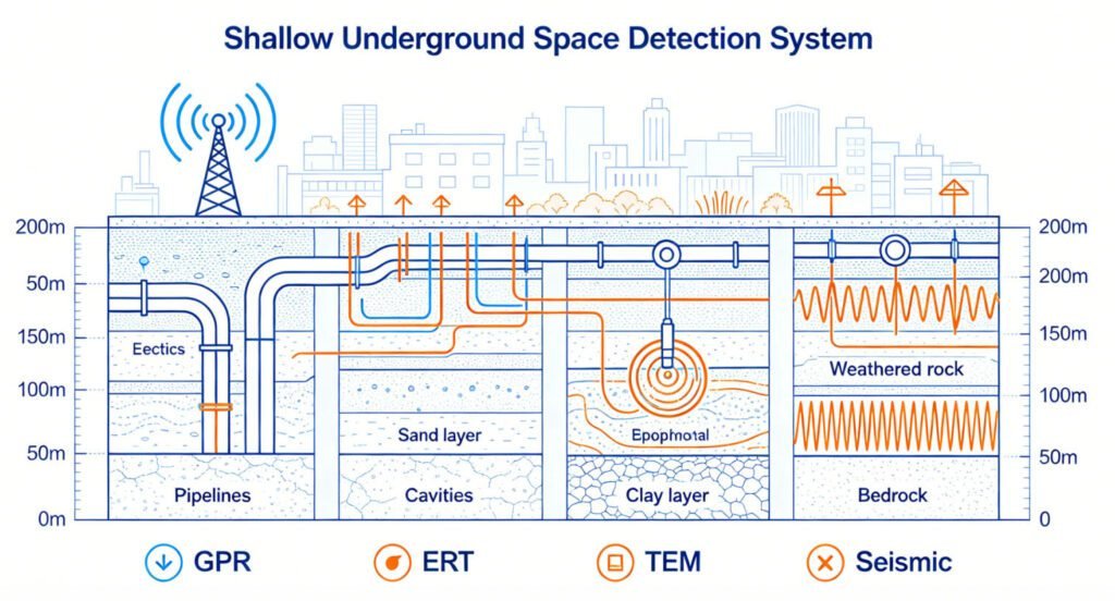
The high-precision detection technology system developed by the General Prospecting Institute of China National Administration of Coal Geology primarily covers the 0-200 meter depth range. GPR is suitable for 0-20 meter shallow fine detection; high-density electrical method and active source surface wave are applicable for 0-100 meters; shallow reflection seismic and microtremor survey can extend to 200 meters. Different method combinations can achieve full depth coverage.
Q2: What are the advantages of multi-method joint detection compared to single methods?
A: Single geophysical methods have ambiguity and limitations. Multi-method joint detection effectively reduces interpretation uncertainty through complementary verification of electromagnetic, seismic, optical and other multi-physics field information. For example, high-density electrical method provides electrical structure while microtremor survey provides velocity structure; their combination more accurately identifies fault fracture zones. Practical cases show that joint detection improved road cavity accuracy from 20% to over 70%, with some areas exceeding 90%.
Q3: How does fiber optic monitoring technology achieve underground space safety early warning?
A: Distributed fiber optic monitoring technology deploys optical fibers as sensing elements in underground spaces, perceiving formation strain, temperature, vibration and other parameters by measuring backscattered optical signal changes. When monitoring data exceeds preset thresholds, the system automatically triggers early warnings. This technology features distributed measurement, long distance, high precision, and real-time capability. One fiber can monitor several kilometers with microstrain-level strain resolution, suitable for long-term safety monitoring of foundation pits, tunnels, and slopes.
Q4: How is geophysical technology applied in geothermal new energy exploration?
A: Geothermal exploration mainly uses geophysical technology to identify geological anomalies related to heat sources, heat channels, and thermal reservoirs. Gravity exploration detects fault zones and rock mass distribution; magnetic method delineates magmatic rock ranges; electrical method utilizes hot water’s high conductivity and low resistivity to identify thermal reservoir areas; seismic exploration identifies heat storage space structures. Multi-method synthesis can precisely locate geothermal target areas, reduce drilling risks, and improve exploration success rates.
Q5: How is detection accuracy ensured in strong urban interference environments?
A: Urban environments present electromagnetic interference, building obstruction, traffic vibration and other unfavorable factors. Countermeasures include: selecting methods with strong anti-interference capability, such as Opposing Coils TEM (OCTEM) which measures pure secondary fields in zero magnetic flux planes to effectively suppress interference; adopting microtremor survey using natural microtremor signals without artificial sources; optimizing acquisition parameters such as increasing stacking times and selecting appropriate observation windows; multi-method joint verification to mutually confirm and improve result reliability.