Welcome to Geotech!

EXPONOR 2026: Atacama Geophysics Tech Preview
TIPS:EXPONOR 2026 opens June 8–11 in Antofagasta, Chile’s mining capital. Over 1,200 exhibitors and 45,000 visitors will converge at the world’s leading copper and lithium production hub. This report examines how DC resistivity sounding and electrical imaging technologies are transforming exploration in the Atacama Desert. Discover why DC resistivity sounding now dominates deep-target detection in Chile’s porphyry copper belt. Learn how electrical imaging integration with AI is cutting exploration costs by 40% for major miners.
Ⅰ. Introduction
EXPONOR 2026 opens on June 8 at the AIA Exhibition Grounds in Antofagasta, Chile. The show runs through June 11. It is one of the world’s three largest mining exhibitions. The Antofagasta Industrial Association (AIA) organizes it. This is the 21st edition.
The 2024 edition hosted 1,146 exhibitors from 32 countries. It attracted 47,000 visitors from 57 countries. Business volume reached $940 million. The 2026 edition projects 1,200 exhibitors, 45,000 visitors, and 30 participating countries. Canada is the Guest Country of Honor.
Antofagasta is Chile’s mining capital. The region produces 54% of national copper and 100% of lithium. It hosts $83 billion in planned projects through 2033. This is the largest project pipeline in a decade. BHP’s $14 billion investment to boost copper production leads the list. CODELCO’s Chuquicamata Underground Mine ($4.429 billion) and Radomiro Tomic expansion ($6.672 billion) follow.
For geophysical exploration companies, this concentration creates unmatched opportunity. Modern DC resistivity sounding, electrical imaging, and induced polarization systems now map ore bodies beneath the Atacama Desert’s thick cover. They reduce dry holes. They cut costs. They align with strict ESG mandates.
Geotech Instrument Co., Ltd. designs instruments for these exact challenges. This article previews the geophysics technologies that will dominate EXPONOR 2026 discussions.
Ⅱ. The Atacama Exploration Landscape in 2026
1.Copper and Lithium Dominance
Chile is the world’s leading copper producer. Output reached 5.5 million tonnes in 2024. This is up nearly 5% from 2023. Mining contributes over 14% of GDP. It accounts for approximately 60% of exports.
Exploration investment exceeded $790 million in 2024. Copper exploration alone attracted $636 million. This represents 27% of global exploration spend. The country holds 51 mining projects valued at over $83 billion through 2033.
The lithium triangle—encompassing Chile, Argentina, and Bolivia—supplies most of the world’s lithium. Chile’s Salar de Atacama is the largest and highest-grade source. SQM and Albemarle operate massive brine extraction facilities. EXPONOR 2026’s strategic partners include both companies.
2.The Deep-Cover Challenge
The Atacama Desert hides much of Chile’s mineral wealth beneath thick cover. Alluvial deposits, salar evaporites, and volcanic sequences blanket extensive areas. This cover obscures surface indicators. Traditional mapping fails here.
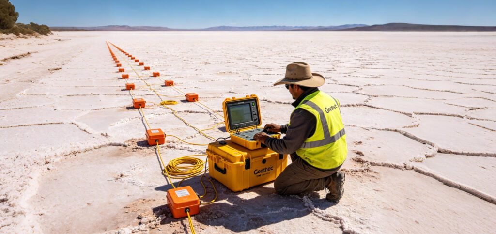
Geophysical methods are the only solution. DC resistivity sounding maps conductive brine aquifers and alteration zones. Electrical imaging creates 2D and 3D pictures of subsurface structure. Induced polarization detects disseminated sulfides at depth. These methods see through cover that stops all other exploration tools.
The Montero Mining Potrero project demonstrates this approach. The company completed 28 line-kilometers of IP and resistivity surveying in December 2025 and January 2026. They used pole-dipole arrays with 200-meter dipole spacing. The data refined their understanding of a hydrothermal gold system in the Maricunga Belt. AI-assisted modeling now guides their next drill phase.
Ⅲ. Key Geophysical Technologies at EXPONOR 2026
1.DC Resistivity Sounding (VES)
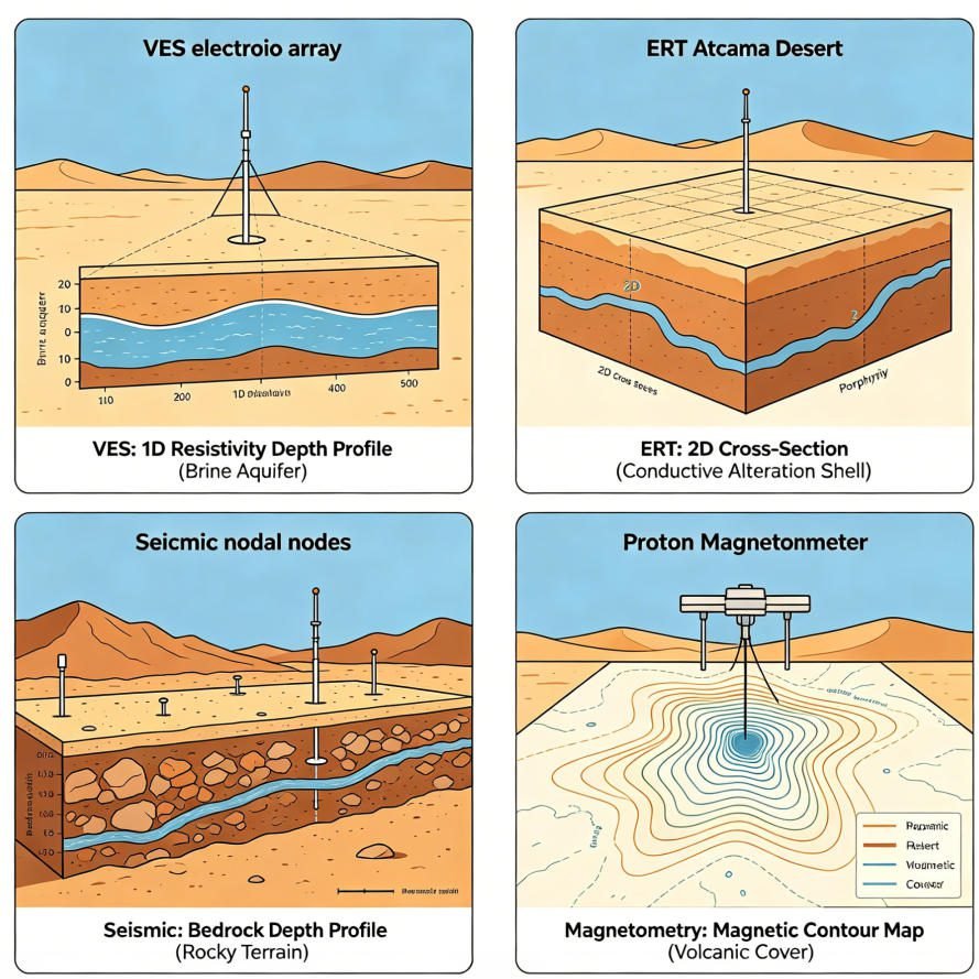
DC resistivity sounding, also called vertical electrical sounding (VES), measures apparent resistivity at increasing electrode spacings. It creates a 1D resistivity profile with depth. This reveals layer boundaries, water tables, and conductive anomalies.
For Atacama exploration, VES serves critical functions:
- Mapping salar brine aquifers for lithium extraction
- Detecting conductive alteration halos around porphyry copper systems
- Delineating groundwater systems for environmental baseline studies
- Monitoring tailings dam integrity in arid conditions
Modern VES systems use Schlumberger, Wenner, or dipole-dipole configurations. Multi-channel instruments collect data at multiple spacings simultaneously. Inversion software converts apparent resistivity to true resistivity versus depth. Processing takes minutes.
At EXPONOR 2026, expect VES systems integrated with GPS and real-time visualization. Field teams upload data via satellite link. Inversion runs on cloud servers. Results return within hours. This speed matters when daily field costs in the Atacama exceed $8,000.
2.Electrical Imaging (ERT)
Electrical imaging, also called electrical resistivity tomography (ERT), builds on VES principles. It deploys electrode arrays along profiles or grids. It measures thousands of combinations to create 2D cross-sections or 3D volumes.
The method excels at mapping lateral variations. A single ERT line can reveal fault offsets, dyke intrusions, and alteration zones. Grid surveys create plan-view slices at multiple depths. This is essential for complex porphyry systems where mineralization spreads in three dimensions.
In Chile’s porphyry copper belt, ERT maps the “shell” of conductive alteration around ore bodies. It distinguishes argillic from phyllic alteration. It identifies structural controls on mineralization. It guides drill targeting with precision that VES alone cannot match.
The Geotech GIM Series handles these demands. It supports 1D VES, 2D ERT, and 3D grid acquisitions in one platform. Ten-channel synchronous acquisition speeds up data collection. Rolling measurement mode covers long profiles without stopping.
3.Induced Polarization (IP)
IP measures the delayed voltage response after current shutoff. This chargeability indicates disseminated sulfides, clays, or graphite. In mining exploration, IP is the primary tool for finding porphyry copper and VMS deposits.
The Atacama context makes IP essential. Magnetic methods struggle with thick cover and magnetic destruction zones above ore bodies. IP penetrates these challenges. It detects chargeable minerals at depth.
Spectral IP advances are reshaping the field. Full-spectrum chargeability analysis distinguishes ore types. Frequency-domain IP offers faster acquisition than traditional time-domain methods. High-density 3D grids improve resolution for complex targets.
At the Potrero project, IP surveys identified stockwork veining zones with 6–7 veinlets per meter. These zones correlate with porphyry-style hydrothermal systems. The IP data, combined with reprocessed magnetic data and geological mapping, now guide drill targeting.
4.Seismic Nodal Systems
Seismic exploration has evolved. Traditional systems required heavy cables and large crews. Nodal systems eliminate cables entirely. Each node is a self-contained digital recorder. It stores data internally. It requires no interconnection.
This architecture transforms Atacama logistics. Crews deploy nodes by hand on rocky desert terrain. They retrieve them days later. Download is wireless. Battery life extends to 30+ days. Some systems operate continuously for months.
For deep mineral exploration, nodal seismic reaches 500+ meters. It maps bedrock topography beneath thick salar sequences. It identifies fault structures that control brine migration and ore deposition. Low-power designs suit remote Atacama sites where generator fuel is expensive.
5.Proton Magnetometers
Proton precession magnetometers measure Earth’s magnetic field with high precision. They detect magnetic minerals like magnetite and pyrrhotite. These minerals often associate with copper, iron, and gold systems.
Modern proton magnetometers are lightweight and GPS-integrated. Some weigh under 2 kg. They log position and magnetic data simultaneously. Post-processing creates contour maps of magnetic anomalies.
In Chile, magnetometers map the structural framework of porphyry systems. They identify magnetic destruction zones above ore bodies. They trace dike swarms that feed mineralization. They also serve engineering applications like locating buried infrastructure near mine sites.
6.Ground Penetrating Radar (GPR)
GPR uses high-frequency electromagnetic pulses. It images shallow structures with centimeter-scale resolution. Depth penetration ranges from 1 to 30 meters.
For Atacama mining, GPR maps:
- Near-surface fracture networks in bedrock
- Roadbed and foundation integrity at remote camps
- Tailings dam internal structure and moisture zones
- Salar crust thickness above brine aquifers
GPR complements deeper methods. It resolves shallow detail that DC resistivity sounding and IP miss. It also guides drill collar placement to avoid near-surface hazards like voids or loose alluvium.
Ⅳ. Integration Trends: Multi-Parameter Surveys
1.Why Single Methods Fall Short
No single geophysical method solves every Atacama problem. VES gives depth but no lateral detail. ERT maps structure but cannot distinguish ore clay from alteration clay. IP detects sulfides but misses oxide copper. Magnetics maps iron minerals but fails in thick cover. GPR resolves shallow detail but lacks depth.
This ambiguity drives false positives. It wastes drill meters. It frustrates exploration budgets in a high-cost environment.
2.The Multi-Parameter Solution
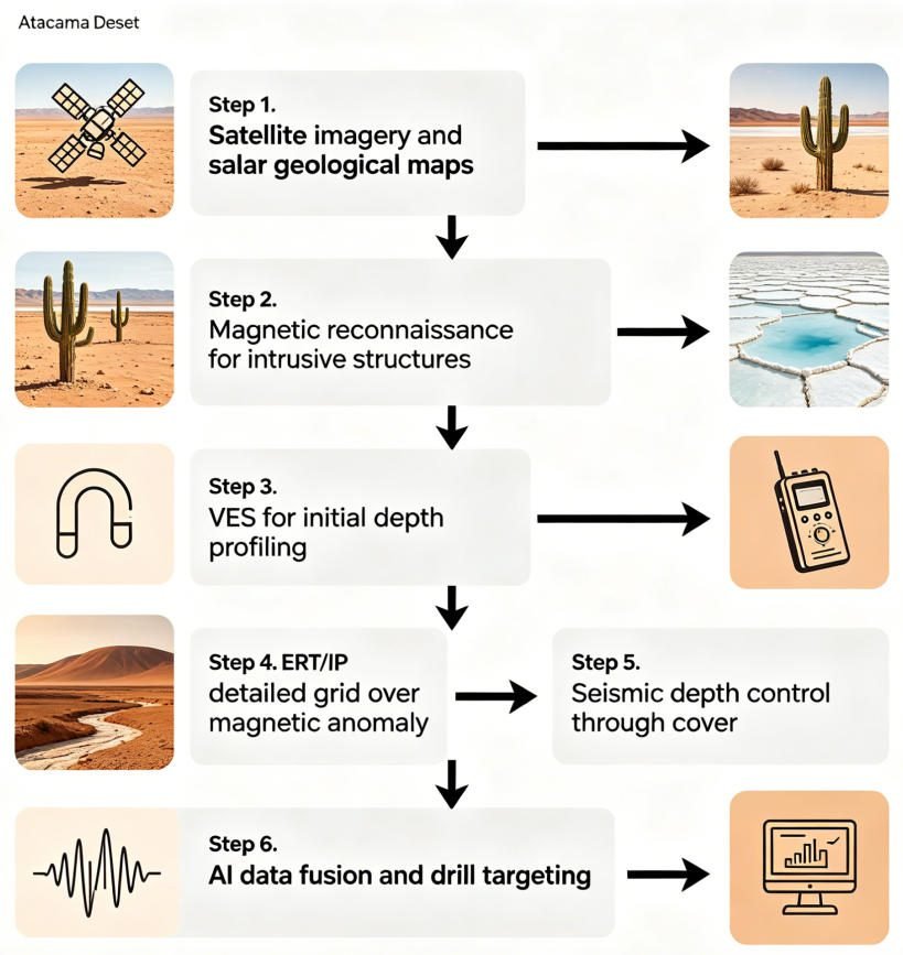
Combining methods reduces uncertainty. A typical integrated Atacama survey might include:
- Magnetics for regional structure and intrusive body mapping
- VES for initial depth-to-bedrock and water table estimates
- ERT for conductive alteration halo delineation
- IP for sulfide identification within halos
- Seismic for detailed depth-to-bedrock and structural control
Data fusion platforms merge these datasets. AI algorithms identify anomalies that satisfy multiple physical criteria. The result is sharper targeting. Drilling success rates improve significantly.
At the Potrero project, Montero Mining combined reprocessed 2012 magnetic data with new IP and resistivity surveys. They added detailed geological mapping and high-resolution geochemistry. AI-assisted modeling now integrates all datasets into 3D visualization. This systematic approach replaces isolated anomaly chasing.
At EXPONOR 2026, expect IP-ERT integration to dominate technical discussions. Equipment manufacturers now bundle multi-method systems in single chassis. The Geotech GIM Series, for example, performs DC resistivity sounding, electrical imaging, IP, and spontaneous potential surveys in one deployment.
Ⅴ. Geotech’s Solutions for Atacama Exploration
1.GIM Series: VES, ERT, and IP Integration
The Geotech GIM Series combines DC resistivity sounding, electrical imaging, and induced polarization in one platform. It supports 1D VES, 2D ERT, and 3D grid acquisitions. Key specifications include:
- 24-bit A/D conversion for microvolt resolution
- 10-channel synchronous acquisition
- Bi-directional cascading for 1,500-meter depth penetration
- IP67 waterproof rating
- Operating range: -20°C to +60°C
The GIM Series handles Atacama field conditions. Dust seals protect connectors in desert environments. Wide temperature tolerance suits hot days and cold nights. The rolling measurement mode covers long profiles without rewiring. Data exports to Res2DInv, EarthImager, and other standard software.
For Atacama mining clients, the GIM Series offers specific advantages. High-density IP arrays detect disseminated sulfides at low concentrations. Multi-channel acquisition reduces survey time by 60% compared to single-channel systems. This efficiency matters when daily field costs in remote Chile exceed $8,000.
2.Proton Magnetometer Series
Geotech’s proton precession magnetometers deliver ±0.5 nT accuracy. They feature GPS integration and automatic data logging. Internal storage holds 100,000+ readings. USB and Bluetooth export simplify data transfer.
These instruments suit Atacama exploration programs. They operate for 16 hours on rechargeable batteries. Solar charging kits extend deployment at remote sites. The compact design fits in standard airline luggage. This reduces freight costs for international projects flying into Santiago or Antofagasta.
3.Seismic Nodal and GPR Systems
Geotech’s seismic nodal systems offer cable-free acquisition. Each node records independently. Deployment requires no heavy vehicles. A crew of two can lay 100 nodes per day on rocky desert terrain. Data download is wireless via tablet interface.
Our GPR systems provide high-resolution shallow imaging. They use shielded antennas to minimize air-wave interference. Real-time display shows subsurface features as the operator walks. Digital filtering removes noise from power lines and radio towers.
4.Software and Support
Geotech provides more than hardware. We offer:
- Training programs for Chilean field crews and data processors
- Technical support via email, phone, and video call in Spanish and English
- Custom survey design for specific Atacama geological targets
- Data processing services for clients without in-house expertise
This support ecosystem matters in Chile. Local universities produce geoscience graduates. But practical training in modern instrumentation is scarce. Geotech fills this gap. We partner with Chilean mining departments and exploration companies. We build local capacity.
Ⅵ. Sustainability and ESG Compliance
1.Low-Impact Exploration
Environmental, social, and governance (ESG) standards now govern mining investment. Chile’s Ministry of Mining emphasizes responsible exploration. EXPONOR 2026’s theme is “Innovative Solutions for Sustainable Industries.”
Geophysical methods support these goals. Electrical and magnetic surveys require no excavation. They disturb no vegetation. They generate no tailings. A single VES station replaces dozens of test pits. This reduces land disturbance by 90% compared to grid drilling.
EXPONOR 2026 has signed a carbon neutrality agreement with Colbún. The event will offset its carbon footprint through bonds equivalent to planting 76,000 trees. Over 8,000 tonnes of CO2 emissions will be removed during 2026.
2.Carbon Footprint Reduction
Seismic nodal systems cut fuel consumption. Cable-free deployment needs no heavy vehicles. Solar charging eliminates generator runtime. Some nodal systems operate for months on internal batteries.
Data integration also helps. AI targeting reduces the number of drill holes needed. Fewer holes mean less fuel, less water, and less waste. This aligns with Scope 3 emissions reduction targets that major miners like BHP and CODELCO now report.
3.Community Relations
Geophysical surveys are quiet. They create no dust. They operate without blasting. This minimizes community disruption. In Chile’s socially sensitive mining regions, this can mean the difference between project approval and conflict.
The Energy Pavilion at EXPONOR 2026 addresses these intersections. It focuses on renewable energy, green hydrogen, and electromobility integration with mining operations. Geophysical service providers will highlight ESG benefits in their presentations.
Ⅶ. What to Expect at EXPONOR 2026
1.Exhibition Scale
EXPONOR 2026 projects:
- 1,200 exhibitors from 30+ countries
- 45,000 visitors from 57 countries
- 16 international pavilions
- Canada as Guest Country of Honor
- $940+ million in projected business volume
The 2024 edition achieved 1,146 exhibitors and 47,000 visitors. The 2026 edition builds on this momentum. New features include the #EstaremosEnExponor program for 50 Chilean SMEs. This initiative connects small suppliers with major mining companies.
2.Strategic Partners
Major mining companies partner with EXPONOR 2026:
- Albemarle
- Antofagasta Minerals
- Capstone Copper
- CODELCO
- El Abra
- Escondida (BHP)
- Glencore
- Pampa Norte (BHP)
- Sierra Gorda SCM
- SQM
These companies drive procurement decisions. Their supply chain managers attend business roundtables. Their technical teams evaluate new instruments. For geophysical equipment suppliers, access to these decision-makers is the primary value of exhibiting.
3.Technical Program
The exhibition includes:
- Seminars on industry-relevant topics
- Business roundtables between mining executives and suppliers
- Technical talks on exhibited products and services
- Field visits to mining operations
- Networking sessions with procurement and contracts managers
In 2024, the event hosted 2,800 business roundtable meetings. Thirteen industry seminars and 124 technical talks ran concurrently. Eight mine site visits gave hands-on context.
4.International Pavilions
EXPONOR 2026 consolidates international participation:
- Swiss Pavilion (90 m², 9 booths)
- Canadian Pavilion (Guest Country)
- EU Zone (new for 2026)
- US Pavilion
- China Pavilion
- Germany Pavilion
- Argentina Pavilion
These pavilions create concentrated zones for technology transfer. Geophysical instrument manufacturers typically cluster in the Swiss, German, or US pavilions.
Ⅷ. Planning Your Visit
1.Registration
Register at www.exponor.cl. Standard visitor entry is free. Business packages include roundtable access and networking events. Contact reservas@exponor.cl for stand reservations.
2.Travel Logistics
Cerro Moreno International Airport (ANF) serves Antofagasta. It is 15 minutes from the AIA Exhibition Grounds. Santiago connects to Antofagasta with multiple daily flights. The Atacama Desert climate is extreme. Day temperatures reach 25°C. Night temperatures drop to 5°C. Sun protection is essential.
Ⅸ. Conclusion
EXPONOR 2026 arrives at a pivotal moment for Chilean mining. The country leads global copper and lithium production. Exploration investment is at decade highs. Technology adoption is accelerating. DC resistivity sounding and electrical imaging sit at the intersection of these trends.
These methods now deliver results that were impossible a decade ago. They see through Atacama cover. They distinguish ore from false anomalies. They reduce environmental impact. Multi-parameter integration and AI interpretation further sharpen targeting.
For exploration teams operating in Chile, EXPONOR 2026 is the place to evaluate these technologies. Compare instruments. Attend seminars. Meet suppliers. Build partnerships that will shape the next decade of Andean mineral discovery.
FAQ
Q1: When and where is EXPONOR 2026 taking place?
A: EXPONOR 2026 runs from June 8 to 11, 2026, at the AIA Exhibition Grounds in Antofagasta, Chile. It is one of the world’s three largest mining exhibitions, organized by the Antofagasta Industrial Association (AIA).
Q2: What geophysical technologies will be featured at EXPONOR 2026?
A: The exhibition will showcase DC resistivity sounding (VES), electrical imaging (ERT), induced polarization (IP), seismic nodal systems, proton magnetometers, and ground penetrating radar (GPR). Multi-parameter integration and AI-driven data interpretation will be central themes.
Q3: How does DC resistivity sounding help in Atacama Desert exploration?
A: DC resistivity sounding maps conductive brine aquifers and alteration zones beneath thick Atacama cover. It creates 1D resistivity depth profiles that reveal layer boundaries and water tables. This is essential for lithium brine exploration and porphyry copper targeting.
Q4: Why is electrical imaging critical for Chilean copper exploration?
A: Electrical imaging (ERT) creates 2D and 3D pictures of subsurface structure. It maps conductive alteration halos around porphyry copper deposits. It distinguishes argillic from phyllic alteration. It guides drill targeting with precision that single-point methods cannot match.
Q5: How do seismic nodal systems improve exploration in the Atacama?
A: Seismic nodal systems eliminate cables. Each node records independently. Crews deploy them by hand on rocky desert terrain. This reduces logistics costs and enables deep mapping to 500+ meters through thick salar sequences and volcanic cover.