Welcome to Geotech!

Electra Mining Africa 2026: Mining Geophysics & ERT Tech Preview
TIPS:Electra Mining Africa 2026 opens its doors September 7–11 in Johannesburg. Over 1,000 exhibitors will showcase the latest mining geophysics technologies reshaping African mineral exploration. This report covers how electrical resistivity tomography (ERT), induced polarization, and seismic nodal systems are cutting exploration risk across the continent. Discover why African miners now prioritize mining geophysics integration. Learn how electrical resistivity tomography combined with AI is transforming ore body detection from Zambia to South Africa.
Ⅰ. Introduction
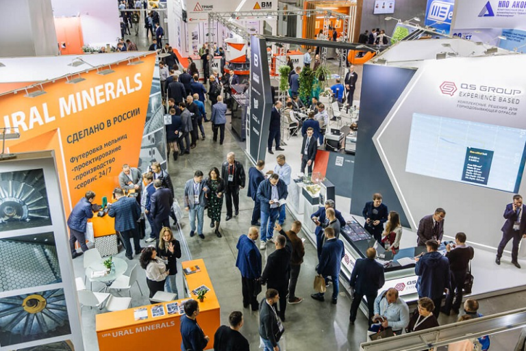
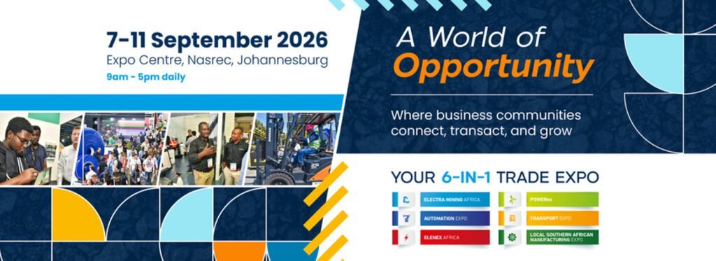
Electra Mining Africa 2026 opens on September 7 at the Johannesburg Expo Centre, Nasrec. The show runs through September 11. It is the largest mining and industrial exhibition in Southern Africa. Over 1,000 exhibitors from more than 30 countries will display their latest technologies. The event attracts 40,000+ visitors. These include mining executives, geophysicists, procurement teams, and government officials.
For geophysical exploration companies, this event matters. Africa holds 30% of the world’s mineral reserves. Yet much of the continent remains underexplored. Modern mining geophysics is changing this. Tools like electrical resistivity tomography, induced polarization, and seismic nodal systems now map ore bodies faster and cheaper than traditional drilling grids.
Geotech Instrument Co., Ltd. follows these trends closely. Our product range covers electrical, magnetic, seismic, and radar exploration systems. This article previews the geophysics technologies that will dominate discussions at Electra Mining Africa 2026.
Ⅱ. The State of African Mining Exploration in 2026
- Critical Minerals Drive Demand
Global demand for copper, lithium, cobalt, and rare earths is surging. Africa sits at the center of this supply chain. The Democratic Republic of Congo produces 70% of global cobalt. Zambia’s copper belt is expanding. South Africa’s Bushveld Complex holds platinum group metals. New discoveries in Tanzania, Botswana, and Mali attract junior explorers.
This rush creates pressure. Mining companies must find ore bodies faster. They must also reduce environmental impact. Geophysical methods offer both benefits. A single electrical resistivity tomography survey can cover square kilometers. It costs a fraction of a drill program.
- Technology Adoption Accelerates
By 2026, over 60% of new mining projects integrate geophysical methods for subsurface imaging. AI-driven targeting now combines satellite data, geochemistry, and geophysics into unified models. Drone-based geophysics bridges the gap between airborne surveys and ground operations. It delivers better resolution at lower cost.
The Mining Indaba 2026 conference in Cape Town highlighted these trends. Sessions covered “Drilling into the Future” and AI-powered exploration targeting. Zambia’s ZIMEC 2026 conference focused on de-risking exploration through technology. Electra Mining Africa 2026 continues this conversation on the exhibition floor.
Ⅲ. Key Geophysical Technologies at Electra Mining Africa 2026
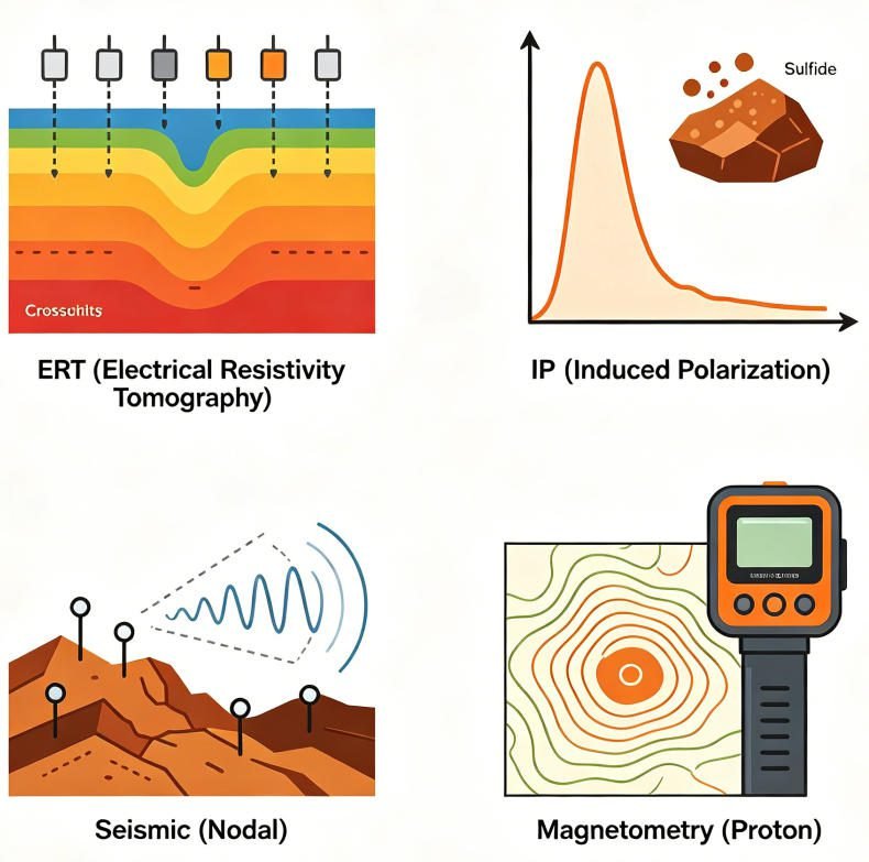
1.Electrical Resistivity Tomography (ERT)
ERT maps subsurface resistivity variations. It injects electrical current into the ground through electrode arrays. It measures voltage differences to build 2D or 3D images. Low-resistivity zones often indicate water, clay, or mineralized fractures. High-resistivity zones may indicate fresh rock or voids.
For mining exploration, ERT serves multiple purposes:
- Mapping weathered layer thickness above bedrock
- Detecting fracture zones that may host mineralization
- Delineating sulfide bodies through conductivity contrasts
- Monitoring groundwater for environmental compliance
Modern ERT systems use multi-channel acquisition. They deploy 60+ electrodes in a single array. Data processing takes hours, not days. Software like Res2DInv and EarthImager create publishable cross-sections.
At Electra Mining Africa 2026, expect to see ERT systems integrated with GPS and GIS platforms. Real-time data visualization is becoming standard. This lets field teams adjust survey parameters on the fly.
2.Induced Polarization (IP)
IP measures the delayed voltage response after current shutoff. This “chargeability” indicates disseminated sulfides, clays, or graphite. IP is essential for finding porphyry copper, VMS deposits, and gold systems.
The method works where magnetics fail. In weathered terrains, magnetic signals scatter. IP penetrates this cover. It detects chargeable minerals at depth. The Kalahari Copper Belt in Botswana and the Filabusi Greenstone Belt in Zimbabwe both rely on IP for early-stage targeting.
2026 brings advances in spectral IP. Full-spectrum chargeability analysis distinguishes ore types. Frequency-domain IP offers faster acquisition. High-density 3D grids improve resolution. Costs for 3D IP surveys range from $20,000 to $35,000 per square kilometer. This investment often saves ten times that amount in avoided dry holes.
3.Seismic Nodal Systems
Seismic exploration traditionally required heavy cables and large crews. Nodal systems change this. Each node is a self-contained recorder. It stores data internally. It requires no cables between stations.
This architecture transforms logistics. Crews deploy nodes by hand or drone. They retrieve them days later. Download is wireless and automatic. Battery life extends to 30+ days. Some systems operate continuously for months.
For deep mineral exploration, seismic nodal systems reach 500+ meters. They map bedrock topography beneath thick cover. They identify fault structures that control ore deposition. Low-power designs suit remote African mines where generator fuel is expensive.
PDAC 2026 featured over 60 sessions on seismic nodal advances. Topics included deep mineral exploration and low-power systems for off-grid operations. Expect similar focus at Electra Mining Africa 2026.
4.Proton Magnetometers
Proton precession magnetometers measure Earth’s magnetic field with ±0.5 nT accuracy. They detect magnetic minerals like magnetite and pyrrhotite. These minerals often associate with nickel, chromite, and iron ore deposits.
Modern proton magnetometers are lightweight and GPS-integrated. Some weigh under 2 kg. They log position and magnetic data simultaneously. Post-processing creates contour maps of magnetic anomalies. Gradient surveys using two sensors improve resolution.
In Africa, proton magnetometers map the Bushveld Complex’s layered intrusions. They trace chromitite seams. They identify kimberlite pipes in diamond exploration. They also serve engineering applications like locating buried steel infrastructure.
5.Ground Penetrating Radar (GPR)
GPR uses high-frequency electromagnetic pulses. It images shallow subsurface structures with centimeter-scale resolution. Depth penetration ranges from 1 to 30 meters depending on ground conductivity.
For mining, GPR maps:
- Near-surface fracture networks
- Tailings dam internal structure
- Roadbed and foundation integrity
- Underground voids and cavities
GPR complements deeper methods. A GPR survey might precede ERT or IP. It resolves shallow detail that deeper methods miss. It also guides drill collar placement to avoid near-surface hazards.
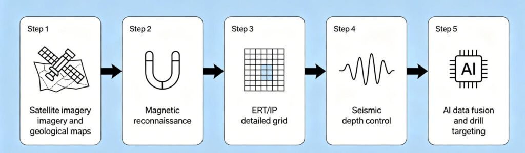
Ⅳ. Integration Trends: Multi-Parameter Surveys
1.Why Single Methods Fall Short
No single geophysical method solves every problem. ERT finds conductive zones but cannot distinguish ore from clay. IP detects sulfides but misses oxide gold. Magnetics map iron minerals but fail in weathered cover. GPR resolves shallow detail but lacks depth.
This ambiguity drives false positives. It wastes drill meters. It frustrates exploration budgets.
2.The Multi-Parameter Solution
Combining methods reduces uncertainty. A typical integrated survey might include:
- Magnetics for regional structure mapping
- ERT for conductive body delineation
- IP for sulfide identification
- Seismic for depth-to-bedrock control
Data fusion platforms merge these datasets. AI algorithms identify anomalies that satisfy multiple physical criteria. The result is sharper targeting. Drilling success rates improve from 1 in 20 to 1 in 5 in favorable cases.
At PDAC 2026, 72% of surveyed miners prioritized IP-ERT integration. This trend will dominate technical discussions at Electra Mining Africa 2026. Equipment manufacturers now bundle multi-method systems in single chassis. Field crews carry one instrument that performs resistivity, IP, and spontaneous potential surveys.
Ⅴ. Solutions for African Mining Exploration
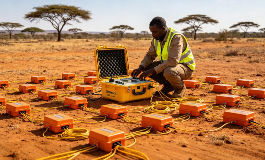
1.GIM Series: ERT and IP Integration
The Geotech GIM Series combines resistivity and IP measurement in one platform. It supports 1D, 2D, and 3D acquisitions. Key specifications include:
- 24-bit A/D conversion for microvolt resolution
- 10-channel synchronous acquisition
- Bi-directional cascading for 1,500-meter depth
- IP67 waterproof rating
- Operating range: -20°C to +60°C
The GIM Series handles African field conditions. Dust seals protect connectors. Wide temperature tolerance suits desert and highland environments. The rolling measurement mode covers long profiles without rewiring. Data exports to Res2DInv, EarthImager, and other standard software.
For mining clients, the GIM Series offers specific advantages. High-density IP arrays detect disseminated sulfides at low concentrations. Multi-channel acquisition reduces survey time by 60% compared to single-channel systems. This efficiency matters when daily field costs exceed $5,000.
2.Proton Magnetometer Series
Geotech’s proton precession magnetometers deliver ±0.5 nT accuracy. They feature GPS integration and automatic data logging. Internal storage holds 100,000+ readings. USB and Bluetooth export simplify data transfer.
These instruments suit African exploration programs. They operate for 16 hours on rechargeable batteries. Solar charging kits extend deployment in remote areas. The compact design fits in standard airline luggage. This reduces freight costs for international projects.
3.Seismic Nodal and GPR Systems
Geotech’s seismic nodal systems offer cable-free acquisition. Each node records independently. Deployment requires no heavy vehicles. A crew of two can lay 100 nodes per day. Data download is wireless via tablet interface.
Our GPR systems provide high-resolution shallow imaging. They use shielded antennas to minimize air-wave interference. Real-time display shows subsurface features as the operator walks. Digital filtering removes noise from power lines and radio towers.
4.Software and Support
Geotech provides more than hardware. We offer:
- Training programs for field crews and data processors
- Technical support via email, phone, and video call
- Custom survey design for specific geological targets
- Data processing services for clients without in-house expertise
This support ecosystem matters in Africa. Local universities produce geoscience graduates. But practical training in modern instrumentation is scarce. Geotech fills this gap. We partner with African mining departments and exploration companies. We build local capacity.
Ⅵ. Sustainability and ESG Compliance
1.Low-Impact Exploration
Environmental, social, and governance (ESG) standards now govern mining investment. By 2026, ESG compliance is mandatory for project financing. Geophysical methods support these goals.
Electrical and magnetic surveys require no excavation. They disturb no vegetation. They generate no tailings. A single ERT line replaces dozens of test pits. This reduces land disturbance by 90% compared to grid drilling.
2.Carbon Footprint Reduction
Seismic nodal systems cut fuel consumption. Cable-free deployment needs no heavy vehicles. Solar charging eliminates generator runtime. Some nodal systems operate for months on internal batteries.
Data integration also helps. AI targeting reduces the number of drill holes needed. Fewer holes mean less fuel, less water, and less waste. This aligns with Scope 3 emissions reduction targets.
3.Community Relations
Geophysical surveys are quiet. They create no dust. They operate without blasting. This minimizes community disruption. In sensitive areas, this can mean the difference between project approval and rejection.
Electra Mining Africa 2026 features a dedicated Sustainability & Energy Day on Wednesday, September 9. Expect geophysical service providers to highlight these ESG benefits in their presentations.
Ⅶ. What to Expect at Electra Mining Africa 2026
1.Exhibition Zones
The 2026 show introduces a new Orange Zone for outdoor equipment displays. This complements the existing Red, Blue, Green, and Yellow Zones. The Orange Zone focuses on OEM machinery dealers and aftermarket suppliers.
For geophysics exhibitors, indoor halls remain the primary venue. Topographic and geophysical equipment is listed as a featured product category. Expect dedicated displays for ERT, IP, magnetics, and seismic systems.
2.Theme Days
Tuesday, September 8: Automation & Digital Day Wednesday, September 9: Sustainability & Energy Day Thursday, September 10: Women in Mining & Engineering Day Friday, September 11: South Africa Day
Geophysical technologies align with Tuesday and Wednesday themes. Digital acquisition, AI interpretation, and low-carbon survey methods fit both automation and sustainability narratives.
3.Seminar Program
The Seminar Theatre hosts over 40 speakers. Topics include innovation, safety, local manufacturing, and technology. SAIMechE partners on technical content. SAIMM hosts mining-specific sessions.
For exploration professionals, key sessions will cover:
- AI in mineral targeting
- Remote sensing for greenfield exploration
- Geophysical case studies from African projects
- Integration of drone and ground-based surveys
Ⅷ. Planning Your Visit
1.Registration
Visitor passes are free for standard entry. Register at www.electramining.co.za. Upgraded packages cost R600 per day or R2,000 for the full week. Premium access includes lounge facilities and networking events.
2.Travel Logistics
Johannesburg Expo Centre, Nasrec is accessible by car and public transport. OR Tambo International Airport is 45 minutes away. Hotels near the venue fill quickly. Book accommodation early.
Ⅸ. Conclusion
Electra Mining Africa 2026 arrives at a pivotal moment. African mining is expanding. Critical mineral demand is surging. Exploration technology is advancing. Mining geophysics sits at the intersection of these trends.
Electrical resistivity tomography, induced polarization, and seismic nodal systems now deliver results that were impossible a decade ago. Multi-parameter integration and AI interpretation further sharpen targeting. ESG compliance makes geophysical methods more attractive than ever.
For exploration teams operating in Africa, Electra Mining Africa 2026 is the place to evaluate these technologies. Compare instruments. Attend seminars. Meet suppliers. Build partnerships that will shape the next decade of African mineral discovery.
FAQ
Q1: When and where is Electra Mining Africa 2026 taking place?
A: Electra Mining Africa 2026 runs from September 7 to 11, 2026, at the Johannesburg Expo Centre, Nasrec, in South Africa. It is the largest mining and industrial trade show in Southern Africa, featuring 1,000+ exhibitors and 40,000+ visitors.
Q2: What geophysical technologies will be featured at Electra Mining Africa 2026?
A: The show will showcase electrical resistivity tomography (ERT), induced polarization (IP), seismic nodal systems, proton magnetometers, and ground penetrating radar (GPR). Multi-parameter integration and AI-driven data interpretation will be key themes.
Q3: How does electrical resistivity tomography help in mining exploration?
A: ERT maps subsurface resistivity variations to identify conductive zones that may indicate mineralized fractures, sulfide bodies, or groundwater. It covers large areas quickly and costs far less than grid drilling programs.
Q4: Why is induced polarization important for African mineral exploration?
A: IP detects disseminated sulfides in weathered terrains where magnetic methods fail. It is essential for finding porphyry copper, VMS deposits, and gold systems beneath thick cover in regions like the Kalahari Copper Belt.
Q5: How do seismic nodal systems improve exploration efficiency?
A: Seismic nodal systems eliminate cables. Each node records independently. Crews deploy them by hand or drone. This reduces logistics costs, speeds up acquisition, and enables deep mapping to 500+ meters in remote African locations.