Welcome to Geotech!

GeoExplora 2026: Andean Geophysics Tech Preview
TIPS:GeoExplora 2026 convenes October 5–7 in Cusco’s Sacred Valley. Over 50 new mining exploration projects worth $287.5 million will shape Peru’s geological future. This report examines how resistivity imaging and induced polarization technologies are de-risking Andean mineral exploration. Discover why resistivity imaging now dominates deep-cover targeting in the Andean copper belt. Learn how induced polarization distinguishes ore from clay in Peru’s most challenging terrains.
Ⅰ. Introduction
GeoExplora 2026 opens on October 5 at the Vida Wasi Convention Center in Urubamba, Cusco. The congress runs through October 7. It is Peru’s premier geological exploration event. The Capítulo de Ingeniería Geológica of CIP Lima organizes it. President Roque Benavides Ganoza leads the organizing committee.
This year’s event arrives at a critical moment. Peru holds 45.5% of the nation’s mining project portfolio in its southern regions. Cusco alone manages over $2 billion in construction and sustaining investment. Thirty-two new exploration projects worth $287.5 million are under review. The stakes are high. The tools must match.
Geophysical exploration technologies are central to this narrative. Resistivity imaging, induced polarization, and seismic nodal systems now map ore bodies beneath thick Andean cover. They reduce dry holes. They cut costs. They align with ESG mandates.
Geotech Instrument Co., Ltd. designs instruments for these exact challenges. This article previews the geophysics technologies that will dominate GeoExplora 2026 discussions.
Ⅱ. The Andean Exploration Landscape in 2026
1.Critical Minerals and Copper Dominance
Peru is the world’s third-largest copper producer. The Andean copper belt stretches from Chile through southern Peru. It hosts world-class porphyry deposits. Cerro Verde, Cuajone, and Antapaccay define this belt.
Global demand for copper is accelerating. Electric vehicles, renewable energy, and grid expansion drive this surge. Peru’s mining sector projects $7.6 billion in planned investments for 2026. Eight major projects are advancing. Brownfield expansions like Cerro Verde Optimization dominate. Greenfield discoveries like Sombrero ($106.2M investment) and Trapiche ($36.8M) are gaining traction.
Exploration investment grew over 40% in 2025. Companies are preparing for the next commodity cycle. They need better subsurface intelligence. Geophysical methods provide it.
2.The Deep-Cover Challenge
Much of the Andean copper belt hides beneath post-mineral cover. Sedimentary and pyroclastic deposits blanket roughly 60% of the metallogenic belt. This cover eroded from the Western Andean Mountain Front. It conceals potential deposits at depth.
Traditional surface mapping fails here. Geochemistry alone cannot penetrate. Geophysics is the only tool that sees through cover. Resistivity imaging maps conductive alteration zones. Induced polarization detects disseminated sulfides. Seismic nodal systems image bedrock topography beneath thick sequences.
The Don Javier discovery confirms this approach. It sits 300 meters below surface in the Cerro Verde district. Historical geophysical surveys guided the initial targeting. The deposit now extends the district’s resource base.

Ⅲ. Key Geophysical Technologies at GeoExplora 2026
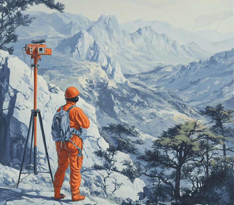
1.Resistivity Imaging (ERT)
Resistivity imaging, also called electrical resistivity tomography (ERT), measures subsurface electrical properties. It injects DC current through surface electrodes. It records voltage differences to build 2D or 3D cross-sections.
For Andean exploration, ERT serves critical functions:
- Mapping weathered layer thickness above fresh bedrock
- Detecting conductive alteration halos around porphyry systems
- Delineating groundwater systems for environmental baseline studies
- Monitoring tailings dam integrity
Modern ERT systems deploy 60+ electrodes in automated arrays. Multi-channel acquisition collects thousands of measurements per hour. Inversion software like Res2DInv and EarthImager process data in minutes. Real-time visualization lets crews adjust layouts on-site.
The Cordillera Blanca studies demonstrate ERT’s value in Peru. Researchers combined ERT with vertical electrical sounding (VES) and seismic refraction. They mapped depth to saturation and bedrock geometry in alpine valleys. Average depth to bedrock was 25 meters. Water table depths varied across the valley. These data informed groundwater flow models for glacier-fed watersheds.
At GeoExplora 2026, expect ERT systems bundled with GPS and GIS platforms. Cloud-based processing is becoming standard. Field teams upload data from remote sites. Inversion runs on servers in Lima or overseas. Results return within hours.
2.Induced Polarization (IP)
IP measures the delayed voltage response after current shutoff. This chargeability indicates disseminated sulfides, clay, or graphite. In mining exploration, IP is the primary tool for finding porphyry copper and VMS deposits.
The Andean context makes IP essential. Weathered terrain scatters magnetic signals. Thick cover obscures surface indicators. IP penetrates these challenges. It detects chargeable minerals at depth.
Spectral IP advances are reshaping the field. Full-spectrum chargeability analysis distinguishes ore types. Frequency-domain IP offers faster acquisition than traditional time-domain methods. High-density 3D grids improve resolution for complex targets.
In Peru’s Southern Copper Belt, IP surveys target concealed extensions of known deposits. The Caspiche and Luchitay projects rely on IP for early-stage targeting. These greenfield prospects sit in the same metallogenic belt as Cerro Verde. IP helps explorers find the next Don Javier.
Costs for 3D IP surveys range from $20,000 to $35,000 per square kilometer. This investment often saves ten times that amount in avoided dry holes. At GeoExplora 2026, expect IP-ERT integration to dominate technical discussions.
3.Seismic Nodal Systems
Seismic exploration has evolved. Traditional systems required heavy cables and large crews. Nodal systems eliminate cables entirely. Each node is a self-contained digital recorder. It stores data internally. It requires no interconnection.
This architecture transforms Andean logistics. Crews deploy nodes by hand on steep terrain. They retrieve them days later. Download is wireless. Battery life extends to 30+ days. Some systems operate continuously for months.
For deep mineral exploration, nodal seismic reaches 500+ meters. It maps bedrock topography beneath thick cover. It identifies fault structures that control ore deposition. In the Andes, this means seeing through hundreds of meters of volcanic and sedimentary cover.
Low-power designs suit remote Peruvian sites. Generator fuel is expensive in the highlands. Solar charging extends deployment. Some nodal systems consume less than 1 watt per station.
The Quechua project in Espinar illustrates this need. JX Nippon’s copper prospect sits at high altitude. Infrastructure is minimal. Cable-free seismic would reduce logistics costs significantly. The project targets 100,000 tonnes of copper per year. Better subsurface imaging improves resource confidence.
4.Proton Magnetometers
Proton precession magnetometers measure Earth’s magnetic field with high precision. They detect magnetic minerals like magnetite and pyrrhotite. These minerals often associate with copper, nickel, and iron ore systems.
Modern proton magnetometers are lightweight and GPS-integrated. Some weigh under 2 kg. They log position and magnetic data simultaneously. Post-processing creates contour maps of magnetic anomalies.
In Peru, magnetometers map the structural framework of porphyry systems. They identify magnetic destruction zones above ore bodies. They trace dike swarms that feed mineralization. They also serve engineering applications like locating buried infrastructure near mine sites.
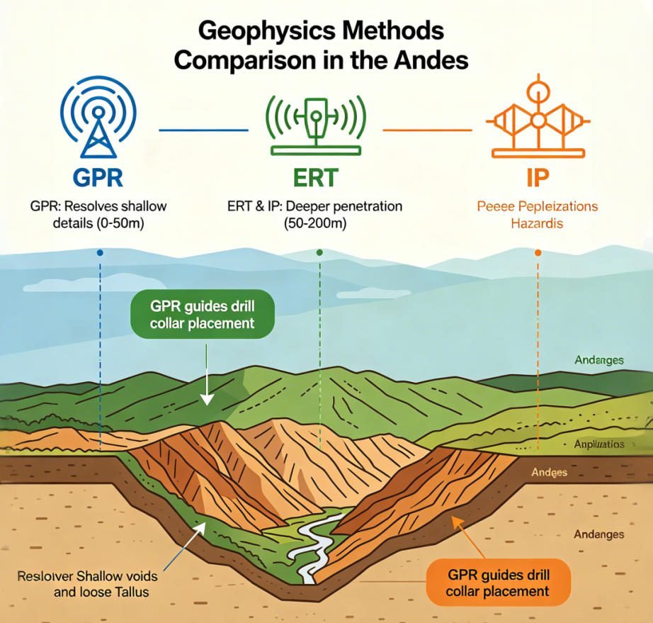
5.Ground Penetrating Radar (GPR)
GPR uses high-frequency electromagnetic pulses. It images shallow structures with centimeter-scale resolution. Depth penetration ranges from 1 to 30 meters.
For Andean mining, GPR maps:
- Near-surface fracture networks in bedrock
- Roadbed and foundation integrity at high-altitude camps
- Tailings dam internal structure
- Glacial till thickness above bedrock
GPR complements deeper methods. It resolves shallow detail that ERT and IP miss. It also guides drill collar placement to avoid near-surface hazards like voids or loose talus.
Ⅳ. Integration Trends: Multi-Parameter Surveys
1.Why Single Methods Fall Short
No single geophysical method solves every Andean problem. ERT finds conductive zones but cannot distinguish ore clay from alteration clay. IP detects sulfides but misses oxide gold. Magnetics maps iron minerals but fails in weathered cover. GPR resolves shallow detail but lacks depth.
This ambiguity drives false positives. It wastes drill meters. It frustrates exploration budgets in a high-cost environment.
2.The Multi-Parameter Solution
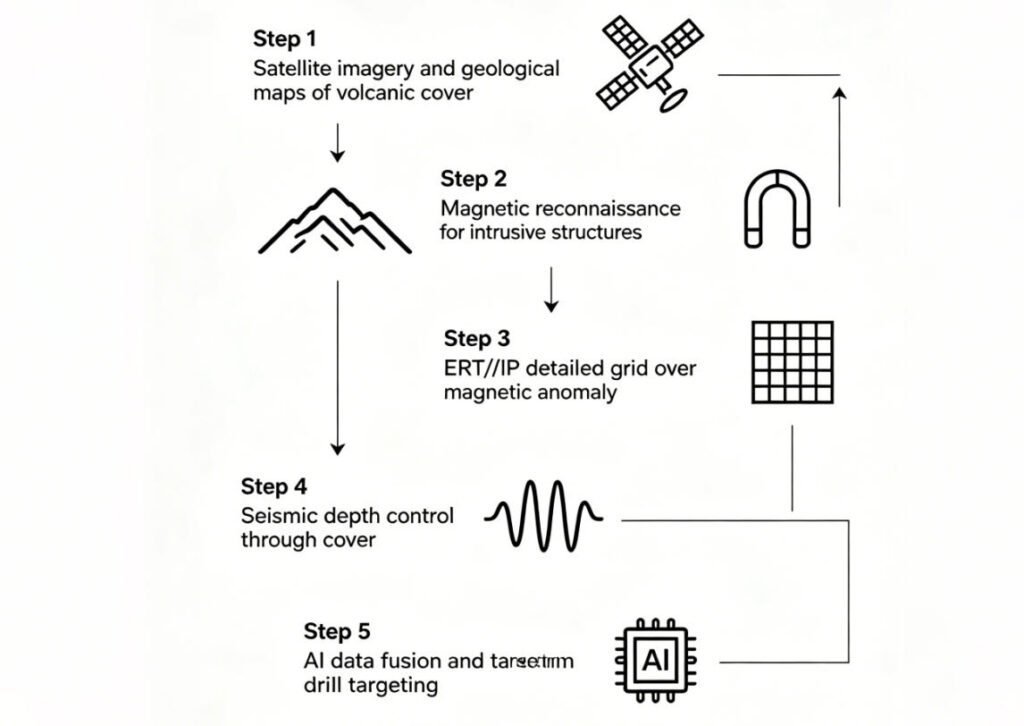
Combining methods reduces uncertainty. A typical integrated Andean survey might include:
- Magnetics for regional structure and intrusive body mapping
- ERT for conductive alteration halo delineation
- IP for sulfide identification within halos
- Seismic for depth-to-bedrock and structural control
Data fusion platforms merge these datasets. AI algorithms identify anomalies that satisfy multiple physical criteria. The result is sharper targeting. Drilling success rates improve significantly.
At PDAC 2026, 72% of surveyed miners prioritized IP-ERT integration. This trend will be central at GeoExplora 2026. Equipment manufacturers now bundle multi-method systems in single chassis. The Geotech GIM Series, for example, performs resistivity, IP, and spontaneous potential surveys in one deployment.
Ⅴ. Solutions for Andean Exploration
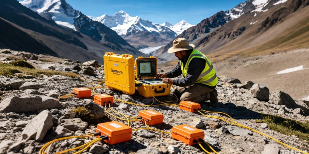
1.GIM Series: Resistivity and IP Integration
The Geotech GIM Series combines resistivity imaging and induced polarization in one platform. It supports 1D, 2D, and 3D acquisitions. Key specifications include:
- 24-bit A/D conversion for microvolt resolution
- 10-channel synchronous acquisition
- Bi-directional cascading for 1,500-meter depth penetration
- IP67 waterproof rating
- Operating range: -20°C to +60°C
The GIM Series handles Andean field conditions. Dust seals protect connectors at high altitude. Wide temperature tolerance suits desert coast and alpine environments. The rolling measurement mode covers long profiles without rewiring. Data exports to Res2DInv, EarthImager, and other standard software.
For Andean mining clients, the GIM Series offers specific advantages. High-density IP arrays detect disseminated sulfides at low concentrations. Multi-channel acquisition reduces survey time by 60% compared to single-channel systems. This efficiency matters when daily field costs in remote Peru exceed $5,000.
2.Proton Magnetometer Series
Geotech’s proton precession magnetometers deliver ±0.5 nT accuracy. They feature GPS integration and automatic data logging. Internal storage holds 100,000+ readings. USB and Bluetooth export simplify data transfer.
These instruments suit Andean exploration programs. They operate for 16 hours on rechargeable batteries. Solar charging kits extend deployment at remote sites. The compact design fits in standard airline luggage. This reduces freight costs for international projects flying into Lima or Cusco.
3.Seismic Nodal and GPR Systems
Geotech’s seismic nodal systems offer cable-free acquisition. Each node records independently. Deployment requires no heavy vehicles. A crew of two can lay 100 nodes per day on steep terrain. Data download is wireless via tablet interface.
Our GPR systems provide high-resolution shallow imaging. They use shielded antennas to minimize air-wave interference. Real-time display shows subsurface features as the operator walks. Digital filtering removes noise from power lines and radio towers.
4.Software and Support
Geotech provides more than hardware. We offer:
- Training programs for Peruvian field crews and data processors
- Technical support via email, phone, and video call in Spanish and English
- Custom survey design for specific Andean geological targets
- Data processing services for clients without in-house expertise
This support ecosystem matters in Peru. Local universities produce geoscience graduates. But practical training in modern instrumentation is scarce. Geotech fills this gap. We partner with Peruvian mining departments and exploration companies. We build local capacity.
Ⅵ. Sustainability and ESG Compliance
1.Low-Impact Exploration
Environmental, social, and governance (ESG) standards now govern mining investment. Peru’s Ministry of Energy and Mines (MINEM) emphasizes responsible exploration. GeoExplora 2026 dedicates an entire thematic axis to environmental management and social responsibility.
Geophysical methods support these goals. Electrical and magnetic surveys require no excavation. They disturb no vegetation. They generate no tailings. A single ERT line replaces dozens of test pits. This reduces land disturbance by 90% compared to grid drilling.
The Vida Wasi venue itself reflects this commitment. The center supports child health and vulnerable communities. Hosting GeoExplora 2026 there reinforces the mining sector’s social license.
2.Carbon Footprint Reduction
Seismic nodal systems cut fuel consumption. Cable-free deployment needs no heavy vehicles. Solar charging eliminates generator runtime. Some nodal systems operate for months on internal batteries.
Data integration also helps. AI targeting reduces the number of drill holes needed. Fewer holes mean less fuel, less water, and less waste. This aligns with Scope 3 emissions reduction targets that major miners now report.
3.Community Relations
Geophysical surveys are quiet. They create no dust. They operate without blasting. This minimizes community disruption. In Peru’s socially sensitive mining regions, this can mean the difference between project approval and conflict.
GeoExplora 2026’s thematic axis on “Geology and Energy of the Future” will address these intersections. Expect geophysical service providers to highlight ESG benefits in their presentations.
Ⅶ. What to Expect at GeoExplora 2026
1.Thematic Axes
GeoExplora 2026 features seven thematic axes:
- Technology and Innovation
- Digital Transformation
- Geological Mining Exploration
- Oil and Gas Exploration
- Environmental Management and Social Responsibility
- Geology and Energy of the Future
- Geology Applied to National Development
Geophysical technologies align with the first three axes. Digital acquisition, AI interpretation, and low-carbon survey methods fit both innovation and sustainability narratives.
2.GeoExplora 5.0 Expo
For the first time, GeoExplora 2026 includes a trade expo. GeoExplora 5.0 will showcase advanced exploration technology. Exhibitors will display:
- Subsurface exploration machinery and equipment
- Digital modeling and data management systems
- Geophysical and geotechnical instruments
- Drilling technology and automation
- Environmental monitoring and energy efficiency solutions
This expo creates a direct platform for instrument manufacturers. Geotech will demonstrate the GIM Series, proton magnetometers, and seismic nodal systems live.
3.High-Level Organizing Committee
The organizing committee includes Peru’s most influential mining figures:
- Roque Benavides Ganoza, President (GeoExplora 2026)
- Manolo Zúñiga, President and CEO of PetroTal
- Luis Rivera, Glencore South America Operations Director
- Rómulo Mucho, former Minister of Energy and Mines
- Jorge Meza Viveros, Southern Peru Copper Operations Director
- Claudio Cáceres, Las Bambas Sustainability VP
This caliber ensures GeoExplora 2026 attracts decision-makers. Technical presentations reach audiences with procurement authority.
Ⅷ. Planning Your Visit
1.Registration
Contact the organizers at geologia@ciplima.org.pe or call +51 989 896 125. The venue is Vida Wasi Convention Center, Urubamba, Cusco. Accommodation in the Sacred Valley books quickly. Reserve early.
2.Travel Logistics
Alejandro Velasco Astete International Airport (CUZ) serves Cusco. It is a 90-minute drive to Urubamba. Lima connects to Cusco with multiple daily flights. Altitude acclimatization is essential. The venue sits at 2,800 meters above sea level.
Ⅸ. Conclusion
GeoExplora 2026 arrives at a pivotal moment for Andean exploration. Peru’s mining sector is expanding. Critical mineral demand is surging. Exploration technology is advancing. Resistivity imaging and induced polarization sit at the intersection of these trends.
These methods now deliver results that were impossible a decade ago. They see through post-mineral cover. They distinguish ore from false anomalies. They reduce environmental impact. Multi-parameter integration and AI interpretation further sharpen targeting.
For exploration teams operating in Peru, GeoExplora 2026 is the place to evaluate these technologies. Compare instruments. Attend seminars. Meet suppliers. Build partnerships that will shape the next decade of Andean mineral discovery.
FAQ
Q1: When and where is GeoExplora 2026 taking place?
A: GeoExplora 2026 runs from October 5 to 7, 2026, at the Vida Wasi Convention Center in Urubamba, Cusco, Peru. It is organized by the Capítulo de Ingeniería Geológica of CIP Lima.
Q2: What geophysical technologies will be featured at GeoExplora 2026?
A: The congress will showcase resistivity imaging (ERT), induced polarization (IP), seismic nodal systems, proton magnetometers, and ground penetrating radar (GPR). Multi-parameter integration and AI-driven data interpretation will be central themes.
Q3: How does resistivity imaging help in Andean mineral exploration?
A: Resistivity imaging maps conductive alteration zones and weathered layers above bedrock. It penetrates post-mineral cover that obscures surface indicators. In Peru’s Andean copper belt, ERT guides targeting for concealed porphyry deposits.
Q4: Why is induced polarization critical for Peruvian copper exploration?
A: IP detects disseminated sulfides in weathered terrains where magnetic methods fail. It distinguishes ore-related chargeability from clay false anomalies. This is essential for finding porphyry copper beneath thick cover in the Andes.
Q5: How do seismic nodal systems improve exploration in the Andes?
A: Seismic nodal systems eliminate cables. Each node records independently. Crews deploy them by hand on steep terrain. This reduces logistics costs and enables deep mapping to 500+ meters through thick volcanic and sedimentary cover.