Welcome to Geotech!
-1.png)


The Future of Geomagnetic Survey Equipment: Next-Generation Magnetometers
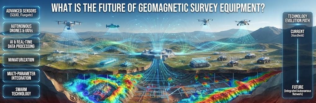
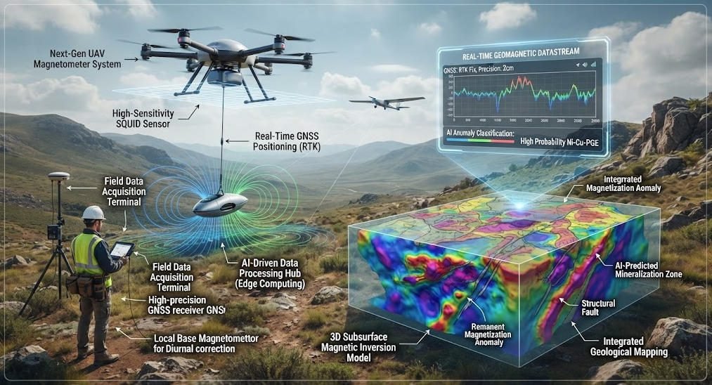
Overview:The future of geomagnetic survey equipment is moving beyond higher sensor sensitivity toward integrated systems that combine geomagnetic survey technology with autonomous platforms, AI-assisted processing, precise positioning, and multi-sensor fusion. The future of geomagnetic survey equipment will depend not only on better magnetometers, but also on cleaner acquisition, stronger quality control, faster interpretation, and application-specific system integration.
Ⅰ. Introduction to Geomagnetic Survey Equipment Evolution
1. Role and Historical Context
Geomagnetic survey equipment measures spatial variations in the Earth’s magnetic field to infer subsurface geology and mineral distribution. For decades, these tools have supported mineral exploration, geological mapping and archaeological investigation worldwide. Traditional systems relied on proton precession magnetometers with limited sampling rates and stationary operation. Modern advances in sensor physics, digital electronics and autonomous platforms are reshaping the entire field.
2. Industry Drivers for Technological Change
Three key forces drive innovation in geomagnetic survey technology. First, critical mineral demand pushes exploration into deeper cover and more remote terrain. Second, digital transformation across geosciences demands faster data delivery and automated interpretation. Third, emerging applications from climate monitoring to space exploration require new form factors and performance levels.
These drivers shift industry expectations from basic point measurement to full-spectrum intelligent systems. Equipment must deliver higher sensitivity, faster acquisition and greater operational flexibility than legacy designs. This transition creates both technical challenges and market opportunities for manufacturers and service providers.
Ⅱ. Core Sensor Technology Breakthroughs
1. Quantum Magnetometer Revolution
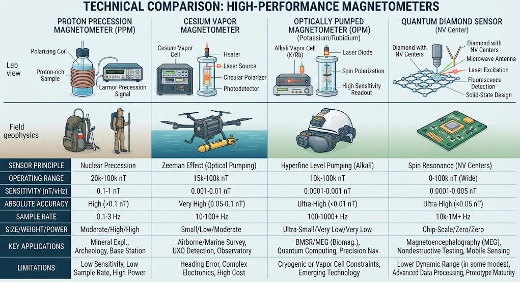
Quantum sensing represents the most transformative advance in magnetic measurement technology. Two primary technologies are transitioning from laboratory to field deployment: optically pumped magnetometers (OPMs) and superconducting quantum interference devices (SQUIDs).
| Technology | Sensitivity | Bandwidth | Weight | Primary Field Application |
|---|---|---|---|---|
| Proton Precession Magnetometer | 0.05 – 1 nT | < 10 Hz | 5 – 15 kg | Conventional ground survey |
| Optically Pumped Magnetometer (OPM) | 10 – 100 pT/√Hz | 50 – 100 Hz | ~1 kg | High-resolution mobile survey |
| SQUID Magnetometer | < 1 fT/√Hz | DC – kHz | 2 – 5 kg (with cryogen) | Deep mineral, hydrocarbon exploration |
OPMs exploit atomic spin polarization to achieve high sensitivity at significantly higher bandwidth than proton systems. Recent manufacturing advances have packaged OPMs into compact, lightweight units weighing approximately 1 kilogram. Field trials across the Highland Boundary Fault in Scotland demonstrated 90 Hz continuous sampling with OPM systems. This compares to approximately one measurement every 200 meters with stationary proton instruments. The higher sampling rate reduces spatial aliasing and identifies smaller geological structures below 200 meters in scale.
SQUID magnetometers reach sensitivity levels approaching the fundamental quantum limit. They detect magnetic flux changes orders of magnitude smaller than conventional technologies. While historically limited by cryogenic cooling requirements, newer cryogen-free designs are expanding field applicability. Depending on geological conditions and target depth, SQUID systems can detect deep magnetic signatures invisible to standard instruments.
2. Performance and Cost Implications
Quantum sensors deliver measurable productivity gains for exploration programs. Industry data from major mining companies indicate 35–45% reduction in greenfield exploration cycle times. Superior sensitivity enables detection of subtle anomalies associated with deep ore bodies and finer lithological contrasts. This reduces unnecessary drilling programs and improves overall exploration success rates.
The geophysical survey segment holds approximately 28.3% of the fieldable quantum magnetometer market as of 2025. Market analysis projects 9.7% compound annual growth through 2034. This growth is driven by demand for critical minerals including lithium, cobalt and rare earth elements. As production costs decline, quantum technology will penetrate mid-tier and entry-level equipment markets.
Ⅲ. Miniaturization and Portable Deployment Innovations
1. Compact Sensor Design Trends
Miniaturization is redefining where and how geomagnetic surveys can be conducted. Smaller, lower-power sensors enable deployment in previously inaccessible locations and platforms. Probe volumes for advanced quantum magnetometers have shrunk to as little as 7 cubic centimeters. This miniaturization comes without proportional loss of sensitivity or measurement stability.
2. Drone and UAV-Based Survey Platforms
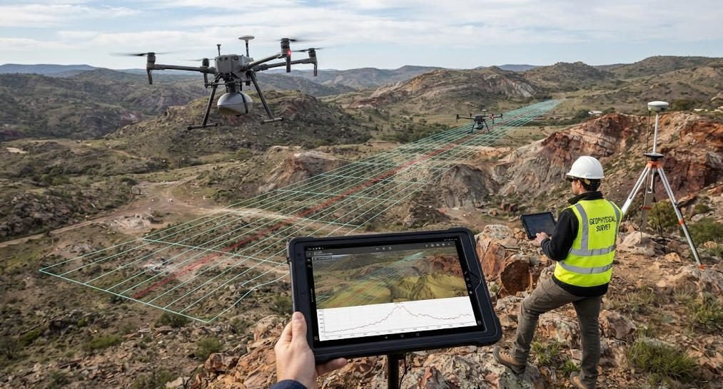
Unmanned aerial vehicles equipped with miniaturized magnetometers represent the fastest-growing survey method. Drone-based systems combine rapid coverage with high-resolution data acquisition. They eliminate the logistical burden of ground surveys across difficult terrain.
| Survey Method | Coverage Rate | Line Spacing | Typical Altitude | Primary Application |
|---|---|---|---|---|
| Ground Walking Survey | 5 – 15 km/day | 10 – 50 m | Ground level | Detailed prospecting, UXO detection |
| Drone Magnetic Survey | 50 – 200 km/day | 25 – 100 m | 20 – 50 m AGL | Regional reconnaissance, structure mapping |
| Fixed-Wing Airborne | 500 – 2000 km/day | 200 – 500 m | 100 – 300 m AGL | Large-scale regional mapping |
Drone surveys typically operate at 20–50 meters above ground level with line spacing of 25–50 meters. This configuration produces higher-resolution data than traditional airborne surveys at lower cost. At the Sidhan Mn-Fe ore project in India, custom octacopter drone magnetic surveys successfully identified ore-related magnetic highs. Results correlated well with subsequent borehole BH-8A drilling data.
In Canada’s Barker Bay gold project, drone magnetic and LiDAR surveys defined northwest-trending magnetic features. These features coincided with a >700-meter gold-in-soil anomaly identified by surface sampling. The combined dataset refined trenching locations and prioritized targets for follow-up drill testing.
For rare earth element exploration in carbonatite deposits, drone magnetometry detects magnetite-rich phases associated with mineralization. Case examples from Québec and Santa Anna complexes demonstrate 25–50 meter line spacing produces detailed models guiding drilling. This approach significantly reduces exploration costs compared to ground survey methods.
3. Extreme Environment and Space Deployment
Miniaturized sensors enable operation in extreme environments inaccessible to conventional equipment. Deep-sea diamond quantum vector magnetometers have been successfully tested on manned submersibles. These devices provide precise vector measurement and tolerate high pressure and corrosive marine conditions.
In space exploration, miniaturized magnetometers are standard payloads on planetary rovers and orbiters. NASA and ESA missions use compact magnetic sensors to study planetary magnetic fields and subsurface structure. Swarm concepts with multiple mini-satellites promise unprecedented resolution of Earth’s magnetic field. These space-based systems support climate research, space weather forecasting and geophysical modeling.
Ⅳ. AI and Automation in Geomagnetic Survey Workflows
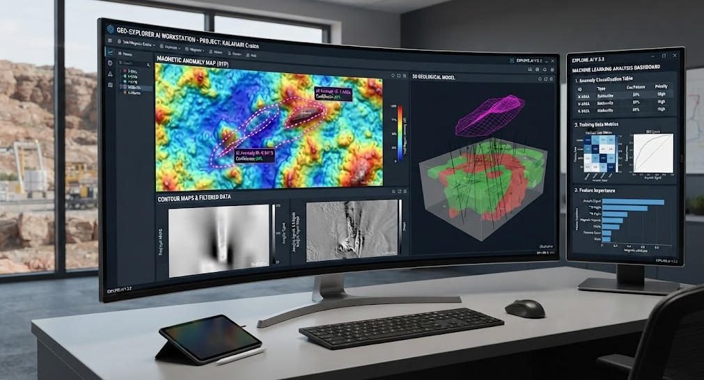
1. AI-Powered Data Processing and Interpretation
Artificial intelligence and machine learning are transforming geomagnetic data handling. These technologies automate processing, anomaly detection and geological interpretation. They reduce human error and accelerate analysis from weeks to days or hours.
Deep learning models trained on large datasets identify subtle magnetic signatures with high confidence. Algorithms distinguish between geological anomalies and cultural noise sources. This reduces false alarm rates and improves target identification accuracy. For underground tunnel and UXO detection, AI systems deliver significantly higher detection reliability than manual interpretation.
ML algorithms also enable real-time equipment calibration and adaptive noise suppression. Systems learn environmental variations and adjust processing parameters dynamically. This ensures consistent data quality even in changing survey conditions.
2. Autonomous Survey Operations
Automated survey platforms enable continuous 24/7 operation with minimal human intervention. Drones with intelligent navigation and mission planning fly pre-programmed survey grids autonomously. They maintain precise altitude and line spacing even over complex terrain.
Automated data processing pipelines generate maps and anomaly reports in near real time. Geologists focus on interpretation and decision-making rather than manual data handling. In mineral exploration, this reduces survey timelines from months to weeks. The accelerated workflow compresses the entire path from discovery to resource evaluation.
3. Cloud Integration and Collaborative Analysis
Modern geomagnetic systems feature seamless cloud connectivity. Field data transmits instantly to cloud-based platforms for processing and visualization. This “internet of geosensors” enables global teams to collaborate on data simultaneously. Distributed expert teams can review results and provide guidance without travel.
Cloud platforms also enable centralized data management and version control. Survey data, processing parameters and interpretation products reside in a single accessible system. This improves auditability and simplifies regulatory compliance reporting.
Ⅴ. Multi-Functional and Integrated System Design
1. All-in-One Device Architecture
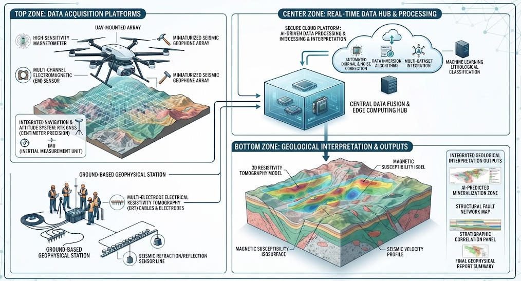
Multi-functional equipment design maximizes utility by combining multiple capabilities in single platforms. Future geomagnetic tools integrate data logging, GPS positioning, inertial measurement and real-time analysis. This eliminates the need for separate instruments and streamlines field logistics.
Handheld all-in-one devices combine magnetic measurement, geolocation and on-board processing. Field personnel can generate preliminary subsurface models directly in the field. This capability enables real-time decision-making and adaptive survey design. Teams can extend survey lines over promising anomalies or reduce coverage over barren areas.
2. Modular and Configurable Systems
Modular design allows users to customize equipment for specific project requirements. Users add sensor modules for environmental monitoring, gravity measurement or electromagnetic surveying as needed. This approach enhances versatility and improves cost-effectiveness across diverse project portfolios.
Modular architecture also simplifies upgrades and maintenance. New sensor technologies can be integrated without replacing entire systems. This extends equipment service life and protects capital investment.
3. Multi-Physics Integration
Advanced systems combine multiple geophysical measurement technologies into single platforms. Integrated magnetic, gravity and electromagnetic sensors provide comprehensive subsurface data. Multi-physics data reduces interpretation ambiguity compared to single-method surveys.
In urban planning applications, integrated portable tools simultaneously map subsurface structures and assess soil stability. This single-instrument capability reduces mobilization costs and survey time on construction sites. For mineral exploration, combined magnetic and IP surveys provide both structural and mineralogical information.
Ⅵ. Industry Applications and Real-World Impact
1. Mineral Exploration and Resource Development
Mineral exploration remains the largest commercial application for advanced geomagnetic equipment. Improved sensitivity and survey efficiency directly impact discovery rates and project economics.
Deep exploration under thick cover benefits most from quantum sensor technology. Subtle magnetic signatures from deep ore bodies that were previously undetectable now become visible. This extends exploration depth and opens new prospective areas in mature mining districts.
For critical minerals like rare earth elements, drone magnetic surveys enable rapid assessment of large prospects. High-resolution mapping identifies structural controls and carbonatite intrusions associated with mineralization. This approach is particularly valuable in remote regions with limited infrastructure.
2. Environmental Monitoring and Climate Research
Geomagnetic methods support environmental monitoring through detection of subsurface changes. Time-lapse magnetic surveys monitor plume migration, permafrost thaw and groundwater movement. Miniaturized sensors enable dense monitoring networks at reasonable cost.
In climate research, magnetic measurements detect subtle shifts associated with melting ice sheets and ocean current changes. Space-based magnetic constellations provide global coverage for these applications. The data contributes to early warning systems for environmental threats and climate modeling.
3. Engineering and Infrastructure Applications
Geomagnetic surveys support engineering projects through detection of subsurface hazards and utilities. Automated drone surveys rapidly map pipeline routes and transmission corridors. They detect buried metallic infrastructure and geological features that impact construction.
For dam and levee safety, magnetic methods detect seepage pathways and internal erosion features. Time-lapse surveys monitor changes over the asset lifecycle. This supports proactive maintenance and reduces failure risk.
4. Archaeological and Heritage Investigation
High-resolution magnetic surveys reveal buried archaeological features without excavation. Modern systems detect subtle anomalies from ancient structures, kilns and settlement boundaries. Drone surveys cover large heritage sites efficiently with minimal ground disturbance.
Quantum sensors with higher bandwidth improve resolution of small and shallow features. This enables detection of finer archaeological details than previously possible. The non-destructive nature makes magnetic methods ideal for heritage protection projects.
Ⅶ. Market Outlook and Technology Roadmap
1. Current Market Landscape
The global geomagnetic survey equipment market is experiencing strong growth. Drivers include critical mineral demand, infrastructure investment and digital transformation across geosciences. Quantum and drone-based segments are growing fastest, while conventional proton systems maintain steady base demand.
Market analysis projects continued double-digit growth for quantum magnetometer segments through 2034. Adoption will expand from premium exploration applications to broader survey markets as costs decline. Established manufacturers and new entrants are investing heavily in technology development.
2. 3–5 Year Technology Roadmap
The near-term technology roadmap focuses on three key development priorities. First, quantum sensor commercialization will bring OPM technology to mainstream equipment price points. Second, autonomous survey platforms will become standard for regional scale reconnaissance work. Third, AI interpretation tools will evolve from anomaly detection to full geological interpretation.
In the 5–10 year horizon, several emerging technologies may reach commercial deployment. Cryogen-free SQUID systems will enable routine ultra-deep mineral exploration. Space-based magnetic constellations will provide continuous global magnetic monitoring. Fully autonomous survey systems with adaptive sampling will optimize themselves in real time.
3. Strategic Implications for Industry Players
Equipment manufacturers must invest in sensor miniaturization, digital integration and AI capabilities. Service providers need to develop autonomous survey workflows and multi-method integration expertise. End users should evaluate technology roadmaps when making long-term equipment procurement decisions.
Organizations that adopt these technologies early will gain significant competitive advantage. They will deliver faster, higher-quality survey results at lower cost than competitors using legacy equipment. The industry transition follows the broader digital transformation trend across geosciences and resource industries.
Related Article
| Title | Core Content | URL |
|---|---|---|
| Geomagnetic Survey Equipment: Types & Selection Guide | Magnetometer types: Proton, Overhauser, Fluxgate, and OPM; and equipment selection. | Geomagnetic Survey Equipment: Types & Selection Guide |
| What Is Geomagnetic Survey? | Principles, Methods, Applications, and Technological Developments of Geomagnetic Exploration | What Is Geomagnetic Survey? |
| Proton Magnetometer Technology | Principles, Sensor Technology, and Applications of Proton Magnetometers | Proton Magnetometer Technology |
| Principles of Proton Magnetometers | Working Principle of Proton Magnetometers and the Technological Evolution of Magnetometers | Principles of Proton Magnetometers |
| How Does a Proton Magnetometer Help Geomagnetic Measurement? | High-Precision Geomagnetic Surveying and Applications Using Proton Magnetometers | Proton Magnetometer Measurement Guide |
| Magnetometer Applications in Geophysical Research | Applications of Magnetometers in Mineral Exploration, Archaeology, Engineering, and Other Fields | Magnetometer Applications |
| Proton Magnetometer Signal Processing Technology | Signal processing, AI, low power consumption, and future directions in intelligent technology. | Proton Magnetometer Signal Processing |
| JPMG Proton Magnetometer — Single Sensor | JPMG Single-Sensor Product Specifications, Applications, and Technical Features | JPMG Proton Magnetometer |
| JPMG Proton Magnetometer — Dual Sensor | Dual-Sensor, Gradient Measurement, and GNSS Synchronization and Applications | JPMG Dual-Sensor Proton Magnetometer |
| Proton Magnetometer Field Operation Guide | On-site operations, data acquisition, and software resources | Proton Magnetometer Field Operation Guide |
Reference Sources
| Title | Core Content | URL |
|---|---|---|
| USGS Airborne Geophysical Survey Inventory | Geophysical survey data (aeromagnetic, electromagnetic, gravity, radioactivity, etc.) and their applications | USGS Airborne Geophysical Survey Inventory |
| USGS High-Resolution Aeromagnetic Survey | High-resolution aeromagnetic surveys, cesium magnetometers, data processing, and magnetic anomaly products. | USGS High-Resolution Aeromagnetic Survey |
| USGS Western Mojave Airborne EM & Magnetic Survey | 2024 Airborne EM and Magnetic Surveys and Geological Framework Studies for Critical Minerals | USGS Western Mojave Airborne EM & Magnetic Survey |
| Quantum Sensors for Mineral Exploration | Research Directions for SQUIDs and Quantum Magnetic Sensors in Mineral Exploration | Quantum Sensors for Mineral Exploration |
| Geomagnetic-Field-Based Positioning and Navigation | Geomagnetic positioning, magnetic sensors, and navigation technology in GNSS-denied environments. | Geomagnetic-Field-Based Positioning and Navigation |
FAQ
Q1: How does quantum magnetometer technology improve geomagnetic surveys?
Quantum magnetometers like OPMs deliver 10–100 pT/√Hz sensitivity and 50–100 Hz bandwidth, far exceeding proton magnetometer performance. Higher sampling rates reduce spatial aliasing and detect smaller geological structures. This enables deeper mineral exploration and higher-resolution geological mapping.
Q2: What are the advantages of drone-based magnetic surveys?
Drone magnetic surveys cover 50–200 km per day, 5–10 times faster than ground walking surveys. They operate at 20–50 m altitude with 25–50 m line spacing for high-resolution data. This approach reduces logistics costs and enables rapid reconnaissance in remote or difficult terrain.
Q3: Can AI improve geomagnetic anomaly detection accuracy?
Yes, AI deep learning models identify subtle magnetic signatures with high confidence and distinguish geological anomalies from cultural noise. ML algorithms also enable real-time calibration and adaptive noise suppression. This reduces false alarms and accelerates interpretation from weeks to days for exploration projects.
Q4: What depths can modern geomagnetic surveys detect?
Detection depth depends on sensor type, target magnetic contrast and geological setting. Conventional proton systems effectively map upper crustal features to several kilometers depth. SQUID systems detect deeper subtle anomalies under favorable conditions. Near-surface targets produce stronger, more easily detected magnetic signatures.
Q5: What is the future of space-based geomagnetic mapping?
Miniaturized magnetometers on satellite constellations will deliver unprecedented global magnetic field resolution. These systems support climate research, space weather forecasting and geophysical modeling. Swarm concepts with multiple mini-satellites enable continuous monitoring not possible with traditional single spacecraft.