Welcome to Geotech!
-1.png)


Cloud-Connected MT for Multi-Project Parallel Management
TIPS:Geophysical companies often manage multiple field projects across different regions at the same time. A cloud-connected MT platform centralizes equipment status, field progress, and magnetotelluric exploration system data in one digital workspace. This article explains how cloud-connected MT instruments reduce management pain points, improve multi-project parallel efficiency, and support real-time decision-making for geophysical enterprises.

Ⅰ. Introduction: Pain Points of Multi-Project Geophysical Management
Geophysical companies face increasing pressure to run multiple field projects in parallel. Mineral exploration, engineering geological investigation, and infrastructure survey projects often take place in different regions, with different teams and different schedules.
Traditional management methods rely on spreadsheets, phone calls, and scattered local data. Project managers receive updates with delay. They cannot see real-time equipment status, station deployment progress, or data quality across all active sites.
This creates several common problems. Teams may miss equipment faults. Project schedules may drift without early warning. Data aggregation becomes slow and error-prone. Decision-makers often lack a clear view of what is happening in the field.
A cloud-connected MT platform solves these problems by connecting all magnetotelluric exploration system devices to a central digital workspace. It allows managers to monitor, coordinate, and analyze multiple projects from one dashboard.
This article explains the main management pain points of traditional equipment. It then introduces three management values of cloud-connected MT instruments and their efficiency advantages in multi-project parallel operations.
Ⅱ. Project Management Pain Points of Traditional Standalone MT Equipment
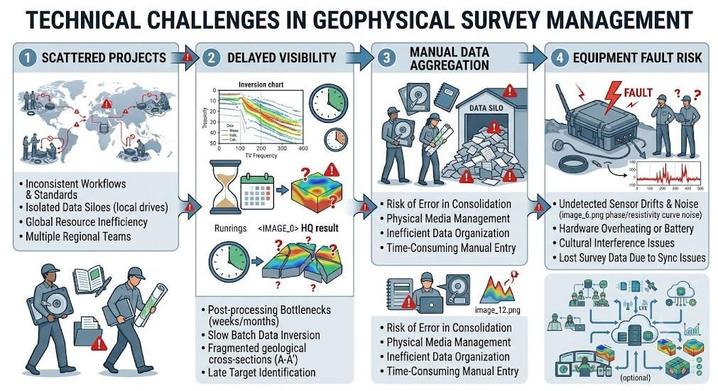
Traditional magnetotelluric exploration system equipment is largely standalone. Each station operates independently, and data is stored locally on the device. This structure creates four recurring management challenges.
1. Scattered Projects and Limited Visibility
Geophysical projects are often spread across mountains, deserts, construction sites, or remote exploration blocks. Each project may have multiple survey lines, dozens of stations, and several field teams.
In a traditional setup, managers cannot see all projects at a glance. They must contact each team separately for updates. This leads to delayed decisions, inconsistent reporting, and difficulty reallocating resources.
For example, if one project finishes ahead of schedule and another falls behind, managers may not notice quickly enough. They may miss opportunities to reassign personnel, instruments, or vehicles.
2. Difficult Centralized Data Aggregation
Traditional MT instruments store data locally on each acquisition unit. After field work, technicians must copy data from multiple devices, organize files manually, and upload them to a shared folder.
This process is slow and error-prone. File naming conventions may differ between teams. Important metadata, such as station coordinates, equipment serial numbers, and acquisition parameters, may be incomplete.
When multiple projects run in parallel, data aggregation becomes even more complex. Project managers spend extra time verifying data completeness instead of making decisions.
3. Lack of Real-Time Equipment Status Monitoring
In field operations, equipment health directly affects project progress. Battery level, storage capacity, sensor status, and signal quality can change during long deployments.
Traditional standalone MT equipment does not automatically report this information to headquarters. Teams may only discover a problem after returning to the station or receiving a delayed field report.
By that time, several hours of data may already be lost. The project may need rework, re-deployment, or emergency maintenance. This increases cost and delays delivery.
4. Poor Coordination Between Headquarters and Field Teams
Effective geophysical exploration requires close coordination between headquarters and field teams. Managers need to know where crews are, which stations are active, and whether data quality meets standards.
Traditional communication methods create gaps. Phone calls and messages may be delayed in remote areas. Field reports may be subjective and inconsistent. Headquarters cannot independently verify project progress.
This makes it difficult to maintain standardized operation across multiple teams. Different crews may follow different workflows, leading to inconsistent data quality and project performance.
Ⅲ. Three Management Values of Cloud-Connected MT Instruments
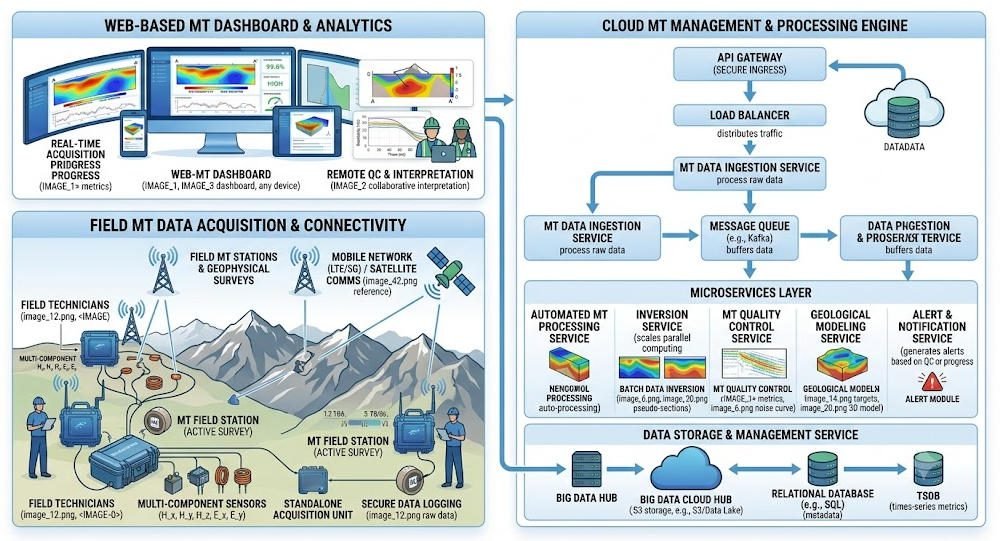
A cloud-connected MT platform transforms how geophysical projects are managed. It connects each magnetotelluric exploration system station to the cloud, enabling real-time monitoring, centralized data management, and coordinated team operation.
1. Real-Time Multi-Project Dashboard Visibility
The first value is centralized visibility. A cloud dashboard displays all active projects in one interface. Managers can see project locations, survey line progress, active stations, and equipment status in real time.
For example, a manager can check whether a station is still recording, whether battery level is sufficient, and whether data quality indicators are within acceptable limits. This reduces the need for constant phone calls and manual reports.
If one station stops unexpectedly, the system can send an alert. The management team can respond before the problem affects project delivery. This improves control over multi-project operations.
2. Centralized Data Management and Automatic Aggregation
The second value is automated data aggregation. A cloud-connected MT platform uploads field data to the cloud automatically. Files are organized by project, survey line, station, and time. Metadata is captured and stored consistently.
This eliminates much of the manual file handling work. Project managers do not need to wait for teams to return to base before reviewing data. They can check data completeness and quality remotely.
Centralized data also supports better teamwork. Geophysicists, project managers, and clients can access the same dataset from different locations. This reduces version control errors and improves collaboration.
3. Remote Equipment Health Monitoring and Alerting
The third value is equipment health monitoring. Cloud-connected MT instruments can report battery level, storage usage, sensor status, temperature, and signal quality to the cloud.
If an anomaly occurs, the system sends an alert to the responsible person. For example, if battery level drops below a threshold, the field team can be notified to replace the battery in time.
This reduces data loss caused by unexpected equipment shutdowns. It also improves maintenance planning. Managers can identify which instruments need calibration, repair, or firmware update before they are deployed to the next project.
Ⅳ. Efficiency Improvement Calculation Under Multi-Project Parallel Operation
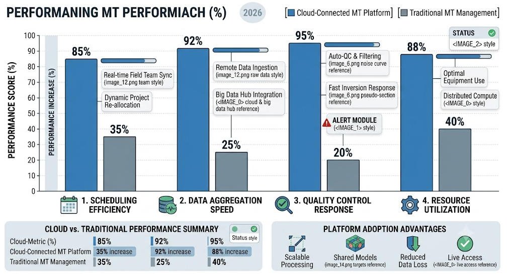
The practical value of a cloud-connected magnetotelluric exploration system becomes clear when multiple projects run at the same time. Efficiency improvements appear in scheduling, data management, quality control, and resource allocation.
1. Project Scheduling Efficiency
With real-time visibility, managers can schedule resources more accurately. They can see which projects are on track, which are delayed, and which teams have available capacity.
For example, if Project A completes its survey lines earlier than planned, the manager can reassign one crew and two MT stations to Project B, which is behind schedule. This reduces idle time and improves overall resource utilization.
In traditional management, this kind of dynamic adjustment is difficult. The cloud platform makes it visible and actionable.
2. Data Management Efficiency
Automatic cloud upload and metadata organization reduce manual data handling. Teams spend less time copying, renaming, and sorting files.
For a typical medium-sized geophysical project with 50 stations, manual data aggregation may take 4–8 hours per project. With a cloud-connected MT platform, this process can be largely automated.
When five projects run in parallel, the saved time becomes significant. Data can be reviewed, processed, and delivered faster to clients.
3. Quality Control Efficiency
Real-time data quality monitoring allows quality control to happen during acquisition, not after field work is completed.
If a station shows high noise, low signal, or unstable sensor data, the quality control team can identify the issue immediately. The field team can adjust electrode contact, check sensor orientation, or re-deploy the station before leaving the site.
This reduces rework and improves the percentage of usable data. It also helps maintain consistent quality across different projects and different teams.
4. Resource Allocation Efficiency
A cloud platform also improves instrument fleet management. Managers can see which magnetotelluric exploration system units are available, which are deployed, and which need maintenance.
This prevents overbooking of equipment. It also helps distribute instruments according to project priority. High-priority projects can receive better equipment and more experienced teams.
Over time, the platform can also provide historical usage data. Managers can analyze which instruments deliver the best performance, which projects take longest, and which teams achieve highest productivity.
Ⅴ. Conclusion: Cloud Platform Equipment Is a Must for Digital Upgrading
Geophysical exploration enterprises are under growing pressure to manage multiple projects efficiently. Traditional standalone MT equipment and manual management methods are no longer sufficient. They cause delayed information, scattered data, and limited control over field operations.
A cloud-connected MT platform solves these problems through real-time dashboards, centralized data management, and remote equipment monitoring. It improves visibility across all active projects and supports faster decision-making at headquarters.
For modern geophysical enterprises, a cloud-connected magnetotelluric exploration system is not just an IT tool. It is a core operational infrastructure. It improves multi-project parallel efficiency, reduces management risk, and supports the digital upgrading of field exploration operations.
Companies that adopt cloud platform MT equipment will gain clearer project control, faster data delivery, and stronger competitive advantage in multi-project environments.
FAQ
Q1.What is a cloud-connected MT instrument?
A cloud-connected MT instrument is a magnetotelluric exploration system that can upload field data, equipment status, and survey progress to a cloud platform. It allows project managers to monitor multiple field projects remotely from a central dashboard.
Q2.How does a cloud platform improve multi-project management?
A cloud platform provides real-time visibility, centralized data aggregation, remote equipment monitoring, and automatic alerts. It helps managers track project progress, allocate resources, and respond to anomalies faster than traditional manual reporting.
Q3.Can cloud-connected MT instruments work in remote areas?
Yes. Cloud-connected MT instruments are designed to work in remote field conditions. They usually support offline data storage and automatic synchronization when network connectivity becomes available again.
Q4.What management pain points does cloud-connected MT solve?
It solves scattered project visibility, slow data aggregation, delayed equipment fault detection, and poor coordination between headquarters and field teams. These are common pain points when multiple geophysical projects run in parallel.
Q5.Is cloud platform MT equipment suitable for small geophysical teams?
Yes. It is especially valuable for teams managing multiple projects or multiple instruments. Even small teams can benefit from centralized data storage, remote monitoring, and easier post-project data delivery.