Welcome to Geotech!
-1.png)


Dual-Sensor Proton Magnetometer in New Energy Exploration
TIPS:This technical guide presents the JPMG proton magnetometer for professional geomagnetic survey applications. It details how the proton magnetometer delivers precision measurement, and outlines geomagnetic survey workflows and geomagnetic survey deployment scenarios across mineral, archaeological and engineering sectors.
Ⅰ. Product Overview and Core Operating Principles
1. Product Definition
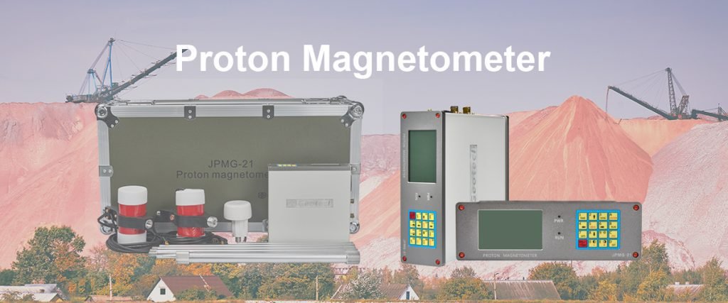
The JPMG Dual-Sensor Proton Magnetometer is a field-grade geomagnetic survey instrument designed for high-precision measurement of the Earth’s magnetic field. It detects subtle spatial variations in magnetic field intensity to infer subsurface geology, mineralization and structural features. The instrument uses proton precession technology to measure absolute magnetic field values with high accuracy and stability.
Proton magnetometers operate on the principle of nuclear magnetic resonance of hydrogen protons. A polarized proton sample precesses in the ambient magnetic field at a frequency directly proportional to field strength. Precise frequency measurement converts directly to magnetic field intensity values. This absolute measurement capability eliminates the need for frequent baseline recalibration.
The dual-sensor configuration adds gradient measurement capability and improves survey efficiency. Two matched sensors capture simultaneous measurements for vertical or horizontal gradient calculation. This configuration improves data quality, enables error checking and increases field productivity. The system meets IP67 environmental ratings and operates across extreme temperature ranges.
2. Core Technology Differentiators
The JPMG series incorporates several key technologies that set it apart from basic proton magnetometer designs. OCXO (Oven-Controlled Crystal Oscillator) frequency stabilization delivers industry-leading measurement accuracy. Military-grade component selection ensures reliability in harsh field conditions. Smart workflow features optimize field crew productivity and data quality.
Ⅱ. Technical Specifications and Performance Metrics
1. Core Performance Specifications
The following table summarizes key technical specifications for the JPMG dual-sensor proton magnetometer. These values define the instrument’s measurement capability and operational limits.
| Parameter | Specification | Note |
|---|---|---|
| Sensitivity | 0.05 nT | RMS noise level |
| Dynamic Range | 20,000 – 120,000 nT | Full-scale magnetic field range |
| Absolute Accuracy | ±0.1 nT | With OCXO temperature stabilization |
| Resolution | 0.01 nT | Minimum display increment |
| Gradient Tolerance | >5,000 nT/m | Maximum spatial gradient tolerance |
| Operating Temperature | -40°C to +55°C | Full operational range |
| Time Synchronization | 30 μs GNSS sync | GPS/BeiDou/GLONASS compatible |
| Internal Memory | 32 MB | Stores up to 69,905 readings in Base Mode |
| Environmental Rating | IP67 | Connector and casing rating |
| Console Weight | 1.57 kg | Field control unit |
| Sensor Weight | 1.0 kg each | Per sensor unit |
2. Measurement Stability and Environmental Performance
OCXO temperature compensation is the primary technology responsible for the instrument’s high absolute accuracy. The oven-controlled oscillator maintains stable reference frequency across temperature changes. This eliminates the drift that plagues standard TCXO-based magnetometers in variable field temperatures.
The system maintains specified accuracy across the full -40°C to +55°C operating range. This makes it suitable for both arctic desert and tropical field environments. Military-grade shock and vibration resistance ensures survival during transport and field deployment. IP67-rated connectors prevent moisture and dust ingress in harsh field conditions.
3. Positioning and Time Synchronization
Precise georeferencing is essential for meaningful magnetic survey data. The system integrates GNSS positioning with 30 microsecond time synchronization across multiple satellite constellations. It supports GPS, BeiDou and GLONASS for global operation flexibility.
Accurate time synchronization enables consistent data alignment across multiple sensors and survey lines. This is critical for gradient calculation, tie-line leveling and multi-day survey consistency. Sub-meter positioning accuracy supports high-resolution magnetic mapping and precise anomaly location.
Ⅲ. Dual-Sensor Configuration Advantages
1. Gradient Measurement Capability
The dual-sensor configuration enables direct measurement of magnetic field gradients. Two matched sensors separated by a fixed distance measure the field at two points simultaneously. The difference between readings divided by distance gives the vertical or horizontal gradient.
Gradient data enhances anomaly interpretation and reduces regional field effects. It helps separate local target anomalies from regional background variations. Gradient measurement also improves detection of small or deep-seated targets with weak surface expressions. This makes the system particularly valuable for mineral exploration and archaeological detection.
2. Data Quality and Error Checking
Dual sensors provide built-in data verification capability. Simultaneous readings from two matched sensors enable consistency checking. Measurements that diverge beyond acceptable tolerance can be flagged automatically.
This redundancy reduces the impact of sensor drift, temporary interference and measurement artifacts. It improves overall data reliability and reduces post-survey data cleaning requirements. Field crews can identify issues in real time rather than discovering problems during processing.
3. Field Productivity Improvement
Dual-sensor systems significantly improve field survey efficiency compared to single-sensor versions. They capture twice the data per survey line or enable simultaneous total field and gradient measurement.
| Performance Metric | Single-Sensor Version | Dual-Sensor Version | Improvement |
|---|---|---|---|
| Daily Station Productivity | 100–150 points/day | 150–200 points/day | ~50% increase |
| Gradient Measurement | Requires separate passes | Single pass measurement | Eliminates second pass |
| Data Redundancy | Single-channel only | Dual-channel verification | Built-in QA |
| Effective Cost per Point | Higher baseline | Lower effective cost | ~25% reduction |
The dual-sensor configuration reduces effective cost per data point while improving quality. It eliminates the need for separate gradient survey passes. This delivers both better data and lower total survey cost for most project types.
Ⅳ. Operation Modes and Field Workflow
1. Three Operating Modes
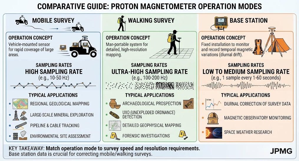
The JPMG magnetometer features three selectable operating modes optimized for different field scenarios. Each mode adjusts sampling rate, memory usage and power consumption to match survey requirements.
Mobile Mode uses 3–60 second sampling intervals for moving vehicle surveys. It balances spatial resolution with coverage speed for regional reconnaissance. This mode is typically used for ground vehicle and airborne magnetic surveys.
Walking Mode supports continuous walking surveys with the same 3–60 second sampling range. It is optimized for pedestrian survey crews on foot traversing survey grids. This is the standard mode for detailed mineral exploration and archaeological site surveys.
Base Mode extends sampling to 3–360 seconds for stationary base station operation. It provides longer averaging for higher precision monitoring applications. This mode serves diurnal variation monitoring and permanent reference station operation.
2. Real-Time Data Visualization
The system features real-time magnetic field visualization with live curve displays. Field operators can monitor data quality and survey progress during acquisition. This allows immediate identification of anomalies and adjustment of survey layout if needed.
Dynamic gradient measurement displays show both total field and gradient in real time. Crews can verify data quality and target response as they survey. This immediate feedback improves survey efficiency and reduces wasted effort over non-target areas.
3. Data Processing and Output
Dedicated processing software converts raw field data into contour maps and 3D magnetic profiles. It handles diurnal correction, tie-line leveling and standard data processing workflows. The software supports standard geophysical data formats for compatibility with interpretation packages.
Output products include total field maps, vertical gradient maps and interpreted anomaly products. Data can be exported in standard formats for integration with other geophysical datasets. Professional reporting templates support standard project deliverables.
Ⅴ. Key Application Sectors
1. Mineral Exploration
Proton magnetometers are standard tools for mineral exploration programs. They detect magnetic anomalies associated with magnetite-bearing ore bodies, sulfide mineralization and structural controls.
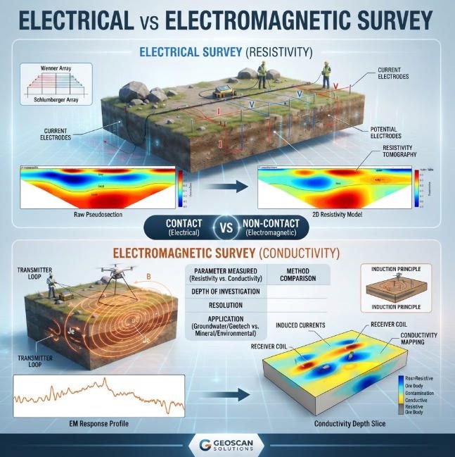
The system handles gradients up to 5,000 nT/m typical in mineralized terrains. It identifies subtle anomalies associated with disseminated mineralization and vein structures. Field case studies show good correlation between magnetic anomalies and mineralized zones confirmed by drilling. Combined with resistivity and IP methods, magnetic surveys reduce exploration risk and improve targeting.
2. Energy Sector
In the oil and gas sector, magnetic surveys support reservoir mapping and structural analysis. They help identify faults, folds and structural traps that control hydrocarbon accumulation. High-resolution magnetic data improves definition of subsurface structure.
Magnetic methods also support pipeline routing and underground infrastructure mapping. They detect buried metallic structures and associated geological features. This supports safe planning and reduces risk of unexpected conditions during excavation.
3. Environmental and Geohazard Monitoring
Magnetic monitoring networks support earthquake and volcanic precursor observation. Arrays of stations monitor temporal magnetic variations associated with tectonic activity. The system’s base mode supports permanent installation for continuous monitoring.
Time-lapse magnetic surveys also track subsurface changes associated with environmental processes. They support groundwater monitoring and subsurface flow characterization. High sensitivity detects subtle variations associated with fluid movement and property changes.
4. Engineering and Infrastructure Surveys
Engineering surveys use magnetic methods for pipeline detection and underground infrastructure mapping. They locate buried metallic utilities and structural features prior to excavation. This reduces risk of utility damage during construction projects.
The system also supports geotechnical site investigation through bedrock mapping. Magnetic signatures help identify lithological variations and bedrock depth. This complements other geophysical methods for comprehensive site characterization.
5. Archaeological Research
High-precision magnetic surveys detect buried archaeological features without excavation. They locate foundations, kilns, ditches and other relics through their magnetic signatures. The non-invasive nature makes the method ideal for heritage sites and protected areas.
The JPMG system’s high resolution identifies small and subtle archaeological features. Dual-sensor gradient data improves separation of archaeological features from background geology. This supports efficient non-invasive archaeological prospection and heritage management.
Ⅵ. Standard Configuration and Accessories
1. Standard Package Contents
The standard JPMG dual-sensor configuration includes all items required for field survey operation. The following table lists standard package components.
| Component | Quantity | Description |
|---|---|---|
| JPMG Magnetometer Console | 1 | Field control and data acquisition unit |
| Harness / Charger | 1 | Power and connection cable assembly |
| Sensor with Cable | 2 | Matched proton magnetometer sensors |
| Aluminum Rod (50cm) | 4 | Sensor mounting and spacing rods |
| Standard GPS Module | 1 | GNSS positioning and time sync |
| RS-232 Cable with USB Adapter | 1 | Data transfer and PC connection |
| Instruction Manual | 1 | Operation and maintenance manual |
| Shipping / Field Case | 1 | Protective transport and storage case |
2. Optional Accessories
Several optional accessories extend system capability for specialized applications. These include remote control interfaces, extended cable sets and alternative sensor configurations. Additional software modules are available for advanced processing and interpretation.
Ⅶ. Comparative Evaluation
1. Performance Class Positioning
The JPMG dual-sensor system occupies the high-performance professional tier of the proton magnetometer market. It delivers laboratory-grade accuracy in a field-portable instrument. Basic entry-level magnetometers offer lower sensitivity and fewer features at lower cost. Premium research-grade systems offer higher sensitivity at significantly higher price points.
2. Value Proposition
The dual-sensor configuration delivers better data quality at a modest price premium over single-sensor systems. Productivity improvements and reduced post-processing costs deliver lower total project cost. For most professional survey applications, the dual-sensor version provides the best balance of performance and value.
Ⅷ. Field Deployment and Quality Assurance
1. Survey Design Considerations
Successful magnetic surveys require proper design matching instrument capabilities to project objectives. Consider target depth, expected anomaly size, survey scale and required resolution. Line spacing should match expected target size and survey objective.
Station spacing depends on survey mode, walking speed and sampling interval. Proper tie-line procedures ensure data consistency across survey days and lines. Diurnal correction procedures account for natural temporal magnetic variations.
2. Quality Assurance Procedures
Standard quality assurance procedures ensure reliable, repeatable magnetic survey data. Repeat station measurements quantify data repeatability. Base station measurements provide diurnal variation correction. Sensor drift checks monitor instrument performance over time.
Dual-sensor systems enable built-in quality control through inter-sensor comparison. Measurements that disagree beyond threshold values can be flagged and investigated. This improves overall data reliability and reduces interpretation uncertainty.
Related Articles
Reference Sources
FAQ
Q1: What is a proton magnetometer used for?
A proton magnetometer measures the Earth’s magnetic field to detect subsurface anomalies associated with minerals, structures and archaeological features. It uses the proton precession principle for absolute field measurement. Common applications include mineral exploration, archaeological prospection, engineering surveys and environmental monitoring.
Q2: What is the advantage of a dual-sensor proton magnetometer?
A dual-sensor magnetometer measures magnetic gradient in a single pass and provides built-in data verification. It increases daily survey productivity by approximately 50% over single-sensor versions and improves data quality through redundant readings. This reduces total survey cost while improving anomaly detection capability.
Q3: How accurate is the JPMG proton magnetometer?
The JPMG dual-sensor proton magnetometer delivers ±0.1nT absolute accuracy with 0.05nT sensitivity across a 20,000–120,000nT dynamic range. OCXO temperature stabilization maintains accuracy across the full -40°C to +55°C operating range. 30μs GNSS time synchronization supports precise gradient and multi-line surveys.
Q4: What are the three operating modes of a proton magnetometer?
The three modes are Mobile (3–60s sampling for vehicle surveys), Walking (3–60s for pedestrian surveys) and Base (3–360s for stationary monitoring). Mobile mode serves regional reconnaissance; Walking mode serves detailed mineral and archaeological surveys; Base mode serves permanent monitoring and reference stations.
Q5: Can proton magnetometers detect mineral deposits?
Yes, proton magnetometers detect magnetic anomalies associated with magnetite-bearing ore bodies and sulfide mineralization. They identify both large structural features and subtle disseminated mineralization. Combined with other geophysical methods, magnetic surveys reduce exploration risk and improve drilling targeting success.