Welcome to Geotech!

Top 5 Electrical Resistivity Tomography Equipment Features You Should Know
Introduction
In the dynamic realm of geophysical exploration, Electrical Resistivity Tomography (ERT) equipment has emerged as a cornerstone technology, revolutionizing the way we peer into the Earth’s subsurface. As industries across the United States—from construction and environmental management to resource exploration—seek more accurate, efficient, and non-invasive methods for understanding underground conditions, ERT stands out as a versatile solution. Geotech Instrument Co., Ltd., a leading provider in geophysical survey equipment, offers cutting-edge ERT systems designed to meet the diverse needs of modern exploration projects. This article delves into the top five features of ERT equipment that are reshaping the landscapes of underground utility mapping, environmental monitoring, and geophysical surveys.

Importance of Electrical Resistivity Tomography
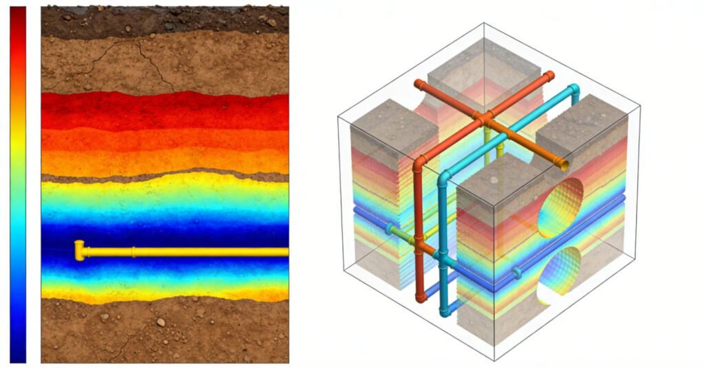
Electrical Resistivity Tomography is a geophysical imaging technique that measures the electrical resistivity of subsurface materials. By injecting an electrical current into the ground through electrodes and measuring the resulting voltage differences, ERT creates detailed 2D or 3D images of the subsurface resistivity distribution. This data is invaluable as different geological materials—such as soil, rock, water-saturated zones, and man-made structures—exhibit distinct resistivity signatures.
For industries in the United States, ERT provides a non-invasive way to gather critical information without the need for extensive excavation. Whether it’s identifying potential hazards before construction, monitoring environmental contamination, or mapping underground utilities, ERT’s ability to visualize subsurface conditions accurately reduces risks, saves time, and cuts costs.
Applications of Electrical Resistivity Tomography Equipment
ERT equipment finds wide-ranging applications across multiple sectors. In the construction industry, it is used to map the depth and location of bedrock, detect cavities or voids that could compromise building foundations, and locate underground utilities like pipes and cables. This helps prevent costly damages during excavation and ensures the safety and integrity of construction projects.
In environmental monitoring, ERT plays a crucial role in tracking the movement of contaminants in groundwater, identifying landfill boundaries, and assessing the effectiveness of remediation efforts. It enables environmental scientists to visualize subsurface changes over time, providing actionable insights for pollution control and ecological restoration.
Resource exploration companies leverage ERT to identify potential mineral deposits and study the geological structure of exploration sites. By mapping resistivity variations, geologists can infer the presence of valuable minerals and plan drilling operations more effectively.
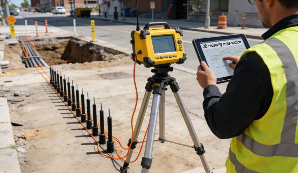
Feature 1: High Resolution Imaging
One of the most significant advantages of modern ERT equipment is its ability to deliver high-resolution imaging. Traditional geophysical imaging techniques, such as simple electrical resistivity soundings, often provide limited information about the subsurface, with low vertical and horizontal resolution. In contrast, advanced ERT systems from Geotech Instrument Co., Ltd. can achieve resolutions down to a few centimeters in favorable conditions.
This high-resolution capability has a profound impact on underground utility mapping. In urban areas of the United States, where underground infrastructure is complex and densely packed, accurately identifying the precise location, depth, and orientation of utilities is crucial. ERT’s detailed imaging allows engineers and contractors to create comprehensive utility maps, reducing the risk of accidental damage during construction projects. For example, in a recent urban renewal project in New York City, ERT equipment successfully mapped a network of aging water pipes and electrical cables, enabling the city to plan maintenance and upgrade work with minimal disruption to residents.
Feature 2: Versatility in Environmental Monitoring
ERT equipment demonstrates remarkable versatility in environmental monitoring applications. It can be integrated seamlessly with other environmental monitoring equipment, such as groundwater level sensors, soil moisture probes, and gas monitors. This integration allows for a holistic approach to environmental data collection, providing a more comprehensive understanding of subsurface processes.
In urban settings, ERT is used to monitor the spread of contaminants from industrial sites, landfills, or leaking underground storage tanks. By continuously imaging the subsurface resistivity, scientists can track the movement of pollutants in real-time and assess the effectiveness of containment measures. In rural areas, ERT helps in studying the impact of agricultural activities on groundwater quality, identifying areas vulnerable to nitrate leaching, and monitoring the recharge of aquifers.
For instance, in a large-scale environmental monitoring project in California’s Central Valley, ERT was combined with groundwater quality sensors to study the effects of irrigation on groundwater salinization. The integrated data provided valuable insights into the complex interactions between surface water, soil, and groundwater, guiding sustainable water management practices.
Feature 3: Non-Destructive Testing Capabilities
The non-destructive testing capabilities of ERT equipment offer significant benefits in geophysical surveys. Unlike invasive methods such as drilling, ERT does not require physical excavation or sample collection, minimizing disturbance to the site and reducing costs associated with site restoration. This makes it an ideal choice for sensitive environments, historical sites, and areas with limited access.
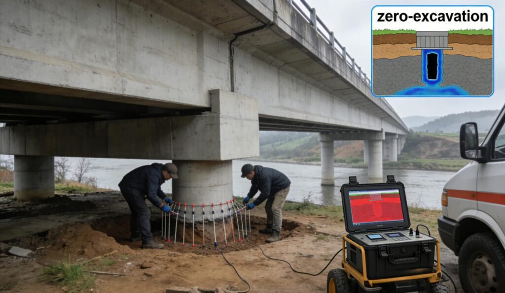
In case studies across the United States, ERT has proven its effectiveness in various scenarios. In a bridge foundation assessment project in Illinois, ERT was used to detect hidden voids beneath the bridge without the need for costly and time-consuming excavation. The non-destructive nature of the test allowed engineers to quickly identify potential structural issues and develop appropriate repair strategies. Similarly, in archaeological investigations, ERT helps map buried structures and artifacts without causing damage, preserving valuable historical information.
Feature 4: User-Friendly Software Integration
Modern ERT equipment is complemented by user-friendly software that simplifies data analysis and interpretation. Geotech Instrument Co., Ltd.’s ERT systems come with intuitive software platforms that can process large volumes of data quickly and generate detailed resistivity models. These software solutions offer features such as 3D visualization, data filtering, and inversion algorithms, which enhance the accuracy of subsurface interpretations.
The importance of software in enhancing operational efficiency cannot be overstated. It allows geoscientists and engineers to analyze data in real-time during field surveys, make immediate decisions, and adjust survey parameters if necessary. Additionally, the software enables the sharing of data and reports with project stakeholders, improving collaboration and communication. For example, in a large-scale mining exploration project in Nevada, the integrated software of ERT equipment enabled the exploration team to quickly analyze survey data, identify potential ore bodies, and plan subsequent drilling operations, significantly reducing project timelines.
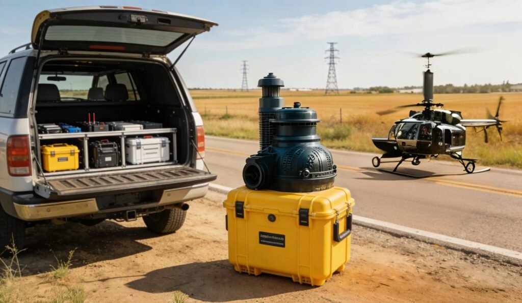
Feature 5: Portability and Field Applications
ERT equipment is designed with portability in mind, making it suitable for a wide range of field applications. Compact and lightweight systems from Geotech Instrument Co., Ltd. can be easily transported to remote locations, rugged terrains, and urban job sites. The equipment’s robust design ensures reliable performance in various environmental conditions, from extreme temperatures to high humidity.
In utility mapping projects, the portability of ERT equipment allows technicians to quickly survey large areas. For example, in a rural area of Texas where new utility lines need to be installed, the portable ERT system was deployed to map existing underground utilities efficiently. The ability to move the equipment easily between survey points reduced the time required for data collection and improved the overall productivity of the project. Similarly, in environmental monitoring applications, the portability of ERT enables scientists to conduct repeated surveys at different locations, tracking changes in subsurface conditions over time.
Conclusion
Electrical Resistivity Tomography equipment has become an indispensable tool in geophysical exploration, offering a range of features that address the diverse needs of industries in the United States. From high-resolution imaging for accurate underground utility mapping to non-destructive testing capabilities for sensitive environments, ERT’s versatility, user-friendly software integration, and portability make it a top choice for modern exploration projects. Geotech Instrument Co., Ltd.’s commitment to innovation and quality ensures that its ERT systems provide reliable, efficient, and cost-effective solutions for geophysical surveys, environmental monitoring, and construction projects. As the demand for accurate subsurface information continues to grow, ERT equipment will undoubtedly play an even more significant role in shaping the future of geophysical exploration.
References
- WIKI:https://en.wikipedia.org/wiki/Electrical_resistivity_tomography
- Society of Exploration Geophysicists (SEG) https://seg.org/
- Society of Environmental and Engineering Geophysicists (EEGS) https://www.eegs.org/
- Geology and Equipment Branch of China Mining Association http://www.chinamining.org.cn/
- International Union of Geological Sciences (IUGS) http://www.iugs.org/
- European Geological Survey Union (Eurogeosurveys) https://www.eurogeosurveys.org/

