Welcome to Geotech!

Application of comprehensive geophysical exploration methods in urban underground space detection
Description
Summary
The continuous development of China’s economy and the rapid advancement of urbanization have highlighted the urgency and importance of the demand for urban underground space detection and rational development and utilization. High-precision geophysical exploration methods play an important role in urban underground space detection. Compared with conventional geophysical exploration, urban underground space detection faces a more complex and special environment, so some fields have put forward higher requirements for conventional geophysical exploration. This paper attempts to summarize and sort out the application research progress and development trend in urban underground space detection in recent years. It summarizes the application progress of five methods, including urban high-density electrical method , ground penetrating radar method , surface wave exploration method , shallow reflection seismic method and urban high-precision gravity detection, covering electromagnetic, seismic, gravity and other comprehensive geophysical exploration methods, involving the application of fiber optic sensing and micro-motion technology in underground space detection, analyzing the advantages of various methods, and briefly expounding the effective methods and some existing problems of urban underground space detection, in order to provide a certain reference for the development of geophysical exploration related technologies and urban underground space detection.
0# Introduction
As a valuable natural resource, urban underground space has been widely developed and applied in developed countries and some developing countries around the world. With the continuous advancement of urbanization, urban underground space detection has become a hot topic of current research, and at the same time, higher requirements have been put forward for geophysical methods and technologies. Geophysical methods are an indispensable means for urban underground space detection, underground geological structure investigation and underground mapping. In recent years, major cities around the world have carried out urban underground space detection, and have used a variety of geophysical methods to solve a series of problems closely related to cities, such as geology, hydrology, environment and disasters, and have achieved good application results.
At present, geophysical detection methods and technologies are often used in engineering geophysical exploration in foreign underground space detection. Japan mainly uses surface waves and shallow seismic reflection exploration; Canada mainly uses geological radar, high-density resistivity imaging and shallow seismic exploration; Singapore mainly uses resistivity imaging, shallow seismic, logging and well geophysical exploration. For systematic urban underground space detection, it still needs to be further enriched and improved.
Compared with developed countries, China’s urban underground space exploration and utilization started late, but has developed rapidly. In the early days, urban underground space exploration was mainly carried out in combination with urban geological surveys and engineering surveys. In the 1960s, China organized urban geological surveys, including urban groundwater resource exploration, comprehensive engineering geological surveys, environmental geological surveys, and geological disaster surveys. In 1980, China used geophysical exploration methods such as aeromagnetic, gravity, resistivity, and radioactivity to carry out comprehensive regional geophysical exploration in more than 100 large and medium-sized cities, and basically explored the structural characteristics of large regional scales. In 2003, Beijing, Shanghai, Tianjin, Guangzhou and other large cities were selected as pilot areas for geological surveys. After that, a new round of multi-factor urban geological surveys including Hangzhou, Wuhan, and Nanchang were organized. These urban-scale underground space explorations have made comprehensive use of geophysical methods such as drilling, high-precision gravity and magnetic, electromagnetic methods, seismic longitudinal and transverse wave exploration, well logging, and well geophysical exploration, providing support for the construction of urban geological databases and the development and utilization of space resources.
Compared with conventional geophysical exploration, the detection environment of urban underground space is special, usually with dense buildings, busy traffic, serious environmental noise interference, small exploration range, dense exploration network, high shallow exploration accuracy requirements and high flexibility requirements. It needs to meet the requirements of efficient operation in narrow space, anti-interference and green environmental protection. Due to the different work characteristics and operation methods, it is not appropriate to simply apply oil and coalfield exploration technology. In terms of data collection and processing, higher requirements are put forward for conventional geophysical exploration, and traditional methods and technologies need to be gradually improved and perfected to meet the needs of urban exploration, improve anti-interference ability and actual detection effect. Some scholars have conducted a series of experimental studies on shallow seismic exploration under the background of urban interference, which has continuously improved the methods and technologies and promoted the development of the industry. This article attempts to summarize and sort out the research progress and development trends of the application of geophysical methods in urban underground space detection in recent years, covering multiple types of comprehensive geophysical exploration methods such as electromagnetic, seismic, gravity and cross-well geophysical exploration, involving the application of the latest fiber optic sensing and micro-motion detection technology in underground space detection, and summarizing the advantages of various methods, briefly explaining the effective methods and some existing problems in urban underground space detection, in order to provide some reference for the development of geophysical exploration related technologies and urban underground space detection work.
01# Basic principles, methods and detection targets of urban geophysical exploration
1.1 Basic principles of geophysical exploration
Geophysical exploration is based on the physical differences between the target body and the surrounding medium. It uses geophysical principles and corresponding advanced geophysical instruments and equipment to analyze and study the observed physical field distribution. Through data processing and comparison of anomalies, the corresponding relationship between the analysis and interpretation of the detected target body is used to explore geological boundaries, geological structures or other target bodies, or to determine the physical properties or engineering characteristics of geological bodies or underground artificial buried objects. Based on the changes in geological conditions and the changes in physical fields such as electric fields, seismic wave fields, magnetic fields, gravity fields, geothermal fields, and radioactivity caused by urban activities, various methods such as electrical methods, seismic methods, magnetic methods, gravity, temperature measurement, and radioactive exploration are used to explore the application effects achieved under different conditions such as land, water, and underground (wells and tunnels), and obtain physical properties including geological structures, groundwater, landslides, fluid fillings, and abnormal buried objects, in order to solve geotechnical engineering and environmental geological problems, and provide support for urban construction planning, space resource development and utilization, and healthy and sustainable urban development.
1.2 Geophysical exploration methods
At present, a variety of conventional and new geophysical methods are used in the exploration and investigation of urban underground space in China. Based on the differences in the source properties of geological bodies such as electric field, seismic wave field, magnetic field, gravity field, geothermal field, radioactivity, etc., the main technical methods currently covered include: ground penetrating radar, conventional shallow seismic (two-dimensional, three-dimensional), high-density electrical method, wide-area electromagnetic method, transient electromagnetic method, well geophysical technology (well seismic, well electromagnetic method, well logging), direct current electrical sounding, natural passive source surface wave exploration, mixed source three-component seismic frequency resonance exploration and other detection methods, especially micro-motion detection methods and distributed acoustic sensing technology (DAS) using optical fiber acquisition have received widespread attention and exploration development in recent years, and have been continuously enhanced in practice.
1.3 Geophysical exploration objectives
The content of geophysical exploration work in urban underground space is closely related to urban construction projects and urban environment. Specifically, the above-mentioned geophysical exploration techniques and methods can be used to study and solve the division of underground geological structures; confirm the cover layer, weathering zone, and bedrock burial depth; detect active faults and hidden structures; detect water-rich areas; detect hidden bays, karsts and voids; detect underground pipelines; investigate roadbed disasters and landslides; explore ancient river channels; select subway tracks and highways; select sites for major buildings (dams, power stations, etc.); detect and evaluate landfill leakage; evaluate urban pollution risks; evaluate hydrogeological conditions and determine dynamic parameters, and even archaeological surveys, environmental monitoring and restoration, etc., which are of great significance.
02# Research progress on the application of the method
As human activities and the ability to transform nature continue to increase, the impact of urbanization on the natural environment is also increasing, which may bring new disasters. Environmental and disaster issues deserve attention. In recent years, accidents such as road collapse and subway collapse in Chinese cities have occurred frequently. Cities are facing special geological risks such as ground subsidence, ground fissures, active faults and karst under special geological environments. It is necessary to carry out research on methods such as detection and monitoring technology of underground space in special geological cities as soon as possible. The following article will try to introduce geophysical exploration methods such as high-density electrical method, ground penetrating radar method, surface wave exploration method, shallow seismic method, high-precision gravity, etc., sort out and analyze the application progress and detection effect of different geophysical methods in urban underground space detection, and briefly explain the advantages and disadvantages of the methods, as well as some problems faced in actual work. Detection elements involve urban active faults and cracks detection, shallow surface structure and lithology parameter detection, underground pipeline and karst cavity detection, underground geothermal micro-motion detection and urban underground road detection.
2.1 High-density electrical method
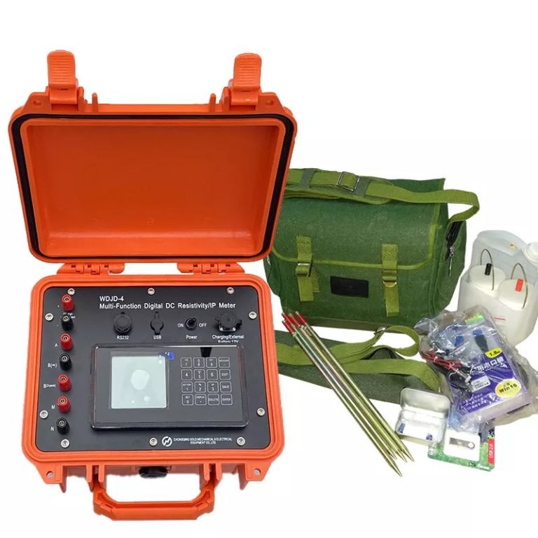
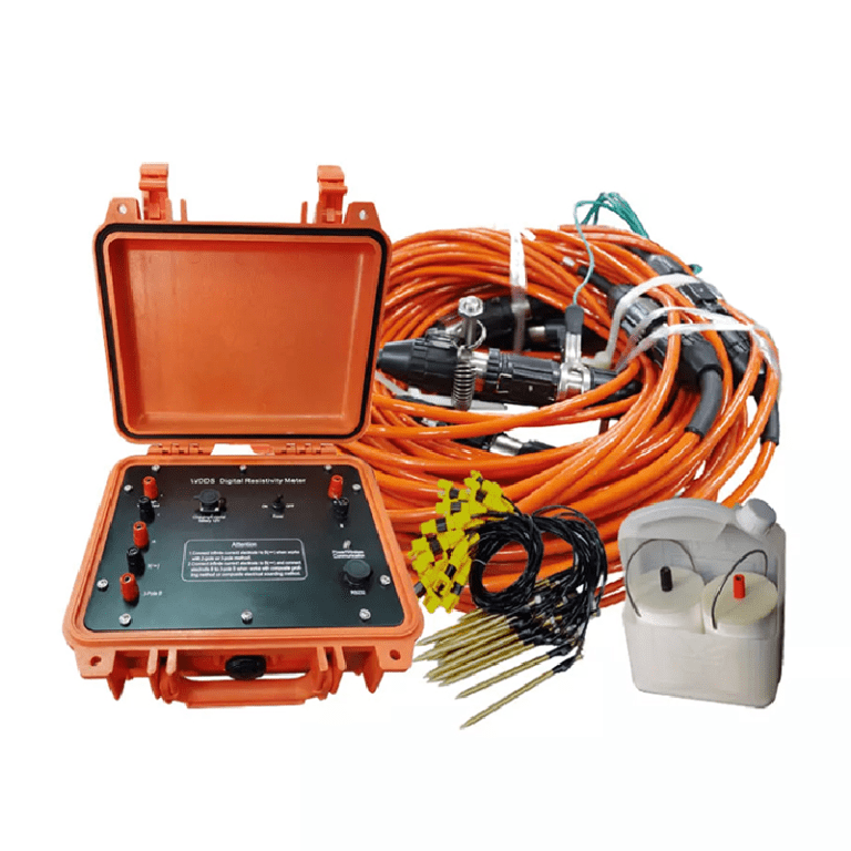
High-density electrical method is a geo-tomography technology that integrates electrical profiling and electrical depth sounding, based on the difference in electrical conductivity between rocks in different strata. Power is supplied to the underground through a set of electrodes, and another set of electrodes measures the voltage and current and introduces the device coefficient to obtain the apparent resistivity value, thereby inferring and interpreting the underground geological structure to achieve the purpose of exploration.
In the mid-1980s, Japan used automatic control theory and integrated circuits to achieve high-density electrical field data collection. In the late 1980s, China’s geological and mining circles began to study the theory and technical methods of high-density electrical methods. With the continuous development of computer hardware and technology, the application practice of high-density electrical methods has been continuously strengthened and matured. The application fields include: delineating aquifers, detecting cracks, cavities, dark bays and gypsum salt layers and other unfavorable geological bodies, and selecting roadbeds and bridge piers. Chinese geologists divided the high-density electrical point data into layers based on geological and drilling information, constructed a two-dimensional model inversion, and completed the step-by-step inversion study of high-density resistivity from one dimension to two dimensions, improving the inversion accuracy and geological interpretation accuracy. Chinese geologists used a combination of drilling exposure, experimental testing, multi-parameter geophysical logging, and ground geophysical exploration methods to carry out fine detection and modeling of underground space, obtained the multi-parameter geophysical characteristics of Xixian New Area, and proposed a combination method of urban underground space geophysical exploration combining high-density electrical methods, micro-seismic array observations, shallow seismic exploration and multi-parameter logging methods.


Gypsum-salt layer is a common adverse geological body in urban underground space. It is of great significance to know the depth and distribution of gypsum-salt layer in bedrock in advance. Geotech has carried out the exploration of gypsum-salt-rich layer using high-density electrical method, micro-seismic exploration, three-component frequency resonance exploration and other methods, and carried out 100mx10m scanning measurement in the study area using equivalent reverse flux transient electromagnetic method, inverted to obtain the three-dimensional electrical structure shallower than 200m, and combined with drilling information to infer the spatial distribution of gypsum-salt layer.
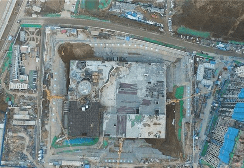
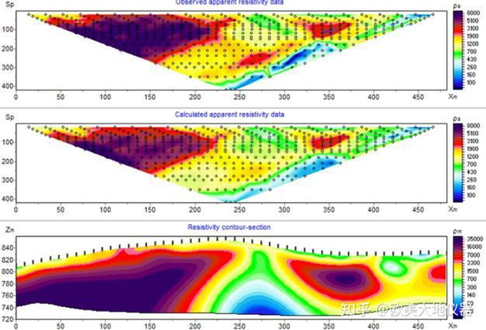
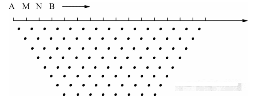
Geotech used the high-density resistivity method to detect and study the sand lens, hidden cracks and collapse developed in the Quaternary strata of Xiongan New Area from 0 to 200m. Combining the geological structure section and the high-density resistivity body depth slice, the distribution of the ancient river channel sand body was predicted. The data was measured using the Wenner α pole arrangement method (Figure 1) and the WDJD-2 high-density electrical method instrument. The electric dipole moment was 10m. A total of 13 east-west survey lines and 8 north-south survey lines were arranged in the survey area, distributed in a grid.
Data processing uses Res2dinv software and follows the processing flow of data editing – terrain correction – initial settings – forward modeling settings – inversion settings – inversion result output – Surfer mapping.
By carrying out three-dimensional modeling of the resistivity values inverted at a depth of 0-200m in the survey area, a resistivity depth slice with horizontal direction as the main direction and arbitrary direction as the auxiliary direction (as shown in Figure 2) is obtained. It is believed that: at a depth of more than -65m, the resistivity value range is 5 to 70Q・m, with more high values. It is speculated that there are large layers of fine and medium sands containing water, that is, there are multiple large-scale “sand layer lenses” that are continuously interconnected; while at a depth of less than -65m, the resistivity value range is 10 to 50Q・m, and the high values are reduced. It is speculated that clay, sub-clay, sub-sand soil and fine sand, silt sand, etc. are frequently deposited alternately to form interlayers of unequal thickness.

Compared with the traditional resistivity method, the high-density electrical method has many advantages:
- ①The electrode layout can be completed in one go, which is quick and convenient to operate and avoids errors caused by multiple layouts;
- ②It can efficiently measure a variety of electrode arrangements and realize multi-parameter measurement;
- ③Automatically complete data collection and collection;
- ④Data can be processed on-site in real time with high efficiency.
The problems faced by high-density electrical method in urban applications include: electromagnetic interference in urban environment is unfavorable to high-density electrical method, and it is not suitable to be used under high electromagnetic interference; there is a problem of coupling between electrodes and hardened ground, and the grounding conditions need to be effectively improved to ensure normal power supply and reliability of detection data; the measuring line is restricted by buildings and sites, etc.
2.2 Ground Penetrating Radar
The ground penetrating radar method transmits high-frequency electromagnetic waves ranging from tens of megahertz to several thousand megahertz through the ground, and analyzes and infers the underground medium structure and stratum lithology characteristics based on the amplitude and waveform of the received reflected electromagnetic waves. The premise of the application of the ground penetrating radar method is that there is a difference in dielectric constant between the strata. This difference in dielectric constant between the upper and lower layers determines the strength of the reflected signal during the propagation of electromagnetic waves underground.
Geotech combined the cases of underground pipeline detection and karst investigation, analyzed the comprehensive application effects of various detection technologies such as ground penetrating radar, and believed that technologies such as three-dimensional high-density shear wave seismic, three-dimensional high-density electromagnetic method, and three-dimensional ground penetrating radar are the development trend of urban underground space detection technology. Geotech uses full polarization ground penetrating radar to identify pipelines, which improves the previous method of single polarization radar that can only obtain single polarization data, and extracts the polarization attributes of any pipeline target in single and multiple pipeline targets, indicating that full polarization ground penetrating radar technology can obtain more comprehensive target body polarization information and can better identify pipeline targets whose polarization attributes are affected.
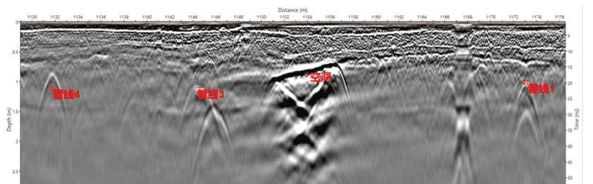
Geotech used electromagnetic induction, geological radar and acoustic detection methods to conduct underground pipeline distribution detection tests. Through the coordination and cross-validation of different methods, an accurate pipeline network distribution map was drawn. The radar image in Figure 3 reveals rainwater pipes, fire pipes, thermal pipe trenches and water supply pipes. The results show that the combination of appropriate detection methods and step-by-step test judgment can effectively solve the signal interference problem in close-range cast iron pipeline detection.

The mainstream geophysical method for detecting underground pipelines currently believes that electromagnetic induction has obvious advantages in detecting metal pipelines and can ensure high detection accuracy for small-diameter power and communication cables, while ground penetrating radar is the preferred method for detecting non-metallic pipelines. The two methods complement each other, but the anti-interference ability and instrument detection accuracy still need to be further improved. A new method for intelligent recognition of underground pipeline ground penetrating radar images based on hash algorithm fully utilizes the advantages of hash algorithm in simplicity and speed, and combines K-means clustering analysis of constraint vectors to achieve rapid recognition of pipelines in ground penetrating radar profiles; and proposes a pipeline material discrimination method based on brightness function to solve the problem of difficulty in distinguishing pipeline materials from ground penetrating radar profiles.
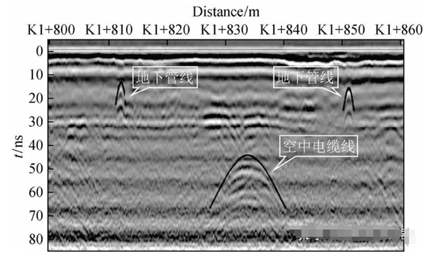
The ground penetrating radar acquisition parameter setting and data quality evaluation method were compared and studied. The ground penetrating radar wave group characteristics of normal roads, typical interference sources and typical road hidden diseases were compared. It was found that the diffraction wave hyperbola curvature of the overhead cable was small, and the two wings were gentle and long, while the diffraction wave hyperbola curvature of the underground pipeline was large, and the two wings were steep and short (Figure 4). Therefore, its position and burial depth were delineated, which provided guidance for taking repair measures and eliminating the hidden dangers of collapse.

The ground penetrating radar method has the advantages of high precision, high efficiency, continuous non-destructiveness, and real-time imaging. It is currently used in urban underground space detection for underground pipeline detection, underground adverse geological body detection, archaeology and groundwater detection. Its main problems are interference from complex electromagnetic waves in the city and shallow detection depth.
2.3 Surface wave exploration method
Surface wave exploration based on the excitation method includes active source surface wave exploration and passive source surface wave exploration.
2.3.1 Active surface wave exploration
Active source surface wave exploration usually uses linear arrays and can be divided into steady-state method and transient method. Steady-state surface wave exploration receives single-frequency sine waves excited by the source by continuously moving the detector. Transient surface wave exploration usually uses multi-channel surface wave analysis technology. The transient source excites a wide-band pulse. Surface waves of different frequencies propagate underground in the form of pulses and are received by detectors evenly arranged at a fixed track spacing on the survey line. The surface wave data is analyzed in the frequency domain. By inverting the dispersion curve, the phase velocity of surface waves of various frequencies near the surface is obtained, thereby obtaining the shear wave velocity model. Commonly used methods include surface wave spectrum analysis and multi-channel transient analysis.
Since the multi-channel surface wave analysis method was proposed at the end of the last century, domestic and foreign scholars have conducted a lot of research, and it has been widely used in the field of engineering exploration in recent years. Geotech combined active and passive source surface waves to conduct stratigraphic surveys and studies on the Weihe River Basin, improving the imaging accuracy. Distributed fiber optic sensors were used to conduct active source surface wave exploration experiments, and multi-channel surface wave analysis technology was used to extract dispersion curves and obtain shallow velocity, providing new data acquisition instruments and equipment for surface wave exploration. Geotech used multi-channel surface wave analysis methods to conduct geological structure detection at the boundary of Baotu Spring, combined first-arrival wave tomography with surface wave dispersion analysis methods, established longitudinal wave velocity, transverse wave velocity and longitudinal and transverse wave velocity ratio models, obtained the shallow 0-80m stratigraphic structural characteristics, and inferred the direction of the spring boundary runoff channel, providing new technical support for Jinan rail transit construction and underground space resource development and utilization.
2.3.2 Passive surface wave exploration (micro-motion detection)
Intelligent micro-motion exploration technology does not require artificial seismic sources and has the characteristics of being non-destructive, efficient, convenient, safe, economical, environmentally friendly, and having a large exploration depth. It has obvious advantages and good application prospects in urban underground space detection.
At present, the microseismic array technology is based on the theory of stationary random processes. It obtains natural vertical downward microseismic signals through a specific observation system, extracts surface wave dispersion curves from them, and performs attribute inversion on the dispersion curves. Microseismic array technology has natural anti-interference ability because it adopts the strategy of collecting long-period microseismic signals and then extracting dispersion curves from stationary signals. This is suitable for complex urban environment exploration. However, due to the weak high-frequency energy in microseismic signals, the resolution of shallow stratigraphic structures is poor; since this method is usually based on the average dispersion spectrum calculated between signals at multiple observation points in irregular directions, the dispersion spectrum lacks convergence or the overall velocity is too large, and the obtained dispersion curve velocity value is far from the actual surface wave velocity. In addition, the larger the space for the device to be arranged, the greater the error, which ultimately leads to reduced detection accuracy. Figure 5 shows different types of observation systems for the microseismic array method, among which the linear type and the embedded triangle type are the most commonly used.


The microseismic sounding method mainly includes three parts: raw data collection, phase velocity dispersion curve extraction and shear wave velocity inversion. The spatial autocorrelation method (SPAC) is usually fast and effective. The SPAC method and the background noise cross-correlation method (NCF) in passive source exploration are physically consistent. One is a description in the frequency domain and the other is a description in the time domain. The SPAC method obtains the average dispersion curve of the entire area below the arrangement, while the dispersion curve obtained by the NCF through the cross-correlation function is the average effect on the path between any two stations. The SPAC method requires a relatively regular circular array to be collected. When the collection conditions in the city are limited and it is difficult to use a regular circular array, the extended spatial autocorrelation method (ESPAC) can be used. Geotech arranged 45 microseismic sounding points, and used the extended spatial autocorrelation method (ESPAC) to extract the Rayleigh wave dispersion curve from the vertical component, and used the genetic algorithm to obtain the S-wave velocity structure, effectively detecting the thickness of the Cenozoic cover layer, providing a scientific basis for geological disaster prevention and control and geothermal resource utilization.
Geotech continuously recorded 15 hours of seismic background noise data through short-period seismometers (triple circular acquisition array as shown in Figure 6), and used the spatial autocorrelation method (SPAC) to test the phase velocity of the low-frequency part of the dispersion corresponding to the aperture size of the 50m, 100m and 200m arrays. The Rayleigh surface wave dispersion curve of the observation point was extracted by fitting (Figure 7), and the S-wave velocity structure profile of the area was obtained by inversion using the surface wave tomography method. The water-rich area was divided by two low-velocity anomaly zones on the profile (Figure 8), which provided a reference for geothermal exploration research.


Many ancient buildings have serious safety problems such as tilting and collapse due to deformation of the foundation. It is necessary to detect the foundation of ancient buildings and conduct safety evaluation. The background noise imaging method was used to conduct ultra-high density non-destructive detection of the foundation of Dengfeng Observatory in Henan Province. Six survey lines were arranged around the observatory to collect 24h data for cross-correlation calculation. The superposition results showed that the foundation of the observatory was well stratified and there was no low-speed anomaly, which was consistent with the situation of the exploration trench. It was inferred that the foundation structure was solid and stable. Urban ground subsidence can easily cause ground cracks or even collapse , causing safety accidents. The micro-motion method was tried to explore the cause of ground subsidence. The collected micro-motion data was extracted using the FK method for dispersion curves, and the underground shear wave velocity structure was inverted. Combined with geological drilling for verification, the location and scale of the underground uncompacted soil were detected, and the occurrence of secondary accidents in the subsidence area was successfully ruled out.
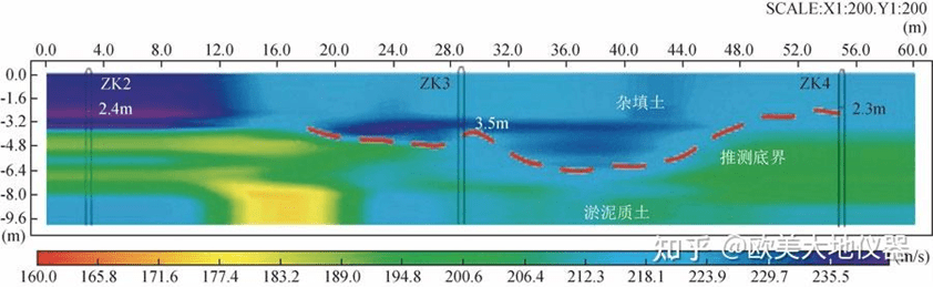
With the development of cities, surface rivers and streams are filled with gravel, clay and garbage to form hidden streams, which are adverse engineering geological phenomena and need to be eliminated. In view of the hidden stream exploration problem of Ningbo rail transit, the effectiveness of three geophysical exploration methods, namely micromotion profile detection method, transient Rayleigh wave method and high-density electrical method, in detecting hidden streams was studied respectively. The locations and buried depths of hidden streams inferred by the three methods are relatively consistent. Figure 9 shows the apparent S-wave velocity profile and inferred range of 1-line micromotion detection, and Figure 10 shows the apparent velocity diagram and interpretation area of 2-line transient Rayleigh wave.

The shallow seismic exploration technology of mixed source surface wave and three-component frequency resonance was used to detect shallow geological structures in Chengdu Bio-City. This method has the advantages of high detection accuracy of active source surface wave and large detection depth of passive source surface wave, and obtains the three-dimensional S-wave velocity characteristics of the shallow stratum structure below 60m, improves the resolution and accuracy of detection, and realizes the fine division of the stratum structure. The vibration and noise characteristics of the complex urban environment interference were analyzed, and the surface wave imaging was performed using automobile vibration noise, and the reasonable stratum wave velocity structure underground was obtained. It is believed that a reasonable observation system, reasonable analysis of effective signals and observation time are crucial.
The micromotion H/V spectrum ratio method, also known as the single-point H/V spectrum ratio method or the Nakamura method, is an exploration technology for inverting stratigraphic properties based on the spectrum ratio characteristics of the horizontal and vertical components in the single-point three-component data. This method is simple, economical, and has no interference with the environment. It is suitable for urban applications. The velocity obtained is essentially the true stratigraphic velocity, has anti-interference ability, and is highly accurate, but it is more dependent on the initial velocity model. The micromotion H/V spectrum ratio method was selected to carry out three-component micromotion measurement research on the soil-rock interface in the central urban area of Jinan . The relationship between different types of H/V curves and geological structures was analyzed using data from more than 400 measurement points. The depth-frequency relationship of the bedrock was summarized, and a fast and accurate solution for the depth of the soil-rock interface was provided. The natural source surface wave technology was used to conduct urban geological survey experiments. By measuring the surface wave velocity structure of a single point, the stratigraphic structure in the area was finely divided, and a number of engineering geological parameters were obtained, verifying the effectiveness of the natural source surface wave technology in the urban environment.
The exploration of deeper layers can be achieved by combining active source and passive source technologies and appropriately increasing the array length and acquisition time. The active source method relies on body waves and high-frequency surface waves for high-precision imaging, and the construction cost is high. The passive source surface wave imaging method is low-cost and mainly uses the cross-correlation function of seismic background noise for imaging. This method has been increasingly used in shallow urban imaging. High-order Rayleigh surface waves are more sensitive than low-order modes and can be used in combination. A large number of seismometers are required to deploy high-density seismic observation arrays within the city, and the deployment and maintenance costs limit its promotion. Distributed acoustic sensing technology (DAS) developed in recent years is a seismic observation system composed of sensing optical fiber and optical signal demodulator. It monitors the dynamic strain of optical fiber by measuring the phase change of backscattered light in the optical fiber, and then realizes the recording of seismic wave fields. The system can achieve ultra-dense observation at a low cost and is expected to improve the accuracy of shallow velocity structure imaging. Its unique information perception capability has made DAS technology widely concerned. Its rapid development has demonstrated unique technical advantages and potential in security intrusion detection, geophysical exploration, etc. Wang Baoshan et al. (2021) used signals recorded by underground communication optical cables to identify different vibration signals such as vehicle movement, air gun seismic sources, and artificial falling hammers, and successfully extracted surface wave signals from the background noise recorded by the optical cable, and obtained the shear wave velocity structure within 200 m of the surface, providing a new observation technology for the detection of urban fine structures.
2.4 Shallow reflection seismic method
Shallow reflection seismic is a geophysical method for detecting shallow geological bodies by artificially exciting seismic waves, analyzing their kinematic and dynamic properties in underground media, exploring the laws of seismic wave propagation, studying shallow structures and sedimentary characteristics, etc. With the emergence of digital seismographs and the emergence of multiple coverage technology, the anti-interference ability, detection accuracy and resolution have been improved. According to the type of seismic waves excited by the source and the type of data processed, shallow reflection seismic can be divided into longitudinal wave reflection technology and transverse wave reflection technology.
2.4.1 P-wave reflection earthquake
P-wave reflection seismic uses seismic sources to excite P-waves and processes and interprets data. It accounts for the vast majority of seismic exploration and can be used for urban active fault detection , exploration of goaf and karst areas, and civil air defense projects. Active faults refer to faults that have been active during the Quaternary period, especially since the late Pleistocene, and may still be active in the future. A large number of earthquake disaster surveys have shown that active faults are not only the source of natural earthquakes, but also the most serious damage along the fault line when an earthquake occurs. Urban active fault detection is a complex and innovative task, and it is an arduous task faced in the new stage of active tectonic research and development. The urban environment and human activities bring many difficulties and problems to this work. Artificial seismic exploration is currently recognized as one of the most effective methods for detecting hidden urban faults. When conducting urban reflection wave seismic exploration, data collection is often limited by the urban excitation environment and background interference. Seismic exploration using high-power spark source excitation was carried out, and the excitation energy, discharge water depth, imaging effects of different sources were comprehensively compared to obtain the best excitation parameters. The seismic data has a high signal-to-noise ratio, confirming the effectiveness of spark source excitation seismic exploration in urban water networks, and has a good effect on the detection of hidden faults in cities. The precise positioning method of urban seismic active faults uses controllable seismic sources for frequency scanning, and cross-correlates the scanning signal and the vibration signal to effectively suppress the strong vibration interference in the city, and uses high-resolution seismic and electrical exploration to jointly locate the strike-slip fault. The three-component forward modeling of the wave equation is used to guide the design of the seismic observation system. Pseudo-random controllable seismic sources are used to collect high-precision seismic data under strong urban noise. The offset profile clearly reveals the location of the Huangzhuang-Gaoliying fault, providing a basis for clarifying the thickness of the Neogene strata on both sides of the fault. Using high-density electrical method, high-resolution seismic and gravity and magnetic methods, and adopting new data processing technology under adverse interference from urban areas, we have achieved relatively ideal results in detecting the location, occurrence and morphology of active faults. However, small faults with loose structure, weak cementation and slight deformation in the Quaternary system need further study. The resolution of shear waves and the selection principles of observation system parameters are analyzed from theoretical and experimental perspectives. The observation system of shear waves is determined through experiments to explore the wave group characteristics, fault distribution and burial depth of the Quaternary system in a certain city. The reflection wave tomography technology is used to explore the ground fissures in a certain city , and the location and direction of the ground fissures near the surface are preliminarily obtained, which provides a new idea for the successful detection of urban ground fissures. The inter-well velocity distribution is studied by using curved ray tracing and LSQR algorithm, and the stratigraphic structural information within the well control range is obtained. The inter-well seismic technology is used to accurately detect the fracture zone and underground buried air-raid shelters.
The tamping source was used for seismic acquisition. The rich reflection information in the middle was obtained with 3m trace spacing, 6 coverage observation system and 60Hz geophone reception. The reflection wave group was concentrated between 100-150ms, and the fault characteristics were obvious. The upper fault was buried about 90ms, but the shallow reflection wave information was lost (Figure 11a). In order to further obtain detailed information in the shallow part, the ultra-shallow exploration was carried out in the same fault point section with 1m trace spacing, 9 coverage and 100Hz high-frequency geophone reception. The reflection wave group was concentrated between 10-100ms, the shallow reflection wave group was rich, the fault characteristics were obvious, and the upper fault was further determined to be buried about 40ms, but the middle reflection wave information was seriously lost (Figure 11b). The results show that in order to accurately determine the location and nature of the fault, especially the active characteristics of the fault, different trace spacing, arrangement length and coverage times should be used to obtain the reflection wave information in the middle and shallow parts, conduct comparative analysis and determine the characteristics of the fault.

The spatial distribution of faults was determined by applying the joint profile method and seismic exploration, and the relative activity of faults was analyzed by combining the high-density electrical method, which effectively solved the problems of detecting hidden faults and evaluating seismic activity. Shallow reflection seismic technology was used to identify the stratigraphic information and distribution morphology of the Nenjiang Formation above the Keshan-Ya’an Fault in a certain urban area, and the characteristics of secondary faults developed on the main fault and the fault-fold structural system in this area were determined. Geologists used the land sonar method to use single-point measurement and extremely small offset distance excitation and reception, avoiding the wide-angle reflection problem caused by large offset distances in shallow exploration, overcoming noise interference on the road, and combining physical and numerical simulation research to explore the rock layer, fault and karst information in the old city of Jinan.
By adopting high-precision seismic exploration technology and exciting with small-tonnage controllable vibrator, and combining the test parameters such as the number of vibration stations, vibration times, sweep frequency range, drive level and offset distance, we obtained high-quality seismic data. The reflection wave group characteristics of the data are obvious and continuous, which effectively reveals the stratigraphic structure and burial depth characteristics.
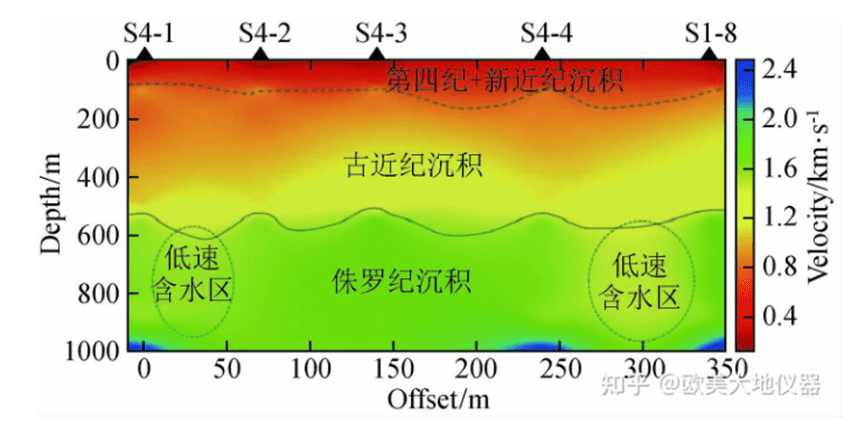
Three-dimensional seismic exploration plays an important role in the exploration of urban underground space. Spark sources are safe, economical, environmentally friendly, and have high energy conversion efficiency. By comparing and optimizing the excitation factors (excitation energy, excitation well depth) of spark sources, urban three-dimensional seismic exploration was carried out, and high-quality seismic data was obtained to explore the underground geological structure. Node + wired joint acquisition was used to conduct high-density and wide-azimuth urban three-dimensional seismic exploration, with more than 1,000 urban coverage times, 1.6 million coverage times/km2, and an aspect ratio of more than 0.9, achieving good exploration results. This is the largest urban three-dimensional seismic work in China with the largest seismic exploration area.
2.4.2 Shear wave reflection earthquake
Shear wave reflection seismic uses the source to excite shear waves and process and interpret the data. Seismic shear waves are not affected by water saturation and have high detection accuracy. They can make up for the shortcomings of longitudinal wave reflection in shallow exploration to a certain extent. Chen Xiangfu and An Xifeng (2007) used a heavy hammer to hit the iron plate horizontally in both positive and negative directions to excite, and used Summit digital seismograph and 28Hz shear wave detector to receive. After three vertical stackings, they obtained a relatively ideal single shot record (as shown in Figure 12), and divided the stratigraphic layers according to geological interpretation and wave velocity logging (as shown in Figure 13). The analysis shows that most rock and soil layers have a good correspondence with the reflection interface, which reflects the advantages of shear wave exploration in the sequence division and thickness detection of Quaternary loose layers, and makes up for the shortcomings of longitudinal wave shallow exploration.


Taking advantage of the high resolution and strong stratification ability of shear wave reflection, combined with seismic tomography to invert the velocity structure of the formation, the characteristics of active faults with thin local cover layers in Xinyi City were revealed, which made up for the shortcomings of longitudinal wave reflection in shallow exploration and improved the exploration accuracy. High-resolution shallow longitudinal and transverse wave seismic joint exploration test research was carried out. The longitudinal wave data was collected by broadband controllable source excitation, and the shear wave data was collected by hammer excitation, with intermediate blasting and small track spacing reception. Through fine data processing, information such as structure, lithofacies and velocity was obtained.
At present, artificial seismic exploration is recognized as one of the most effective means of detecting hidden faults in cities. Due to the limitations of urban environment, seismic data collection is often difficult. For cities with developed water networks, electric spark source excitation detection can be adopted according to local conditions. In the future, under the condition of meeting the output requirements, the source itself can be improved, and miniaturized hydraulic controllable source and lightweight electromagnetic controllable source can be developed. At present, there is still a certain gap between China’s geophysical instrument equipment and developed countries. Combined excitation is adopted, and the number of vertical stacking is appropriately increased to suppress interference. The towed cable system is one of the important forms of future urban exploration. It solves a series of problems such as towed cable structure and detector coupling. For example, a triangular base suitable for cement ground is used in the acquisition to maintain coupling, and a complete urban seismic exploration system including source system, towing system, data acquisition and processing is improved to achieve high-resolution exploration of shallow urban layers. In addition, due to the influence of surface obstacles and buildings in urban areas, the detectors cannot be arranged regularly, and the collected seismic data have missing channels, which often affects the processing and interpretation of seismic data. We explored the application of compressed sensing technology to reconstruct shallow urban earthquake data, and achieved good results with both simulated and actual data. In the future, compressed sensing technology can be applied to urban earthquake exploration to solve the problem of data reconstruction.
The use of small track spacing in seismic exploration provides an effective way to explore the shallow geological structure of cities. In the future, in-depth research is still needed in the propagation law of near-surface seismic wave fields and the energy absorption and attenuation mechanism, joint inversion, full waveform inversion, surface wave imaging, etc., to eliminate the adverse effects of the near surface on the seismic wave field and obtain a more accurate near-surface structure and parameter model. Since the shallow velocity of shear waves is relatively small, static correction problems will be more prominent for terrain with large undulations or complex surfaces, and will be greatly affected by static correction. Therefore, static correction work needs to be done carefully.
2.5 High-precision gravity method
High-precision gravity measures the slight gravity anomaly changes caused by the uneven density of underground media by arranging dense measuring points in a small area, establishes the depth and scale of the anomaly area through data processing, and converts it into a reasonable geological interpretation. Compared with conventional gravity methods, the detection range of high-precision gravity is generally smaller, but the density of measuring points and detection accuracy are higher. China introduced high-precision gravimeters in the 1980s and conducted application research in the fields of geodynamics, foundation exploration, archaeological exploration, etc. With the improvement of instrument accuracy and the advancement of data processing methods and technologies, the application of high-precision gravity methods is becoming more and more extensive, and can be expanded from the ground to shafts and tunnels and even inside buildings for measurement. For gravity data processing, in addition to conventional height correction, intermediate layer correction, and terrain correction, building correction is also required. Usually, an equivalent model is established by forward modeling to eliminate the impact of buildings. A rapid detection method for urban underground cavities based on a vehicle-mounted gravity measurement platform is proposed. A vehicle-mounted mobile platform is built using a domestic high-precision strapdown gravimeter. A dynamic gravity measurement test is carried out in a certain city . The gravity anomaly data is imaged using the improved ratio DEXP (depth estimation of extreme points) method, and the boundaries of the potential field data are identified. The outliers and structural indexes near the area are obtained, which verifies the effectiveness of gravity measurement by the vehicle-mounted mobile platform in the detection of urban underground cavities.
The application research results of high-precision gravity in urban underground space detection are introduced from the aspects of gravity detection device, high-density data acquisition, fine data processing and interpretation, including reading time under interference, three-dimensional coordinate acquisition, terrain correction method, abnormal data calculation, inversion method and interpretation results. The instrument adopts a new generation of high-precision gravimeter (accuracy greater than 0.001×10⁻⁵m/s2), which can identify urban micro-Gal anomalies (within ±0.050×10⁻⁵m/s2). In order to avoid the influence of high-rise buildings in the city, RTK measurement is used for geodetic work 30m away from high-rise buildings, and optical leveling is used within 30m. In order to eliminate the elevation difference between different measuring points, the height difference from the ground to the bottom of the instrument is measured before measurement and taken as 0.1cm to eliminate the field value anomaly in this part. In the near-area land modification, 1mx1m or 2mx2m grids are generated by DEM using actual GPS geodetic elevation data to ensure the elevation node error. The correction of the intermediate layer density is generally obtained by taking the average value of samples collected on site in the study layer or by calculating the gravity field at different density values.
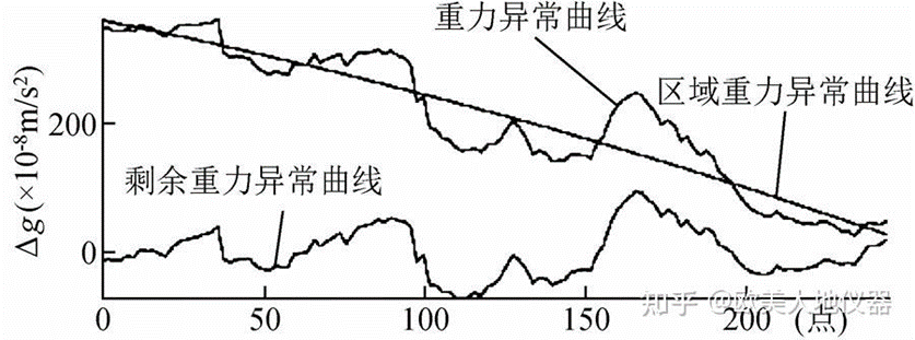
In data processing, commonly used methods include polynomials, trend surfaces or nonlinear methods such as different spectra to separate gravity anomalies. Figure 14 is a residual gravity anomaly map extracted by polynomials, and Figure 15 is a residual gravity anomaly map extracted by trend surface method. Figures 15b and 15c are residual gravity anomaly maps and regional gravity anomaly maps of third-order trend analysis, respectively. In terms of data inversion, for layered density interfaces, the least squares linear regression method or Parker method can be used to determine the single density interface; or RGIS gravity, magneto-electric data processing software can be used for multi-interface and multi-parameter iterative fitting. At present, domestic RGIS and MAGS software are relatively mature, including RGIS software three-dimensional manual interactive inversion, etc. Human-computer interactive inversion with detailed physical conditions and drilling control is the optimal inversion interface method.
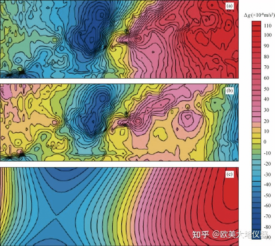
(a) Gravity anomaly map of an underground tunnel at a passenger station; (b) Residual gravity anomaly map; (c) Regional gravity anomaly map
High-precision gravity does not require drilling to lay electrodes or detectors. It has the advantages of convenient data collection, low cost, green environmental protection, and anti-interference. It is widely used in urban underground space, archaeological exploration, cavity detection, groundwater migration, etc., and is irreplaceable under certain conditions.
03# Method Comparative Analysis
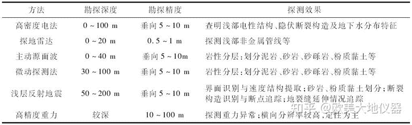
At present, the humanities in urban environments are highly disturbed. Urban geophysical exploration involves ground detection, engineering testing, and well detection. Due to unfavorable conditions such as site and environmental interference, as well as high safety and environmental protection requirements, traditional geophysical methods cannot be effectively carried out in cities. Urban underground space exploration still faces many scientific problems and technical difficulties. These include anti-interference problems, geological structure detection under water bodies, the impact of near-surface on seismic wave fields, and insufficient resolution of shallow detection. At present, the accuracy of geophysical detection is insufficient, drilling and geophysical exploration technology is insufficient, and the exploration accuracy and depth have certain limitations. A full-factor detection system can be established based on vertical spatial distribution. In addition to insufficient resolution of shallow detection, how to eliminate the impact of near-surface on seismic wave fields. To further enhance anti-interference capabilities and improve comprehensive detection effects, it is still necessary to summarize and improve method awareness. Urban underground space exploration is a systematic project, and multiple method tests and comprehensive geophysical exploration can be carried out to effectively cooperate and reduce the multi-solution of a single method. Electromagnetic and seismic joint inversion is currently mainly aimed at deep oil and gas exploration. It has not been reported in the interpretation of urban underground space detection, and faces new opportunities. Table 1 shows the commonly used geophysical detection methods and effects of urban underground space.
04#Conclusion and Outlook
The detection of urban underground space is rich in content and covers a wide range. The urban geophysical exploration methods described in this article mainly include high-density electrical method, ground penetrating radar, surface wave exploration (active source and passive source combined), reflection seismic method and high-precision gravity, etc. Geophysical exploration methods and instruments and equipment are also constantly developing, changing and improving. This article only partially explains them. Auxiliary methods used in actual work also include refraction wave method, well logging, velocity tomography, physical and numerical simulation, etc., which can jointly solve the problem of urban underground space detection.
Node seismic detection has good vertical stratification ability by inverting the shear wave velocity structure characteristics of the stratum. It is widely used and has good application effects in underground geological structure detection, geothermal detection and underground road disease detection. It is a green and efficient method in future urban geophysical exploration work.
Distributed fiber optic acquisition technology and compressed sensing technology can greatly save acquisition costs and achieve integrated and leapfrog acquisition.
Currently, high-resolution urban three-dimensional seismic has been applied. In the future, multi-wave and multi-component seismic, three-dimensional ground penetrating radar, etc. will be more widely used in urban underground space detection.
Strengthening the integration and inversion research of high-precision gravity, magnetic, electric and seismic multi-source geophysical technologies will reduce the multiple solutions of a single method and help improve detection effects.
In addition to the insufficient resolution of shallow detection, there is still a need to summarize and improve methodological understanding in eliminating the impact of the near-surface on the seismic wave field, further enhancing anti-interference capabilities and improving comprehensive detection effects.
Further reading | Technical solutions related to this article
In the field of resource exploration and engineering testing, accurate data is the key to success. As an innovator of resource and environmental instruments, Geotech has always taken high-precision electrical exploration technology as its core to provide reliable solutions for global users.
If you want to learn more about how the [Electrical Exploration System (ERT)] can help mineral exploration and geological research, please click on the electrical instrument product page to explore details, or visit Geotech’s official website to view the full range of exploration equipment (covering more than ten categories of products such as magnetometers, seismic nodes, and geological radars). Our technical team is on call at any time to customize scientific solutions for your project – making unknown strata a controllable data map.
FAQ
What is the main difference between a single tap and a double tap?
What is the principle of high-density electrical prospecting?
What are the advantages of high-density electrical method?
In what fields is the high-density electrical method generally used?
What are the application characteristics of high-density electrical method?