Welcome to Geotech!
-1.png)


Archaeological Magnetometry: Methods & Proton Magnetometer Case Studies
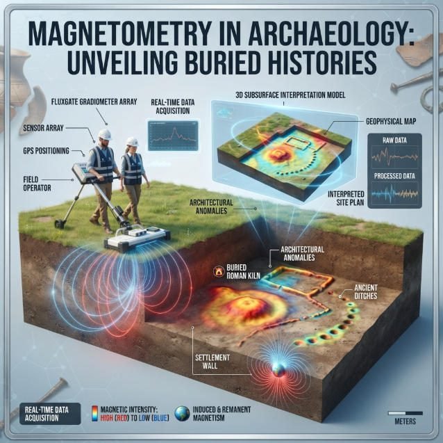
Overview:Archaeomagnetism maps subsurface magnetic signatures to detect buried archaeological features and historical remains. Archaeomagnetism case studies across Roman villa, Bronze Age palace and battlefield sites prove the value of magnetic survey. This guide covers field methods, data interpretation and best practices for archaeological magnetic survey applications.
Ⅰ. Introduction to Archaeomagnetism
1. Core Definition
Archaeomagnetism is a non-invasive geophysical technique that detects and maps buried archaeological features by measuring spatial variations in the Earth’s magnetic field caused by subsurface material properties.
It relies on contrasts in magnetic susceptibility and remanent magnetization between archaeological features and surrounding natural soil. Fired structures, ditches, pits and metal artifacts all produce measurable magnetic anomalies that can be detected from the surface.
Archaeological magnetic survey provides rapid, large-area coverage without excavation. It has become a standard tool for cultural resource management, site reconnaissance and targeted excavation planning.
2. Fundamental Physical Principles
All magnetic survey methods operate on the same core principle: subsurface materials distort the ambient geomagnetic field in predictable ways based on their magnetic properties.
Materials may exhibit induced magnetization, where they become temporarily magnetized by the Earth’s field, or remanent magnetization, where they retain permanent magnetism from past events. The combination creates a measurable local anomaly in the total magnetic field.
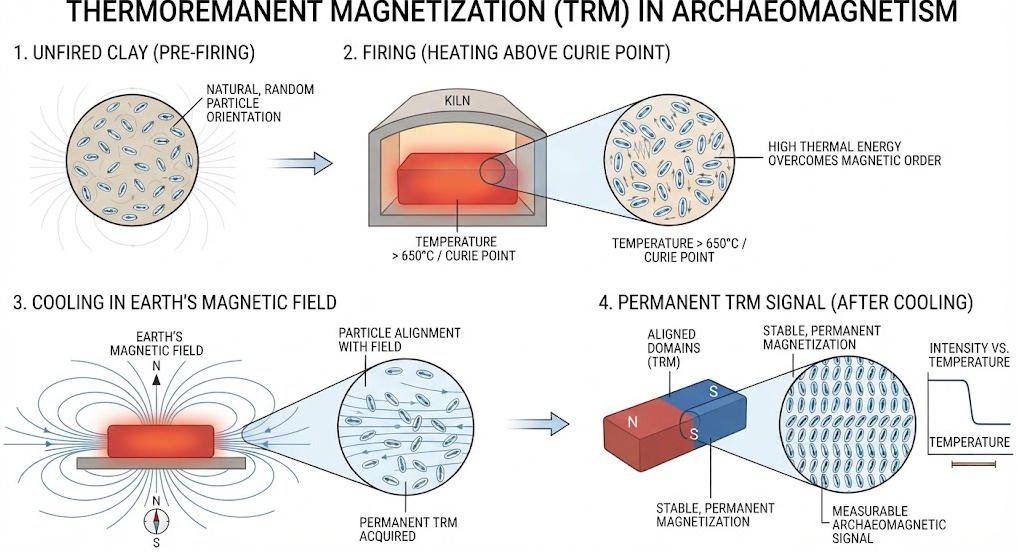
Fired clay materials such as bricks, pottery and hearths acquire strong thermoremanent magnetization (TRM) when they cool below the Curie point in the presence of the Earth’s magnetic field. This produces the strongest and most distinct archaeological magnetic signatures.
Ⅱ. Core Magnetic Survey Methods for Archaeology
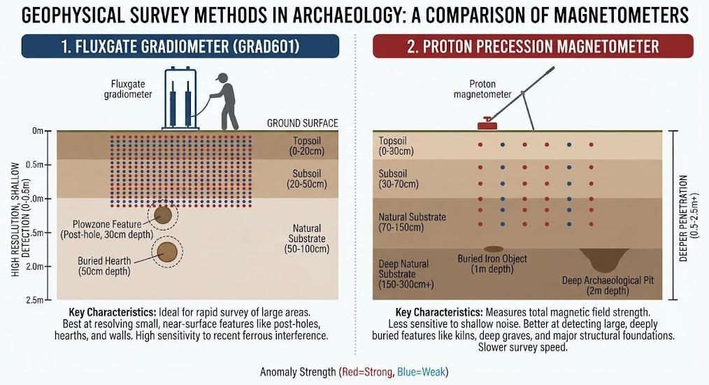
1. Primary Survey Techniques
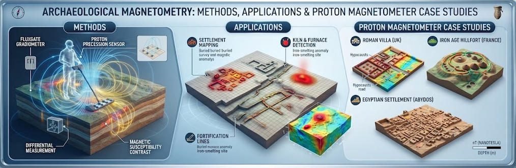
Archaeological magnetic surveys deploy two primary sensor types, each optimized for different target depths and feature scales.
Fluxgate gradiometers measure the gradient of the magnetic field using two closely spaced sensors. They cancel out the main geomagnetic field to emphasize local anomalies. Their high sampling density makes them ideal for detecting shallow, small-scale features such as pits, post holes and hearth features.
Proton precession magnetometers measure the absolute total magnetic field strength by observing the precession frequency of hydrogen protons in a polarized fluid. They offer greater depth penetration and detect larger, deeper features such as walls, ditches and large structural remains.
| Sensor Type | Measurement | Typical Depth Range | Optimal Targets | Sampling Density |
|---|---|---|---|---|
| Fluxgate gradiometer | Magnetic field gradient | 0–2 m | Pits, hearths, post holes, small artifacts | High (0.25–0.5 m grid) |
| Proton magnetometer | Total magnetic field | 0–5 m | Walls, ditches, foundations, large structures | Moderate (0.5–1 m grid) |
| Optical pumping magnetometer | Total magnetic field | 0–8 m | Deep structures, regional surveys | Low (1–2 m grid) |
2. Method Selection by Landscape Type
Magnetic survey performance varies significantly with site geology and soil conditions. Method selection must be adapted to individual site characteristics.
In well-drained mineral soils on chalk or limestone bedrock, magnetic surveys typically deliver excellent results. Clear contrasts between archaeological features and background soil produce sharp, interpretable anomalies.
In wetland and waterlogged soils, magnetic signals are muted and degraded. Survey teams use specialized sensors, tighter sampling grids or complementary methods such as ground penetrating radar to maintain detection capability.
In urban and industrial environments, modern cultural noise from pipes, power lines and metal debris presents major challenges. Survey design must include noise mitigation strategies and targeted validation.
3. Survey Deployment Workflow
Standard archaeological magnetic surveys follow a structured field workflow.
First, the survey area is laid out in a regular grid pattern marked by stakes and tapes. Grid dimensions are determined based on target size, required resolution and sensor type. Typical grid cells range from 20×20 m to 50×50 m.
Second, surveyors walk parallel traverses along the grid lines at constant speed while the instrument takes continuous readings. Traverse spacing matches the required sampling density, typically 0.5–1 m for standard site surveys.
Third, raw data is downloaded and processed in the field for initial quality control. Bad data points, drift effects and line mismatches are corrected before further processing.
Ⅲ. Global Case Studies in Archaeomagnetism
1. Roman Villa Reconstruction, Italy
In central Italy, a proton magnetometer survey of agricultural land revealed a complete 2,000-year-old Roman villa complex buried beneath ploughed fields.
The survey detected clear magnetic anomalies corresponding to wall foundations, a peristyle courtyard, thermal baths and storage buildings. Linear anomalies indicated boundary walls and field boundaries. Fired hearth and kiln features produced particularly strong magnetic signatures.
Targeted excavation following the survey uncovered mosaic floors, fresco fragments and olive oil amphorae, confirming the villa’s role as an agricultural and cultural hub. The magnetometer data achieved over 90% accuracy in predicting structural layout.
2. Bronze Age Palace Discovery, Greece
In southern Greece, magnetometer survey over a plowed field detected a large, regular magnetic anomaly pattern that did not match natural geological features.
Subsequent excavations revealed a Bronze Age palace with intact fresco fragments and Linear B tablet archives. The magnetic data had successfully mapped the palace’s outer walls, internal room divisions and gate structures.
The site provided new insights into Mycenaean governance, trade networks and social organization. It demonstrated how magnetic survey can identify major unknown sites in landscapes with little surface evidence.
3. Ancient Canal Systems, Egypt Nile Delta
In Egypt’s Nile Delta, magnetometer surveys detected extensive ancient canal networks buried beneath modern farmland.
These hydraulic systems, dating to the Pharaonic period, showed as linear magnetic anomalies from sediment infill differences. The surveys mapped hundreds of kilometers of ancient waterways without disturbing active agricultural land.
The findings reshaped understanding of ancient Egyptian water management, agricultural organization and settlement patterns. They demonstrated magnetic survey’s value for large-scale landscape archaeology.
4. Civil War Battlefield, United States
At a Civil War battlefield site in the US, high-resolution gradiometer surveys detected scattered magnetic anomalies from metal objects.
Systematic mapping identified bullet concentrations, cannonball impacts and trench lines. Analysis of anomaly distribution patterns reconstructed troop movements, battle strategies and encampment locations.
The project demonstrated how magnetic survey can reveal fine-grained details of historical events that leave little visible surface trace.
Case Study Summary Table
| Site | Location | Method | Key Findings | Detection Accuracy |
|---|---|---|---|---|
| Roman villa | Central Italy | Proton magnetometer | Complete villa complex with baths and courtyard | ~90% structural agreement |
| Bronze Age palace | Southern Greece | Fluxgate gradiometer | Palace walls, rooms and gate structures | Confirmed by excavation |
| Nile canals | Egyptian Delta | Proton magnetometer | Hundreds of km of ancient waterways | Matched sediment core evidence |
| Civil War battlefield | United States | High-resolution gradiometer | Bullets, cannonballs and trench lines | Identified individual artifacts |
Ⅳ. Historical Remains Detection Mechanism
1. Thermoremanent Magnetization (TRM)
Thermoremanent magnetization is the primary mechanism behind the strongest archaeological magnetic signatures.
When clay, brick or stone is heated above the Curie temperature (approximately 580°C for iron-bearing minerals), magnetic domains within the material become randomly oriented. As the material cools, the domains align with the Earth’s magnetic field at that time and lock in place.
This creates a permanent magnetic record of the ancient geomagnetic field. The resulting anomaly is typically much stronger than induced magnetization effects from normal soil materials.
TRM is responsible for the distinctive signatures of hearths, kilns, pottery kilns, fired brick structures and burning layers. These features are among the most reliably detected archaeological magnetic targets.
2. Magnetic Susceptibility Contrasts
Many archaeological features are detected through contrasts in magnetic susceptibility rather than remanent magnetization.
Ditches, pits and post holes filled with topsoil or humic sediment often have higher magnetic susceptibility than the surrounding subsoil. Organic decomposition and iron mineralization in fill materials create measurable susceptibility contrasts.
Stone foundations and bedrock features may produce negative anomalies where lower-susceptibility bedrock replaces more magnetic soil. The direction and shape of anomalies provide clues to feature type and orientation.
3. Artifact and Metal Detection
Metallic objects produce strong, characteristic magnetic dipole anomalies. Iron artifacts in particular create highly distinctive signatures that can be identified even at depth.
Individual nails, tools and weapons produce small, sharp anomalies. Larger objects such as cannons, anchors and structural iron produce broader, stronger signatures.
Metal detection capability makes magnetic survey valuable for battlefield archaeology, industrial heritage sites and shipwreck investigations.
Ⅴ. Archaeological Magnetic Data Interpretation Workflow
1. Data Processing and Image Generation
Raw magnetic survey data requires systematic processing before archaeological interpretation.
Processing steps include data gridding, noise removal, destriping to correct for line drift, and interpolation to create regular data grids. Advanced processing may include reduction to pole, analytic signal and gradient calculation to enhance feature definition.
Software packages such as Geoplot and ArchaeoSurvey process raw field data into contour maps, false-color images and 3D anomaly clusters. These visualizations make spatial patterns readily interpretable.
The goal of processing is to enhance genuine archaeological anomalies while suppressing geological noise and cultural interference.
2. Anomaly Classification and Interpretation
Interpretation involves classifying anomalies by shape, size, intensity and spatial pattern to infer archaeological feature type.
Linear anomalies typically represent walls, ditches, roads and boundaries. Rectilinear and curvilinear patterns indicate structural layouts and enclosures. Circular and ovoid anomalies may represent pits, hearths, kilns or barrows.
Interpreters assess anomaly depth using gradient analysis and signal width estimates. Deeper features produce broader, lower-amplitude anomalies with less sharp definition.
All interpretations consider the local archaeological context. Known site types, chronological periods and regional building traditions provide frameworks for evaluating anomaly significance.
3. Integration with Supporting Evidence
Magnetic data interpretation is strongest when integrated with other lines of evidence.
Historical records, aerial photography and LiDAR data provide landscape context and help identify expected feature types. Stratigraphic evidence from test pits calibrates anomaly signatures to actual archaeological deposits.
Complementary geophysical methods such as GPR and ERT provide additional property data. GPR adds high-resolution structural detail, while ERT reveals moisture and sediment contrasts that help distinguish feature types.
At a Maya site in Guatemala, magnetic anomalies were cross-referenced with LiDAR data to reveal a complex pyramid plaza hidden beneath dense jungle. This multi-method approach confirmed the site’s role as a regional political center.
Ⅵ. Best Practices and Common Pitfalls
1. Recommended Best Practices
Archaeological exploration best practices established through decades of case studies maximize survey effectiveness and reliability.
Collaboration: Partner with geophysicists, historians and local communities to contextualize findings. Local knowledge of landscape history and traditional place names often provides critical interpretive clues.
Iterative survey design: Use initial reconnaissance surveys to identify target zones, then deploy higher-resolution methods over priority areas. This staged approach balances coverage and detail while optimizing cost.
Public engagement: Share survey results with the public to raise awareness of cultural heritage. Community-led projects build local support for heritage protection and stewardship.
Ground truth verification: Always validate key anomalies with targeted test excavations or coring. No geophysical interpretation should be considered definitive without direct ground confirmation.
2. Common Pitfalls and Mitigation
Several recurring challenges affect archaeological magnetic survey quality and interpretation.
Noise interference: Modern infrastructure such as power lines, fences and buried pipes creates strong cultural noise. Mitigate by surveying during low-activity periods, using gradient sensors and mapping known noise sources.
Over-interpretation: Resist over-interpreting every small anomaly. Use multiple lines of evidence and test pit data to confirm feature interpretations. Geological features often produce patterns that mimic archaeological remains.
Data management issues: Store raw data and metadata meticulously for future reanalysis and replication. Standardized formatting enables comparison across sites and long-term monitoring projects.
Depth underestimation: Magnetic anomaly width increases with depth, and deep features appear broader and less defined. Use gradient methods or multiple sensor types to estimate depth more accurately.
Ⅶ. Equipment Selection for Archaeological Surveys
1. Proton Magnetometer Systems
Proton magnetometers are the workhorse instruments for medium-depth archaeological survey and large-area reconnaissance.
Key advantages include good depth penetration, absolute field measurement and relatively low cost. They effectively detect structural foundations, ditches, enclosure earthworks and large settlement features.
Modern systems offer built-in GPS, automated data logging and on-board processing. Lightweight portable models support all-day field surveys with minimal operator fatigue.
2. Fluxgate Gradiometer Systems
Fluxgate gradiometers provide the highest resolution for shallow, high-detail archaeological surveys.
Their high sampling density reveals small features such as post holes, hearth boundaries and individual artifact concentrations. Dual-sensor gradiometer configurations cancel diurnal drift and regional field variations.
High-end systems support walking speeds up to 5 km/h with continuous sampling, enabling efficient coverage of large survey areas at fine resolution.
3. Selection Criteria
Equipment selection depends on project objectives, site conditions and budget.
For large-area reconnaissance and deep structural features, select proton precession magnetometers with GPS navigation. For detailed site investigation and small feature detection, choose high-resolution fluxgate gradiometers.
For challenging environments such as urban sites or mineral-rich geology, consider multi-method surveys combining magnetic, GPR and ERT techniques.
Always match sampling density to expected feature size. The general rule is that traverse spacing should be no larger than half the minimum target dimension for reliable detection.
Related Articles
| Anchor Text | Suggested Internal Page |
|---|---|
| Proton Magnetometer | https://geotechcn.net/service/proton-precession-magnetometer/ |
| How Proton Precession Works | https://geotechcn.net/service/how-proton-precession-works-in-measurement/ |
| Proton Magnetometer Insights | https://geotechcn.net/service/proton-magnetometer-insights/ |
| Proton Magnetometer Signal | https://geotechcn.net/service/modulation-of-a-proton-magnetometer-signal-due-to-rotation/ |
| Dual-Sensor Proton Magnetometer | https://geotechcn.net/products/magnetic-instrument/dual-sensor-proton-magnetometer/ |
| Magnetic Exploration Instruments | https://geotechcn.net/products/magnetic-instrument/ |
| Future Directions of Geomagnetic Survey Equipment | https://geotechcn.net/service/future-directions-of-geomagnetic-survey-equipment/ |
| Geophysical Surveying | https://geotechcn.net/service/geophysical-surveying-explained/ |
Reference Sources
| Authority Source | Relevance to the Article | Hyperlink |
|---|---|---|
| Historic England – Geophysical Techniques | Covers archaeological magnetometry, fluxgate gradiometers, cesium magnetometers, magnetic anomalies, and the detection of buried archaeological features. | Historic England – Geophysical Techniques |
| Historic England – Geophysical Survey Advice | Provides professional guidance on selecting and applying geophysical methods for archaeological investigations. | Historic England – Geophysical Survey Advice |
| Historic England – Geophysical Survey | Explains how magnetometry, earth resistance, GPR, and other non-destructive methods are used to investigate buried remains. | Historic England – Geophysical Survey |
| EAC Guidelines for the Use of Geophysics in Archaeology | Provides guidance on survey design, fieldwork, data processing, interpretation, reporting, archiving, and method selection. | EAC Guidelines for the Use of Geophysics in Archaeology |
| Historic England – Low Ham Roman Villa | A real-world case involving vehicle-towed cesium magnetometry and GPR for investigating a Roman villa complex. | Low Ham Roman Villa Geophysical Survey |
| Historic England – Northbrook Farm / Shapwick Roman Villa | Demonstrates how magnetometer surveys can identify ditches, boundaries, and other archaeological features at Roman sites. | Northbrook Farm / Shapwick Roman Villa Survey |
| Historic England – Charlton Barrow Cemetery and Roman Villa | Provides a case study of Bronze Age barrows and a Roman villa investigated using vehicle-towed cesium magnetometry. | Charlton Barrow Cemetery and Roman Villa Survey |
| Historic England – Stonesfield Roman Villa | Shows how large-area cesium magnetometry can be combined with earth resistance and GPR to investigate buried Roman structures. | Stonesfield Roman Villa Geophysical Survey |
| Archaeology Data Service – Venta Icenorum Magnetic Survey | Provides an archaeological magnetometry research example using cesium-vapour magnetometers and GPS-based survey methods. | Venta Icenorum Magnetic Survey – Archaeology Data Service |
FAQ
Q1. What is archaeological magnetometry?
Archaeological magnetometry is a non-invasive geophysical method that measures variations in the Earth’s magnetic field to identify buried archaeological features. It can detect magnetic contrasts associated with kilns, hearths, furnaces, ditches, pits, burned structures and some buried walls.
Q2. What can an archaeological magnetometer detect?
An archaeological magnetometer can detect magnetic anomalies associated with fired materials, burned structures, ditches, pits, metal objects, some masonry and other buried features. Detection depends on the magnetic contrast between the archaeological feature and surrounding soil.
Q3. What is a proton magnetometer used for in archaeology?
A proton magnetometer measures the total intensity of the Earth’s magnetic field. It can be used for magnetic-field mapping, reconnaissance, anomaly investigation and selected archaeological or heritage surveys where total-field measurements are appropriate.
Q4. Is a proton magnetometer better than a fluxgate gradiometer for archaeology?
They measure magnetic information differently. Proton magnetometers measure total magnetic-field intensity, while fluxgate gradiometers are designed to measure magnetic gradients and are widely used for archaeological mapping. The appropriate instrument depends on survey objectives, target characteristics, site conditions and required spatial resolution.
Q5. Can magnetometry find Roman villas?
Yes. Archaeological magnetometry has been used to map Roman villa buildings, enclosures, ditches and associated landscape features. Historic England surveys at Low Ham, Stonesfield and other Roman sites have demonstrated this application.