Welcome to Geotech!

Comparative Study of Geophysical Exploration Methods: High-Density Electrical Resistivity, DC Resistivity Sounding, and Electrical Resistivity Tomography
1. Introduction
Geophysical exploration methods play a critical role in subsurface investigations. Among them, resistivity-based techniques are widely used due to their high sensitivity to electrical property variations. This article systematically compares four core resistivity methods: High-Density Resistivity (HDR), DC Resistivity Sounding, 2D & 3D Electrical Resistivity Imaging, and Electrical Resistivity Tomography (ERT), covering principles, advantages/disadvantages, applications, and data processing approaches.
2. Method Definitions and Principles
2.1 DC Resistivity Sounding
Definition: A technique using fixed electrode arrays to measure apparent resistivity variations with depth, constructing vertical electrical profiles.
Principle: Utilizes Wenner or Schlumberger configurations; increasing electrode spacing enhances penetration depth, ideal for layered stratigraphy analysis.
Technical Details:
- Electrode Configurations:
- Wenner Array: Four equally spaced electrodes (AMNB), ideal for homogeneous media.
- Schlumberger Array: Fixed inner potential electrodes with expanding current electrodes, suitable for deep surveys.
- Formula: Apparent resistivity ρa=k⋅ΔV/I, where k is the geometric factor.
2.2 High-Density Resistivity (HDR)
Definition: A multi-channel automated system for dense electrode array measurements, generating high-resolution 2D resistivity profiles.
Principle: Employs configurations like Wenner-alpha and Dipole-Dipole for rapid data acquisition and real-time imaging.
Technical Details:
- Data Acquisition Workflow:
- Electrode deployment (e.g., 64 channels, 5m spacing).
- Automated switching of current-potential pairs.
- Real-time apparent resistivity pseudo-section display.
- Case Study: In Xiong’an New Area, Wenner-alpha configuration (Figure 1) and resistivity depth slices (Figure 2) revealed interconnected sand lenses.
2.3 2D/3D Electrical Resistivity Imaging
Definition: Linear (2D) or grid-based (3D) electrode deployment to map spatial resistivity distributions.
Principle: Integrates forward modeling and inversion algorithms (e.g., least squares) to reconstruct subsurface electrical models.
Technical Details:
- 2D vs. 3D:
- 2D: Assumes no lateral variations, fast inversion.
- 3D: Requires grid arrays (e.g., 10×10), higher resolution but computationally intensive.
- Software:
- RES2DINV (2D): Smoothness-constrained inversion, ~5 min runtime.
- TOMO3D (3D): GPU-accelerated, >2 hours runtime, 40% resolution improvement.
2.4 Electrical Resistivity Tomography (ERT)
Definition (ERT): Combines cross-hole or surface-to-borehole electrodes for high-resolution 3D resistivity tomography.
Principle: Uses current injection and potential measurements with iterative inversion to optimize model accuracy, suitable for complex geological structures.
Technical Details:
- Cross-Hole ERT:
- Electrodes in boreholes (1-5m spacing) for inter-well imaging.
- Case Study: 3D ERT inversion mapped landfill leakage pathways (Figure 16).
- Surface-to-Borehole ERT:
- Combines surface and borehole electrodes for extended coverage.
3. Comparative Analysis
| ParameterDC Resistivity SoundingHDR2D Imaging3D ERT | ||||
|---|---|---|---|---|
| Resolution | Low (vertical) | Medium-High (2D profile) | High (2D profile) | Very High (3D volume) |
| Depth Range | 50-200 m | 10-100 m | 5-50 m | 5-150 m |
| Data Density | Sparse | Dense | Dense | Ultra-Dense |
| Efficiency | Low (manual adjustments) | High (automated) | Medium-High | Low (complex setup) |
| Cost | Low | Medium | Medium-High | High |
| Noise Immunity | Weak | Medium | Medium-High | High (multi-path data) |
| Typical Applications | Bedrock mapping | Urban engineering surveys | Fault detection | Mine leakage monitoring |
4. Advantages, Limitations & Applications
4.1 DC Resistivity Sounding
- Advantages: Simple operation, low cost, suitable for preliminary surveys.
- Limitations: Low resolution, unable to detect lateral variations.
- Applications: Bedrock depth mapping, regional groundwater surveys.
Case Expansion:
- Bedrock Depth in Hangzhou: DC sounding combined with borehole data reduced bedrock mapping errors to <5%.
- Aquifer Identification: Vertical resistivity gradients delineated aquifer-confining layer interfaces.
4.2 High-Density Resistivity (HDR)
- Advantages: High efficiency, dense data coverage, real-time imaging.
- Limitations: Shallow depth limitation (<100 m), affected by surface coupling.
- Applications: Engineering geology, pipeline detection, karst identification.
Case Expansion:
- Xiong’an Sand Lenses: 13 E-W and 8 N-S lines with Res2Dinv inversion revealed paleochannel networks.
- Urban Pipeline Detection: Combined HDR and full-polarization GPR resolved cast iron pipeline interference.
4.3 2D Electrical Resistivity Imaging
- Advantages: Balanced resolution and efficiency, ideal for linear targets.
- Limitations: Ignores 3D anomaly effects.
- Applications: Active fault detection, contaminant plume tracking.
Case Expansion:
- Jinan Baotu Spring: 2D imaging with surface wave analysis mapped groundwater channels for metro construction.
- Ground Fissures: Reflection tomography located near-surface fissures in Xi’an.
4.4 3D ERT
- Advantages: Full 3D spatial imaging, resolves complex structures.
- Limitations: High cost, complex data processing.
- Applications: Mine leakage monitoring, 3D archaeological site modeling.
Case Expansion:
- Landfill Leakage: Cross-hole ERT with fluid conductivity monitoring guided remediation.
- Archaeological Site: Surface ERT imaged Roman-era structures at 0.5m resolution.
5. Forward & Inverse Modeling
5.1 Forward Modeling
- Purpose: Generate theoretical responses based on assumed models.
- Methods: Finite Element Method (FEM), Finite Difference Method (FDM).
- Tools:
- RES2DMOD (2D HDR): Rapid layered model simulation.
- COMSOL (3D ERT): Complex geometry and anisotropy support.
5.2 Inverse Modeling
- Objective: Derive optimal resistivity models from field data.
- Methods:
- Smoothness-Constrained Inversion (Occam’s algorithm): For HDR/2D imaging.
- Structure-Coupled Inversion (L1-norm regularization): Enhances ERT edge detection.
6. Future Trends & Challenges
- AI-Driven Inversion: CNN-based ERT inversion reduces runtime by 70%.
- Multi-Method Fusion: Joint ERT-seismic inversion in Xiong’an multi-parameter models.
- Hardware Innovations: Distributed Acoustic Sensing (DAS) for urban adaptability.
7. Conclusion
HDR and 2D imaging offer cost-effective solutions for shallow engineering surveys, while 3D ERT excels in complex environments with its 3D capabilities. Future advancements require optimized inversion algorithms and hardware integration to meet urban subsurface precision demands.
8. Applications
Technical Principles and Equipment Selection
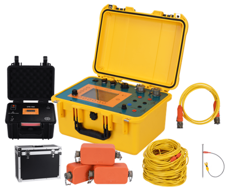
The GIM Series High-Density Electrical Resistivity System, independently developed by Geotech Technology, integrates DC resistivity and induced polarization (IP) dual-mode measurement technologies. With 12 electrode configurations (Wenner, Schlumberger, Dipole-Dipole, etc.), it supports 1D/2D/3D/4D full-dimensional exploration. The flagship GIM-10 system achieves industry-leading measurement accuracy of 0.3%±1μA/μV through its 24-bit A/D conversion and ±48V wide voltage range, making it ideal for deep subsurface investigations in complex terrains.
Breakthrough Technological Designs
- Intelligent Expansion System: Enables unlimited survey line extensions via bidirectional cascade controllers, coupled with patented distributed wiring technology, supporting multi-scenario detection (ground/cross-hole/borehole-surface/underwater).
- Military-Grade Reliability: IP67 waterproof housing and titanium alloy electrodes ensure stable operation in extreme environments (-20°C to 60°C), with underwater detection depths up to 100 meters.
- High-Efficiency Acquisition: 12-channel synchronous data collection improves field efficiency by 50%, capturing multi-electrode array data in a single transmission cycle.
Typical Application Scenarios
Geotech Solutions have been successfully deployed in 300+ global projects across diverse fields:
| Application Field | Typical Case | Technical Configuration |
|---|---|---|
| Mineral Exploration | 3D modeling of copper deposits | GIM-10 System + 3200W High-Voltage Transmitter Module (1500m penetration depth) |
| Geohazard Prevention | Dam integrity assessment | Rolling measurement technology + Custom 5m cable spacing solution |
| Environmental Monitoring | Landfill contamination tracking | IP-optimized cables + Real-time waveform monitoring software |
Engineering Case Studies
Case 1: Groundwater Contamination Assessment in Abandoned Mines
Client Needs: Rapid delineation of groundwater contamination boundaries in a lead-zinc mining area.
Geotech Solution:
- Conducted 3D resistivity imaging using the GIM-10 system with Schlumberger array.
- Deployed the SPB900 Intelligent Power Supply (850Wh Li-ion battery) for 72-hour continuous operation.
- Identified contaminant plumes through 20-time window IP analysis.
Outcome: Accurately mapped 2.3 km² of contaminated zones, reducing remediation costs by 40%.
Case 2: Submarine Sediment Thickness Survey
Technical Challenge: Severe signal attenuation due to seawater conductivity.
Innovative Approach:
- Custom 10m-spacing TPU waterproof cables.
- Dual-polarity pulse transmission mode (64s pulse width).
- Data inversion via Geotech’s proprietary AquaSurvey software.
Result: Successfully reconstructed 3D sediment layer structures across 5 km² in the South China Sea.