Welcome to Geotech!
-1.png)


Multi – Sensor Fusion in Electromagnetic Survey: Enhancing Precision and Expanding Capabilities
TIPS:Multi – sensor fusion in electromagnetic survey boosts precision via sensor data integration. It expands measurement capabilities, with applications in various scenarios. Discover how it enhances EM survey accuracy and functionality.
Ⅰ. Introduction to Electromagnetic Survey and Multi – Sensor Fusion
Electromagnetic (EM) survey is a crucial technique in various fields such as geophysical exploration, environmental monitoring, and industrial inspection. It involves measuring the electromagnetic fields to gather information about subsurface structures or material properties. In recent years, multi – sensor fusion has emerged as a game – changing technology in electromagnetic surveys.
Multi – sensor fusion in electromagnetic survey, also known as combining sensors for EM exploration, refers to the integration of data from multiple types of sensors. These sensors can include magnetometers, electromagnetic receivers, and even sensors for measuring related physical quantities like temperature and humidity in some cases. The goal is to leverage the complementary information from different sensors to improve the overall performance of the survey.
Ⅱ. Sensor Data Integration: The Foundation of Multi – Sensor Fusion
2.1 Integrating Data from Multiple Sensors
Sensor data integration is the core of multi – sensor fusion. In an electromagnetic survey, different sensors collect diverse types of data. For example, a magnetometer measures the magnetic field components, while an electromagnetic receiver detects the electric field variations. Integrating data from multiple sensors means combining these different data streams into a unified dataset.
This process is not just about simple data concatenation. It involves advanced data processing techniques to ensure that the data from different sensors are aligned in time and space. For instance, if one sensor has a higher sampling rate than another, interpolation or resampling techniques may be used to make the data compatible. Merging sensor information in this way allows for a more comprehensive understanding of the electromagnetic environment being surveyed.
2.2 Merging Sensor Information for Better Insight
Merging sensor information goes beyond just data integration. It involves analyzing the combined data to extract more meaningful insights. In geophysical exploration, for example, by merging data from a magnetometer (measuring magnetic fields) and an electromagnetic induction sensor (measuring conductivity), geoscientists can better distinguish between different types of geological structures.
The merged data can reveal patterns that would be hidden if only a single sensor’s data were analyzed. For instance, a certain geological formation might have a unique signature in the combined magnetic and electrical field data that is not apparent in either data set alone. This enhanced insight is invaluable for accurate subsurface mapping and resource exploration.
Ⅲ. Improving Measurement Accuracy with Multi – Sensor Fusion
3.1 Enhancing Accuracy Through Sensor Fusion
One of the primary benefits of multi – sensor fusion in electromagnetic survey is improved measurement accuracy. Each sensor has its own strengths and limitations. By fusing data from multiple sensors, we can compensate for the weaknesses of individual sensors.
For example, a single electromagnetic sensor might be affected by environmental noise, leading to inaccurate measurements. However, when combined with a sensor that is less sensitive to that particular type of noise (such as a magnetometer in some cases), the overall accuracy can be enhanced. Better precision with multiple sensors is achieved by using the complementary nature of different sensors to cross – validate and correct the data.
3.2 Reducing Uncertainty in Electromagnetic Surveys
Uncertainty is a major challenge in electromagnetic surveys. Factors such as soil conductivity variations, atmospheric interference, and instrument noise can all contribute to measurement uncertainty. Multi – sensor fusion helps in reducing this uncertainty.
By using multiple sensors, we can obtain redundant information about the electromagnetic field. For example, if two different sensors measure the same electromagnetic quantity but are affected by different noise sources, the fused data can have a lower uncertainty. This is because the noise components that affect one sensor may not affect the other, and through proper data fusion algorithms, the overall uncertainty in the measurement can be reduced.
Ⅳ. Expanded Measurement Capabilities with Multi – Sensor Fusion
4.1 Broadening Measurement Scope
Multi – sensor fusion broadens the measurement scope of electromagnetic surveys. A single sensor is limited in the range of phenomena it can detect. By integrating multiple sensors, we can expand the types of information we can gather.
In environmental monitoring, for example, an electromagnetic survey might involve sensors for measuring electromagnetic fields, as well as sensors for measuring soil moisture and temperature. By fusing these data, we can not only understand the electromagnetic environment but also how it relates to other environmental factors. This expanded measurement scope allows for a more holistic assessment of the surveyed area.
4.2 Wider Functionality with Multi – Sensors
Wider functionality with multi – sensors is another advantage of multi – sensor fusion. In industrial inspection, for instance, electromagnetic surveys can be used to detect defects in metal structures. By fusing data from electromagnetic sensors with acoustic sensors (for detecting mechanical defects) and visual sensors (for surface inspection), a more comprehensive inspection can be carried out.
This wider functionality enables the detection of a broader range of issues in a single survey. Instead of conducting separate surveys with different sensors, multi – sensor fusion allows for a more efficient and comprehensive inspection process, saving time and resources.
Ⅴ. Applications of Multi – Sensor Systems in Electromagnetic Surveys
5.1 Uses of Multi – Sensor Setups
Multi – sensor systems have a wide range of uses in electromagnetic surveys. In geophysical exploration, they are used to map subsurface mineral deposits, oil and gas reservoirs, and geological structures. By combining data from magnetometers, electromagnetic receivers, and gravity sensors (in some cases), geoscientists can get a more complete picture of the subsurface.
In environmental monitoring, multi – sensor setups are used to study the impact of human activities on the electromagnetic environment. For example, near power plants or communication towers, multi – sensor systems can detect changes in the electromagnetic field, as well as related factors like air quality and noise levels.
5.2 Scenarios for Sensor Fusion
There are various scenarios for sensor fusion in electromagnetic surveys. In marine electromagnetic surveys, for example, sensors are deployed on the sea floor, on surface vessels, and even on airborne platforms. Fusing data from these different platforms allows for a comprehensive study of the marine electromagnetic environment, which is important for understanding processes like seafloor spreading and hydrocarbon exploration.
In land – based surveys, sensor fusion can be used in urban areas for infrastructure inspection. By fusing data from electromagnetic sensors with other non – destructive testing sensors, engineers can detect hidden defects in buildings, bridges, and pipelines without causing damage to the structures.
Ⅵ. Challenges in Multi – Sensor Fusion for Electromagnetic Surveys
6.1 Data Compatibility and Calibration
One of the main challenges in multi – sensor fusion is data compatibility. Different sensors may have different measurement units, sampling rates, and accuracy levels. Ensuring that these data can be merged effectively requires careful calibration and data transformation.
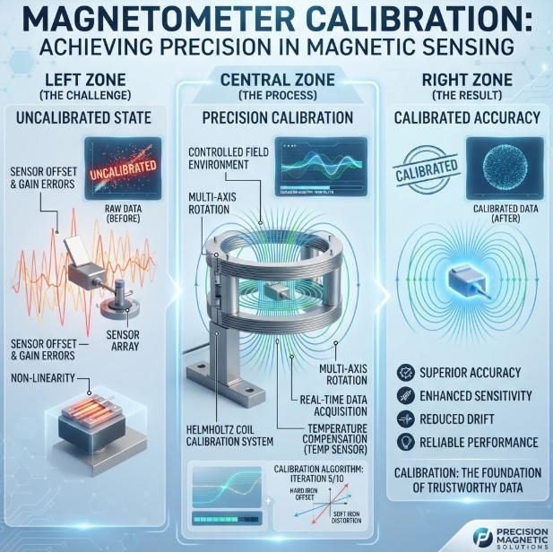
Calibration of each sensor is essential to ensure that their measurements are accurate and comparable. For example, a magnetometer and an electromagnetic receiver need to be calibrated to the same reference frame so that their data can be meaningfully fused. In addition, data transformation techniques may be needed to convert data from different sensors into a common format.
6.2 Algorithm Development for Fusion
Developing effective fusion algorithms is another challenge. The fusion of data from multiple sensors is not a trivial task. It requires algorithms that can handle different types of data, account for noise and uncertainty, and extract meaningful information from the combined dataset.
These algorithms need to be tailored to the specific requirements of electromagnetic surveys. For example, in a survey where the goal is to detect small changes in the electromagnetic field, the fusion algorithm needs to be sensitive enough to pick up these changes while filtering out noise. Developing such algorithms requires a deep understanding of both electromagnetic theory and data fusion techniques.
Ⅶ. Future Trends in Multi – Sensor Fusion for Electromagnetic Surveys
7.1 Advancements in Sensor Technology
The future of multi – sensor fusion in electromagnetic surveys lies in advancements in sensor technology. New sensors are being developed with higher sensitivity, lower power consumption, and smaller form factors. These sensors will enable more comprehensive multi – sensor setups, as they can be easily deployed in various environments.
For example, the development of micro – electromechanical systems (MEMS) sensors has led to the creation of small, low – cost electromagnetic sensors. These sensors can be integrated into multi – sensor systems more easily, allowing for more widespread use of multi – sensor fusion in electromagnetic surveys.
7.2 Artificial Intelligence in Sensor Fusion
Artificial intelligence (AI) is set to play a major role in future multi – sensor fusion. AI algorithms, such as machine learning and deep learning, can be used to automatically analyze and fuse data from multiple sensors. These algorithms can learn the patterns and relationships in the data, making the fusion process more efficient and accurate.
In electromagnetic surveys, AI – based fusion algorithms can be used to detect complex patterns in the electromagnetic field data that would be difficult for human analysts to identify. For example, machine learning algorithms can be trained to recognize the electromagnetic signatures of different geological structures or environmental hazards, enabling more accurate and automated survey interpretation.
Reference
- WIKI:https://en.wikipedia.org/wiki/Electrical_resistivity_tomography
- Society of Exploration Geophysicists (SEG) https://seg.org/
- Society of Environmental and Engineering Geophysicists (EEGS) https://www.eegs.org/
- Geology and Equipment Branch of China Mining Association http://www.chinamining.org.cn/
- International Union of Geological Sciences (IUGS) http://www.iugs.org/
- European Geological Survey Union (Eurogeosurveys) https://www.eurogeosurveys.org/