Welcome to Geotech!

What is soil resistivity test method?
I. Introduction
Soil Resistivity Test (SRT) is a geophysical technique used to measure the electrical resistivity of soil. This method helps assess soil corrosivity, design grounding systems, and optimize infrastructure. This article explores the principles, methods, applications, and comparisons of soil resistivity testing, providing a comprehensive reference for professionals and decision-makers.
II. Definition and Principle of Soil Resistivity Test
Soil resistivity testing is based on Ohm’s Law. It involves inserting electrodes into the soil and measuring the voltage drop to calculate the soil’s resistivity. High resistivity soils are generally less corrosive than low resistivity soils。
III. Key Methods of Soil Resistivity Test
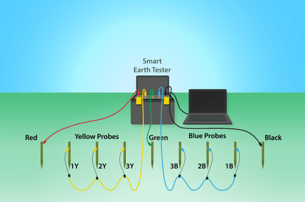
(1) Wenner Four-Probe Method
The Wenner method requires four electrodes to be placed at equal distances in a straight line. Voltage is applied between the outer electrodes, and the voltage drop between the inner electrodes is measured to calculate soil resistivity。
(2) Schlumberger Method
Similar to the Wenner method, the Schlumberger method allows for unequal electrode spacing, making it suitable for geological surveys requiring measurements at different depths。
IV. Applications of Soil Resistivity Test
Soil resistivity testing is extensively used in the following fields:
- Corrosion Protection: Assessing the corrosivity of underground structures and designing cathodic protection systems.
- Grounding System Design: Optimizing grounding systems for telecommunications towers and substations to ensure safety.
- Geological Surveys: Identifying geological features such as ore locations and bedrock depth.
- Environmental Monitoring: Evaluating soil corrosivity to support environmental protection measures.
V. Comparison with Other Methods
(1) Comparison with Ground-Penetrating Radar
- Advantages: GPR offers high resolution for shallow geological exploration and rapid data acquisition.
- Limitations: Limited application in deep exploration and complex geological conditions, and relatively high cost.
- Best Application Scenarios: Suitable for detecting shallow aquifers, underground voids, and fractures.
(2) Comparison with Traditional Drilling Methods
- Advantages: Soil resistivity testing is non-destructive, cost-effective, and can quickly acquire extensive geological information.
- Limitations: Data interpretation requires professional knowledge and may be affected by external electromagnetic noise.
- Best Application Scenarios: Ideal for corrosion protection, grounding system design, and geological surveys.
VI. Advantages and Limitations of Soil Resistivity Test
(1) Advantages
- Non-Destructive Testing: Does not damage the soil, making it an eco-friendly technique.
- High Precision: Provides detailed soil resistivity distribution information for precise corrosion risk assessment.
- Flexibility: Suitable for various geological conditions and environments.
- Cost-Effective: Lower usage costs compared to traditional drilling methods, with quick results.
(2) Limitations
- Data Interpretation Complexity: Requires professional knowledge for accurate interpretation, especially in complex geological conditions.
- External Interference: Susceptible to electromagnetic noise from external sources like power lines and communication cables.
- Depth Limitations: May not be sufficient for deep geological surveys in some cases.
VII. Case Studies
(1) Case Study 1: Corrosion Protection for Oil and Gas Pipelines
A major oil and gas company used the Wenner four-probe method to identify highly corrosive soil areas. Based on the data, a customized cathodic protection system was designed, significantly reducing corrosion rates and extending pipeline lifespan。
(2) Case Study 2: Grounding System Design for a Telecommunications Tower
A telecommunications company employed the Wenner method and Electrical Resistivity Imaging (ERI) to design a robust grounding system. The system effectively diverted fault currents, ensuring safety and compliance with standards。
VIII. Company Product Introduction
As a leading enterprise in geophysical exploration, we introduce the GIM Series, a multi-functional electrical exploration device. The GIM Series integrates natural potential measurement, 1D/2D/3D resistivity imaging (ERT), and induced polarization (IP), offering a comprehensive solution for soil resistivity testing。
(1) Product Features
- High-Precision Data Acquisition: 24-bit A/D conversion ensures accurate and reliable data.
- Depth Breakthrough: Bi-directional cascading technology achieves a detection depth of 1,500 meters.
- Strong Environmental Adaptability: IP67 waterproof design and a wide operating temperature range (-20°C to +60°C).
- Multi-Scenario Application: Suitable for various complex geological conditions and application scenarios.
- Efficient Data Collection: 10-channel synchronous acquisition + rolling measurement mode.
- Data Compatibility: Exports data in TXT/Excel formats compatible with mainstream inversion software.
(2) Success Cases
The GIM Series has excelled in numerous projects, assisting clients in efficiently measuring soil resistivity. For example, in an oil and gas pipeline project, the GIM Series provided critical data for cathodic protection system design. In a telecommunications tower project, it successfully optimized the grounding system design.
IX. Future Outlook
With continuous technological advancements, soil resistivity testing is set to embrace new opportunities in technology integration, intelligent development, environmental sustainability, and interdisciplinary collaboration.
X. Conclusion
Soil resistivity testing is a vital tool in modern geophysical exploration, playing an increasingly important role in the rational development and protection of underground resources. Through continuous innovation and practical applications, this technology will contribute significantly to addressing global resource challenges. Choosing our GIM Series is choosing a reliable partner for exploring underground resources with us.

