Welcome to Geotech!
-1.png)


What Is a Magnetometer and How Does It Work?丨Proton Magnetometer Guide
TIPS:A magnetometer measures magnetic field strength with remarkable precision. This guide explains what a magnetometer is and how a proton magnetometer uses quantum physics to detect subsurface anomalies. You will learn how this instrument works in mineral exploration, archaeology, and space missions. We compare fluxgate and proton technologies to help you select the right magnetic field measurement device.
Ⅰ. What Is a Magnetometer?
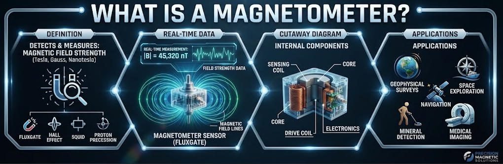
A magnetometer is a scientific instrument that measures magnetic field strength and direction. It detects the invisible forces that surround magnets, electric currents, and geological formations. Engineers, geophysicists, and space agencies rely on these devices daily.
1. The Basic Principle Behind Magnetic Measurement
Magnetic fields exist everywhere. Earth generates a global field that protects life from solar radiation. Rocks record ancient field directions. Ore bodies distort local fields. A magnetic sensor quantifies these effects.
The instrument converts magnetic forces into readable signals. Different technologies achieve this conversion. Some use quantum mechanical effects. Others rely on electromagnetic induction. All approaches share one goal: accurate magnetic field measurement.
2. Common Applications Across Industries
Geophysicists deploy magnetic sensors for mineral exploration. Iron ore deposits create strong anomalies. Survey teams map these features from the surface. They identify drilling targets without excavation.
Archaeologists use magnetic instruments to find buried structures. Fired clay becomes permanently magnetized. Foundation ditches fill with magnetic topsoil. These features create detectable signatures. Non-invasive surveys preserve heritage sites.
Space agencies mount magnetic sensors on satellites. They monitor solar wind interactions with planetary fields. Mars lost its magnetic shield billions of years ago. Instruments confirm this history. They guide future colonization plans.
Defense systems use magnetic sensors for submarine detection. Submarines distort Earth’s field as they move. Sensors track these distortions. Naval strategy depends on this capability.
3. Types of Magnetic Instruments
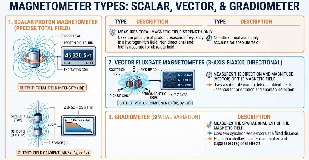
Three main categories dominate the market. Scalar instruments measure total field strength. Vector devices record direction and magnitude. Gradiometers measure spatial differences between two sensors.
Proton devices belong to the scalar family. They achieve exceptional absolute accuracy. Fluxgate units measure vector components. They suit navigation and orientation tasks. Optical pumping devices offer extreme sensitivity. They serve specialized scientific missions.
Ⅱ. How Does a Magnetometer Work?
Different magnetic sensor types use different physical principles. Understanding these mechanisms helps users select appropriate instruments.
1. Proton Precession Devices
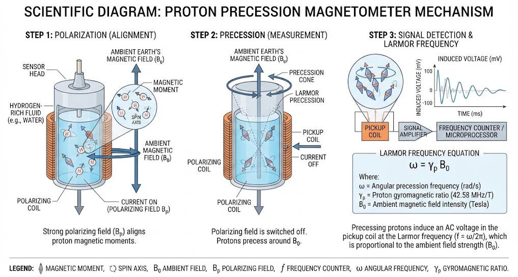
Proton instruments exploit a quantum property of hydrogen atoms. Protons possess magnetic moments. They behave like tiny compass needles. A polarizing current aligns these moments. After the current stops, protons precess around Earth’s magnetic field.
The precession frequency follows the Larmor equation. It equals approximately 42.58 hertz per nanotesla. A 50,000-nanotesla field produces about 2.13 megahertz. The instrument counts this frequency precisely. Stable oscillators ensure accurate timing.
This method delivers absolute measurements. It does not require calibration against external references. Results remain stable across wide temperature ranges. These advantages make proton devices popular for geophysical surveys.
2. Fluxgate Operation
Fluxgate units use ferromagnetic cores. An alternating current drives the core into saturation. External magnetic fields shift the saturation timing. Sensors detect this shift. Amplifiers convert it into voltage signals.
These instruments measure vector components. They record field strength along three orthogonal axes. Navigation systems use this directional information. Aircraft and spacecraft rely on fluxgate units for attitude control.
3. Optical Pumping Sensors
Optical pumping devices use alkali vapor cells. Laser light polarizes atomic spins. Magnetic fields alter the absorption spectrum. Photodetectors measure these changes. The technique achieves femtotesla sensitivity.
Such extreme sensitivity suits specialized applications. Brain imaging maps neural currents. Fundamental physics experiments test theoretical predictions. Space missions study weak planetary fields.
4. Gradiometers
Gradiometers use two sensors separated by a fixed distance. They measure field differences rather than absolute values. This approach cancels common noise sources. It enhances anomaly detection.
Geophysical surveys benefit significantly. Cultural noise from power lines affects both sensors equally. The difference signal removes this interference. Weak geological anomalies become visible.
Ⅲ. What Is a Proton Magnetometer?
A proton magnetometer represents the gold standard for field geophysics. It combines simplicity with extraordinary precision.
1. The Physics of Proton Precession
Hydrogen nuclei contain single protons. Each proton spins like a tiny top. This spin creates a magnetic moment. The moment aligns with applied magnetic fields.
A polarizing coil surrounds a fluid rich in hydrogen. The coil carries a strong direct current. This current generates a temporary magnetic field. Protons align with this field.
When the current switches off, protons return to equilibrium. They precess around Earth’s field at the Larmor frequency. The precession induces a weak alternating voltage in a pickup coil. Electronics amplify and count this signal.
2. Key Performance Specifications
Modern proton devices achieve 0.01-nanotesla resolution. Absolute accuracy reaches 0.1 nanotesla. These specifications exceed most geological requirements.
The measurement cycle takes one to four seconds. Polarization requires most of this time. Counting the precession frequency needs only a fraction. Rapid cycling enables dense survey coverage.
Gradient tolerance matters for practical use. Nearby magnetic sources distort measurements. Quality instruments tolerate gradients up to 5,000 nanotesla per meter. This capability allows close proximity to geological structures.
3. Field Deployment Considerations
Proton devices work in diverse environments. Temperature ranges from -40 to +55 degrees Celsius. Humidity reaches 95 percent. Rain and dust do not affect performance.
Portability varies by design. Some units fit in a backpack. Others require vehicle transport. Battery life ranges from 12 to 24 hours. Solar charging extends operations indefinitely.
GPS integration automates position recording. Each measurement links to precise coordinates. Post-processing software creates anomaly maps. These maps guide exploration decisions.
[插入图片4: proton-magnetometer-field-deployment-geotech.jpg]
Ⅳ. Applications in Geophysical Surveying
Magnetic surveys contribute to many exploration programs. This section covers primary applications.
1. Mineral Exploration
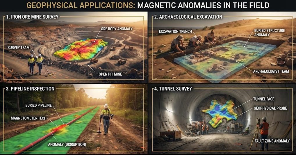
Iron ore deposits create the strongest anomalies. Magnetite alters local fields dramatically. Survey teams map these changes from aircraft or ground vehicles. They identify economic concentrations.
Base metal deposits also produce signatures. Pyrrhotite accompanies many lead-zinc systems. Nickel sulfides show distinct patterns. Magnetic sensors detect these associations. Geologists use them to prioritize targets.
2. Archaeological Prospection
Buried structures alter soil magnetism. Fired clay becomes permanently magnetized. Ditches and pits fill with topsoil. These changes create measurable contrasts.
High-resolution surveys reveal settlement patterns. Rectangular enclosures indicate Roman sites. Circular anomalies suggest prehistoric features. Magnetic instruments guide excavation without destructive testing.
3. Environmental Monitoring
Underground pipelines create linear anomalies. Steel distorts Earth’s field. Sensors trace pipeline routes. This information prevents accidental damage during construction.
Landfill monitoring tracks leachate migration. Contaminated water changes soil conductivity. Time-lapse surveys show plume movement. Regulators require such documentation.
4. Engineering Geology
Foundation studies need bedrock mapping. Weathered rock shows different magnetic properties than fresh rock. Sensors identify suitable bearing depths. Engineers design safer structures.
Tunnel projects use magnetic data. Fault zones display characteristic signatures. Advance knowledge improves safety. Magnetic surveys reduce geological surprises.
Ⅴ. Selecting the Right Instrument for Your Project
Instrument choice affects survey quality. Consider these factors carefully.
1. Define Measurement Requirements
Scalar measurements suffice for most geological tasks. Total field strength reveals anomaly locations. Vector data adds directional information. It suits navigation and orientation applications.
Resolution requirements depend on target size. Small ore bodies need 0.01-nanotesla sensitivity. Regional surveys tolerate 0.1 nanotesla. Match instrument specifications to project goals.
2. Evaluate Environmental Conditions
Temperature extremes affect some technologies. Proton devices handle wide ranges well. Fluxgate units may need compensation. Check specifications against field conditions.
Cultural noise complicates urban surveys. Power lines create strong interference. Gradiometers cancel this noise. They suit challenging electromagnetic environments.
3. Consider Portability and Logistics
Aerial surveys need lightweight instruments. Fixed-wing aircraft carry limited payloads. Helicopters offer more capacity. Drone-mounted systems expand possibilities.
Ground surveys balance weight against features. Backpack units suit rough terrain. Vehicle-mounted systems cover large areas faster. Choose configurations that match access limitations.
4. Budget for Total System Cost
Purchase price represents only part of the investment. Software licenses add expense. Training programs develop operator skills. Maintenance contracts ensure long-term reliability.
Consider data processing requirements. Some systems need specialized software. Cloud processing reduces local computing needs. Factor these costs into project budgets.
Ⅵ. The Future of Magnetic Sensing Technology
Innovation continues advancing magnetic sensing. Several trends shape future development.
1. Miniaturization and Integration
MEMS technology shrinks magnetic sensors. Smartphone magnetometers navigate daily life. Future geophysical instruments may approach similar sizes. Portability will improve dramatically.
Integration with other sensors accelerates. Combined magnetic and electromagnetic units gather diverse data. Single traverses collect multiple datasets. Survey efficiency increases.
2. Artificial Intelligence in Data Processing
Machine learning automates anomaly detection. Neural networks recognize feature patterns. They flag interesting zones for human review. Processing speed increases significantly.
AI also optimizes survey design. Algorithms predict optimal line spacing. They estimate detection probabilities. These tools improve planning efficiency.
3. Quantum Sensing Advances
Nitrogen-vacancy centers in diamond offer new possibilities. These quantum defects sense magnetic fields with extreme sensitivity. Room-temperature operation simplifies deployment.
Research prototypes demonstrate femtotesla sensitivity. Commercialization remains several years away. When available, these devices will transform weak-field measurements.
4. Real-Time Data Visualization
Field computers now display preliminary maps. Operators adjust surveys immediately. Quality control improves dramatically. Decision-making accelerates.
Cloud connectivity enables remote collaboration. Specialists review data from distant offices. Results reach clients faster. Project timelines compress.
Ⅶ. Conclusion
A magnetometer transforms invisible magnetic fields into measurable data. Proton devices deliver exceptional precision for geophysical surveys. Fluxgate units serve navigation and vector measurement needs. Gradiometers enhance anomaly detection in noisy environments.
Understanding how these instruments work helps professionals select appropriate tools. Project requirements, environmental conditions, and budget constraints all influence choice. Modern technology offers solutions for every application.
Geotech manufactures advanced proton magnetometers for field geophysics. Our instruments achieve 0.01-nanotesla resolution. They operate reliably from arctic tundra to tropical jungles. Contact our team to discuss your magnetic survey requirements.
Magnetic sensing technology continues evolving. Quantum advances promise even greater sensitivity. AI processing accelerates interpretation. These innovations will expand exploration capabilities for decades to come.
Reference Sources
| Related Websites | URL |
|---|---|
| USGS Geomagnetism Program | https://geomag.usgs.gov/ |
| INTERMAGNET Observatory Network | https://www.intermagnet.org/ |
| Society of Exploration Geophysicists (SEG) | https://seg.org/ |
| International Association of Geomagnetism and Aeronomy (IAGA) | https://www.iaga-aiga.org/ |
| NASA Heliophysics Science Division | https://science.nasa.gov/heliophysics/ |
| British Geological Survey – Geomagnetism | https://www.bgs.ac.uk/geology-projects/geomagnetism/ |
| NOAA National Centers for Environmental Information | https://www.ncei.noaa.gov/products/international-geomagnetic-reference-field |
Articles related to magnetometers and magnetic surveys:
- How Does a Magnetometer Work: https://geotechcn.net/service/how-does-a-magnetometer-work/
- Traditional vs Proton Magnetometers: https://geotechcn.net/service/traditional-vs-proton-magnetometers/
- Proton Precession Magnetometer: https://geotechcn.net/service/proton-precession-magnetometer/
- Magnetometer Types: https://geotechcn.net/service/magnetometer-types/
- Types & Selection of Geomagnetic Survey Equipment: https://geotechcn.net/service/types-selection-of-geomagnetic-survey-equipment/
- How Magnetometer Aids Mineral Exploration: https://geotechcn.net/service/how-magnetometer-aids-mineral-exploration/
- How Archaeological Magnetometry Detects Ancient Sites: https://geotechcn.net/service/how-archaeological-magnetometry-detects-ancient-sites/
- Studying Proton Magnetometer Stability & Reliability: https://geotechcn.net/service/studying-proton-magnetometer-stability-reliability/
- Magnetometer Calibration Process Importance: https://geotechcn.net/service/magnetometer-calibration-process-importance/
- Portable Magnetometer Design: https://geotechcn.net/service/portable-magnetometer-design-2/
- High Resolution Magnetometers: https://geotechcn.net/service/how-high-resolution-magnetometers-enhance/
- OCXO Technology: https://geotechcn.net/service/ocxo-technology/
- Magnetometry in Archaeology: https://geotechcn.net/service/magnetometry-in-archaeology/
FAQ
Q1: What is a magnetometer used for?
A1: A magnetometer measures magnetic field strength and direction. Geophysicists use it for mineral exploration, archaeological surveys, and environmental monitoring. Space agencies deploy it on satellites to study planetary fields. Defense systems use magnetic sensors for submarine detection.
Q2: How does a proton magnetometer work?
A2: A proton magnetometer uses the quantum property of hydrogen atoms. A polarizing current aligns proton magnetic moments. When the current stops, protons precess around Earth’s field at the Larmor frequency. The instrument counts this frequency to calculate absolute field strength with 0.01 nT resolution.
Q3: What is the difference between a fluxgate and proton magnetometer?
A3: A fluxgate magnetometer measures vector components using ferromagnetic cores. It suits navigation and attitude control. A proton magnetometer measures scalar total field strength using quantum precession. It delivers higher absolute accuracy for geophysical surveys.
Q4: What is magnetic anomaly detection?
A4: Magnetic anomaly detection identifies deviations from Earth’s normal magnetic field. Ore bodies, buried structures, and pipelines create measurable anomalies. Survey teams map these variations to locate targets without excavation.
Q5: How accurate is a proton magnetometer?
A5: Modern proton magnetometers achieve 0.01 nanotesla resolution and 0.1 nanotesla absolute accuracy. They tolerate temperature ranges from -40 to +55 degrees Celsius. These specifications exceed most geological exploration requirements.