Welcome to Geotech!
-1.png)


Airborne Electromagnetic Systems – State of the Art and Future Directions
TIPS:Airborne electromagnetics (AEM) stands as one of the most widely deployed geophysical methods in mineral exploration worldwide, second only to aeromagnetics-radiometrics. Initially developed post-WWII for mineral exploration, AEM has evolved from a simple “bump finding tool” into a deeply penetrating geologic mapper through continuous advances in acquisition systems, calibration, and data processing. Today, AEM extends beyond mineral exploration to groundwater, engineering, and hydrocarbon applications, with fierce competition among manufacturers driving rapid innovation in fixed-wing and particularly helicopter time-domain EM systems.

Ⅰ. State-of-the-Art Review of Airborne Electromagnetic Methods
Airborne electromagnetics (AEM) is one of the world’s most popular geophysical methods for mineral exploration, likely second only to aeromagnetics-radiometrics in global deployment. Initially developed post-World War II to find mineral deposits (Fountain, 1998), its primary use has long been searching for conductive massive sulphide ores.
Since then, constant improvements in systems, calibration, and data processing have transformed AEM. It has evolved from a simple “bump finder” into a sensitive, deep-penetrating geological mapper. Its applications have also broadened to include groundwater, engineering, and hydrocarbon exploration (Smith, 2010).
The significant investment in AEM and the fierce competition among service providers have driven nearly annual advancements, especially in helicopter time-domain electromagnetic (TDEM) systems, over the past decades. This has resulted in a large market with numerous AEM systems and providers.
In contrast, ground EM instrumentation has seen far fewer changes over comparable periods. This disparity is evident in review literature; for instance, Vallée et al.’s (2011) 20-page review dedicated 6 pages to airborne EM alone, but only 3.5 pages to all ground geophysical methods combined. Ultimately, the intense competition in AEM has greatly benefited the exploration industry through constant innovation, improved technology, and relatively stable costs per kilometer, ensuring AEM’s continued popularity.
A review of Killeen (2014) and Vallée et al. (2011) reveals a complex market with many AEM systems—some new, some old, some renamed, and some promising but discontinued. This paper focuses primarily on state-of-the-art, commercially available AEM systems from major service providers in Canada. For a comprehensive overview of the global evolution and variety of AEM systems, readers are referred to the reviews by Killeen (2014), Vallée et al. (2011), Allard (2007), and Sattel (2006).
Ⅱ. AEM System Basics (Simplified Version)
Electromagnetic methods measure electric (E) or magnetic (H) fields using EM receivers and transmitters (Swift, 1987). AEM systems are classified by:
1. Waveform: Frequency-domain (FEM) or time-domain (TEM).
2. Field Source:
- Active (controlled): Transmitter + receiver (TEM/FEM).
- Passive (natural): Only receiver (e.g., natural fields, VLF EM).
- Semi-airborne: Ground transmitter + airborne receiver (Fountain, 2008).
3. Platform: Fixed-wing (FTEM/FFEM) or helicopter (HTEM/HFEM), but systems can be deployed on either (Fountain, 2008). All systems measure induced primary + secondary magnetic fields (Fig. 1a).
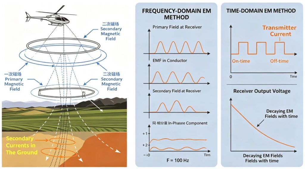
Figure 1. A) Schematic airborne EM system and induced vs. measured fields (after Viezzoli, 2014); B) Frequency-domain EM primary and secondary fields at receiver (after Klein and Lajoie, 1980); C) Time-domain EM transmitter and receiver waveforms (after US EPA Environmental Geophysics website).
EM measurements involve a primary field from the transmitter and a secondary field from the geology. Frequency-domain EM (FEM) systems transmit sinusoidal waves at multiple frequencies and isolate the secondary field by subtracting predicted from measured fields, yielding In-phase (IP) and Quadrature (QD) components; bedrock conductivity is inferred from the IP/QD ratio across frequencies. Time-domain EM (TEM) systems measure only the secondary field during transmitter-off periods, recording its decay over time; conductivity-depth profiles are derived from decay amplitudes and rates. Passive AEM systems use field ratios or base-station receivers to separate time-varying horizontal primary fields from vertical secondary fields, also outputting IP and QD data. All three methods measure 2–3 components (Z=vertical, X=in-line horizontal, and sometimes Y=cross-line horizontal). EM modeling and inversion are standard tools for extracting conductivity/resistivity from these measurements.
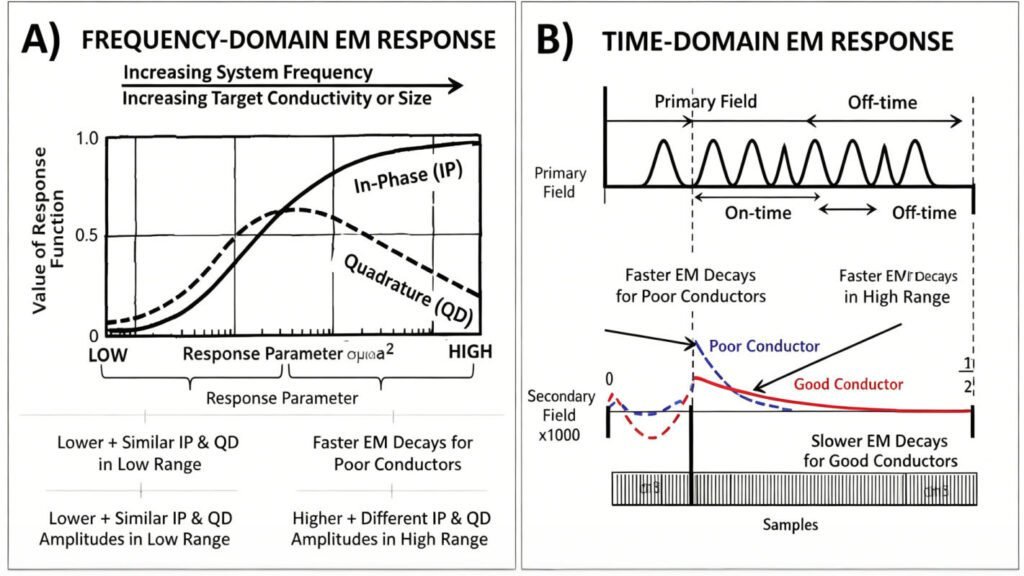
Figure 2. A) Frequency-domain EM response for In-phase and Quadrature of a conductive sphere in AC field (after Klein and Lajoie, 1980); B) Time-domain EM response for primary and secondary fields at receiver, for a Low (Poor=Blue) and High (Good=Red) conductivity zones (after Allard, 2007).
Time-domain EM generally outperforms frequency-domain EM for mineral exploration, though FEM and passive EM remain competitive in other applications. FEM systems cover nearly three decades of frequencies (~300 Hz to ~150 kHz) and measure both In-phase and Quadrature components, yielding sensitivity across roughly five orders of resistivity (0.1–50,000 Ω·m). Modern TEM systems span a broader bandwidth (~25 Hz to >100 kHz) but only capture off-time responses, limiting their sensitivity to ~4 decades and reducing performance at high resistivities. However, TEM’s lower frequency range enables detection of higher conductivities (up to 1000 S/m). Consequently, FEM’s higher frequencies yield shallower penetration than TEM. Additionally, FEM’s need to detect weak secondary fields amid strong primary fields demands rigid, compact, less powerful instruments—typically under 300 NIA dipole-moment versus 0.1–2 million NIA for TEM (100–1000× more powerful). Thus ATEM systems achieve greater depth penetration than AFEM systems through superior signal-to-noise ratio.
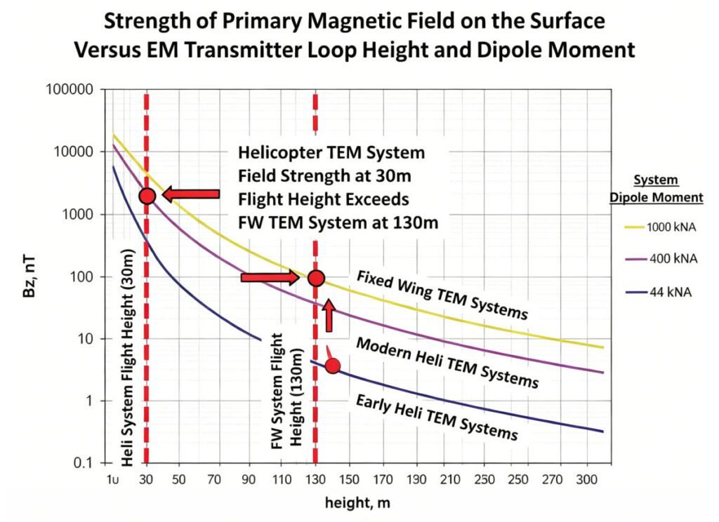
Figure 3. Theoretical primary magnetic field strengths according to flight height and transmitter dipole-moment for Fixed Wing and Heli TEM systems (after Prikhodko, 2015).
Figure 3 compares primary magnetic field strengths of FTEM and HTEM systems, showing that helicopter towed-bird systems achieve larger primary fields—and thus greater penetration—than fixed-wing systems due to lower receiver flight heights, explaining HTEM’s popularity in exploration. Passive AEM systems like AFMAG, operating at low frequencies (~25–1000 Hz), achieve the greatest depth of penetration (~km) since they avoid the 1/distance² decay of active-source primary fields (Figure 3). However, all AEM systems face high-frequency limits from dielectric permittivity effects: ~100 kHz for FEM and <1 μs for TEM. At the low end, wind-shear and external sensor noise constrain all systems to 10–15 Hz.
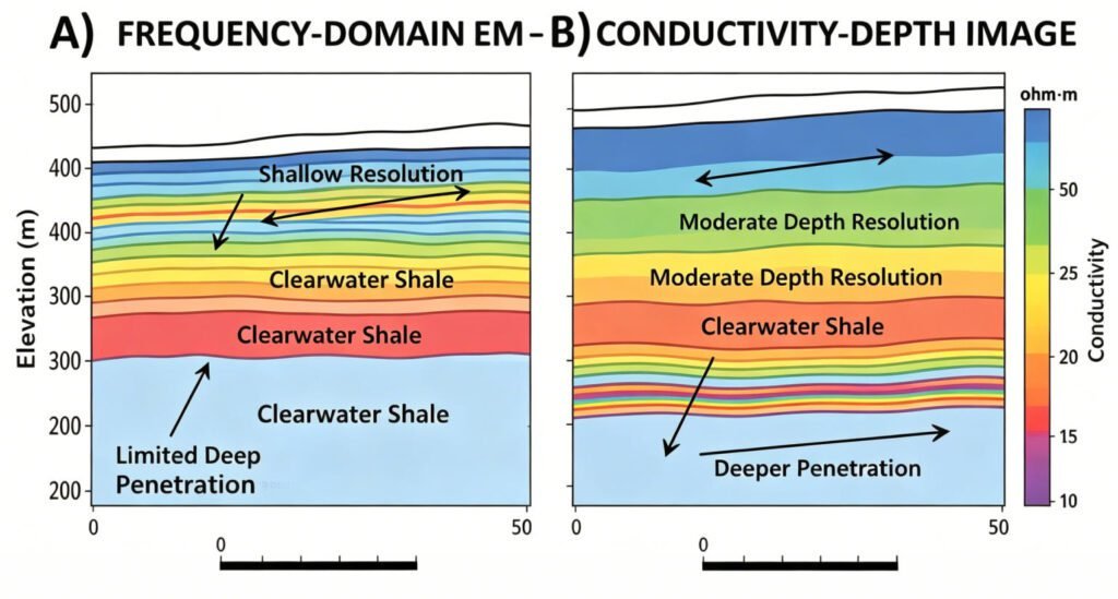
Figure 4. Conductivity-depth images (CDI) over Clearwater Shales near Fort McMurray, Alberta from A) Helicopter frequency-domain EM system and B) helicopter time-domain EM system, illustrating differences and similarities in depth-resolution between systems (after Chen et al., 2013).
Airborne TEM is preferred for thick conductive cover, deeply buried (>150 m) geology, and highly conductive targets (>10 S/m). Airborne FEM suits poorly conductive targets, resistive host rocks (>10,000 Ω·m), and near-surface (<50 m) applications such as hydrogeology, engineering, and gold or kimberlite exploration. Passive AEM is ideal for mapping large mineralized systems requiring deep investigation (>500 m). Figures 4 and 5 compare conductivity-depth images from helicopter FEM versus TEM over Clearwater shales (Alberta) and from HTEM versus passive EM over the deep Lalor deposit (Manitoba), respectively, illustrating key differences between these methods.
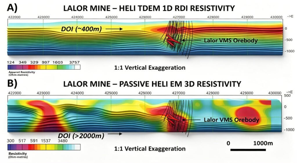
Figure 5. Resistivity-depth images for: A) Helicopter time-domain EM system, and B) helicopter passive EM system over Lalor zinc-copper-gold deposit, illustrating differences in depth investigation between systems (after Legault et al., 2014).
AEM System Development
Helicopter time-domain EM (HTEM) has been the most significant AEM development from 2000–2015. While mining geophysics drives most revenue, manufacturers have shifted from market specialization to versatile, multi-purpose systems. SkyTEM evolved from hydrogeology-focused designs to >1M dipole-moment systems for deep mineral exploration. Geotech’s VTEM, originally targeting deep mineral deposits, added full-waveform capability to improve near-surface imaging for groundwater—benefiting both markets. CGG/Fugro developed MULTIPULSE technology for shallow resolution across all its AEM platforms. Consequently, consumers now enjoy more high-end options than ever.
Conversely, AFEM development has stagnated as predicted by Allard (2007). Of 22 operational FEM systems documented in 1997, only 4–5 remain. CGG still operates RESOLVE and DIGHEM, Geotech flies IMPULSE for shallow applications, and Sander/Geotechnologies maintain fixed-wing FEM for reconnaissance. Yet industry preference for greater depth penetration has largely displaced helicopter FEM with cost-effective, lightweight HTEM systems. Despite successful GEMINI testing for deep nickel exploration, it saw no further adoption. Only two of 70 AEM 2013 papers addressed frequency-domain systems.
Meanwhile, semi-airborne systems like heli-SAM now rival ground EM, achieving >1.5 km penetration for high-conductance targets using ground loops with airborne receivers at frequencies below 15 Hz. ZTEM passive AEM is also being jointly inverted with ground MT for improved 1 km depth resolution. Recent software advances now enable IP parameter extraction from TDEM decay data. Future trends indicate airborne manufacturers will increasingly compete with ground EM systems.
Time Domain EM Systems
Over its 30-year history, Geotech Ltd of Aurora, Canada has evolved from a frequency-domain EM instrument manufacturer into likely the world’s largest helicopter time-domain EM service provider. Its VTEM platform, widely used in mineral exploration, is renowned for high signal-to-noise ratio and large dipole moments, delivering both superior data quality and deep investigation.
Geotech operates three VTEM variants: the lightweight 18 m VTEMSPEEDY with reinforced airframe for faster airspeed; the VTEMPLUS (26 m, 450k NIA); and the high-power VTEMMAX (35 m, 1.5M NIA)—the first AEM system to detect the deeply buried (>350 m) Caber North VMS deposit in Quebec. The newest VTEMXTREM exceeds 2M NIA via a larger loop and more powerful transmitter for even greater signal-to-noise. Geotech also continues operating the AEROTEM IV, featuring a rigid 12 m transmitter platform with on- and off-time measurements from a triangular 50% duty-cycle waveform at 25/30 and 75/90 Hz.
Beyond increased dipole moments for deeper penetration, VTEMPLUS uniquely incorporates a horizontal magnetic gradiometer for improved aeromagnetics among current HTDEM systems. Geotech has also implemented full-waveform adaptation across most VTEM systems at no extra cost, using continuous time-series recording, pre-survey calibration, and signal deconvolution to enhance early-time data and near-surface resolution while preserving deep investigation capability.
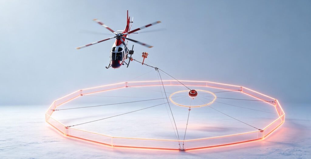
Figure 6. Geotech VTEMMAX helicopter time-domain EM system (courtesy Geotech Ltd).
CGG of Paris, one of the world’s largest geoscience companies and a leading airborne geophysical survey provider following its 2013 acquisition of Fugro Geoscience Division, is among the few operators of both fixed-wing and helicopter EM systems globally.
Its fixed-wing platforms include: MEGATEM (2M NIA, 30/90 Hz) with a transmitter loop on a Dash-7 and towed 3-component EM bird; GEOTEM (1M NIA), a similar but smaller CASA212-based system operational since the 1980s; GENESIS, a lightweight TDEM on the single-engine Cessna Grand Caravan introduced in 2007; and TEMPEST, a broadband square-wave system for groundwater and mapping using GEOTEM’s 3-component receiver. CGG also offers GRYPHON, integrating TDEM with magnetics, gravity-gradiometry, laser-scanning, and radiometrics.
On the helicopter side, HELITEM (2M NIA) is currently the highest-power helicopter TDEM in operation and was the first ATEM system to detect the deeply buried (>550 m) Lalor VMS deposit. In 2010, CGG improved HELITEM by relocating its 3-component receiver from a free-hovering bird to a fixed yoke position above the transmitter loop, closer to the ground for enhanced sensitivity. A major 2014 advancement was converting all AEM systems to MULTIPULSE technology for improved near-surface characterization.

Figure 7. CGG MEGATEM fixed-wing time-domain EM system (courtesy CGG).
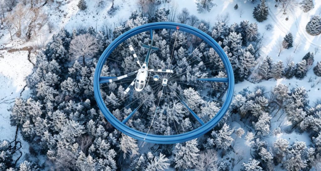
Figure 8. CGG HELITEM helicopter time-domain EM system (courtesy CGG).
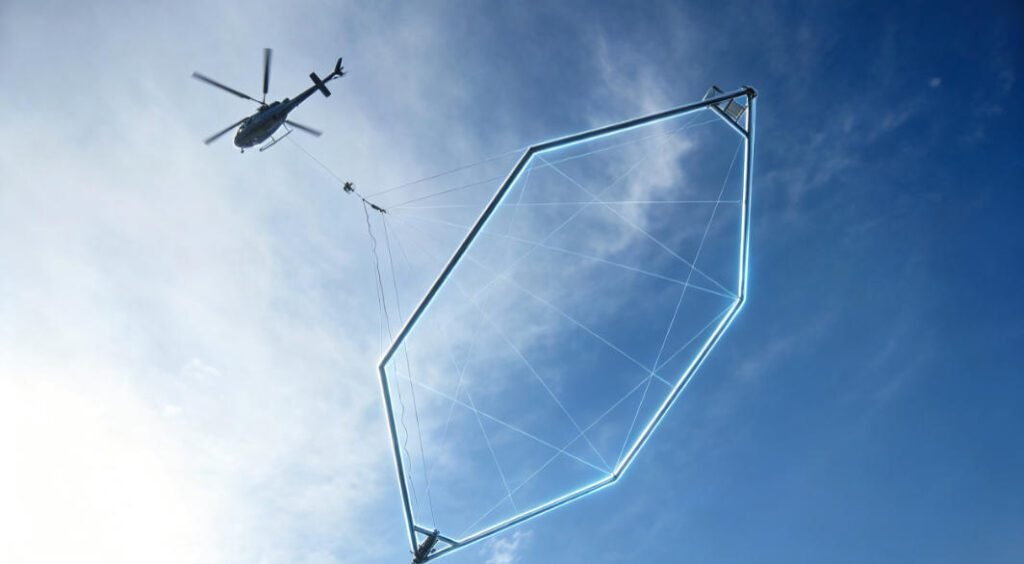
Figure 9. SkyTEM helicopter time-domain EM system (courtesy SkyTEM Aps).
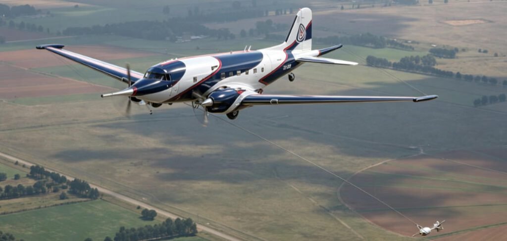
Figure 10. SpectremAir SPECTEM2000 fixed-wing time-domain EM system (courtesy SpectremAir).
SpectremAir Ltd. of Johannesburg operates the innovative fixed-wing SPECTREM2000 TDEM system, previously proprietary to DeBeers and Anglo American until 2003. It uniquely measures full on-time dB/dt fields using a 100% duty-cycle square waveform, producing a step-response signal at the receiver. SpectremAir remains CGG’s sole competitor in commercial fixed-wing AEM TDEM. The system, mounted on a Basler-modified DC-3 Dakota, is distinguished by its wide bandwidth and highest available transmitter dipole moment among AEM systems; its signal is deconvolved to a B-field step response for detecting the broadest range of conductance targets.
Other Time Domain and Frequency Domain EM Systems
Australian companies offer lightweight, low-dipole-moment HTDEM systems: GPX Surveys’ XTEM, Thomson Aviation’s S-TEM, and Geosolutions’ RepTEM. Quebec-based firms including GPR (GPR-TEM), EON Geosciences (E-THEM), and Ontario’s Pico-Envirotec (P-THEM) have all implemented variants of Kremer’s THEM system. Novatem operates a rigid helicopter TDEM with receiver loops in a central-loop, zero-field configuration. BC’s Precision GeoSurveys flies the 1TEM (based on RepTEM), while AirTEM offers an advanced HTDEM with an integrated high-sensitivity magnetometer. New Jersey-based Geotechnologies operates the EQUATOR helicopter TDEM and EM-4H fixed-wing quadrature FEM. Battelle Research Institute at Oak Ridge National Laboratory developed the boom-mounted 225 Hz TEM-8 helicopter system, flying at ~2 m for UXO detection. Ottawa’s Sander Geophysics operates the SGFEM fixed-wing FEM—the only other operational fixed-wing FEM worldwide—originally developed by Finland’s GTK and used by Britain’s BGS. Measuring secondary fields at 912 Hz–24.5 kHz via four coaxial wing-tip Rx-Tx pairs, SGFEM also acquires mag-gradiometric, laser-altimeter, radiometric, and gravity data.
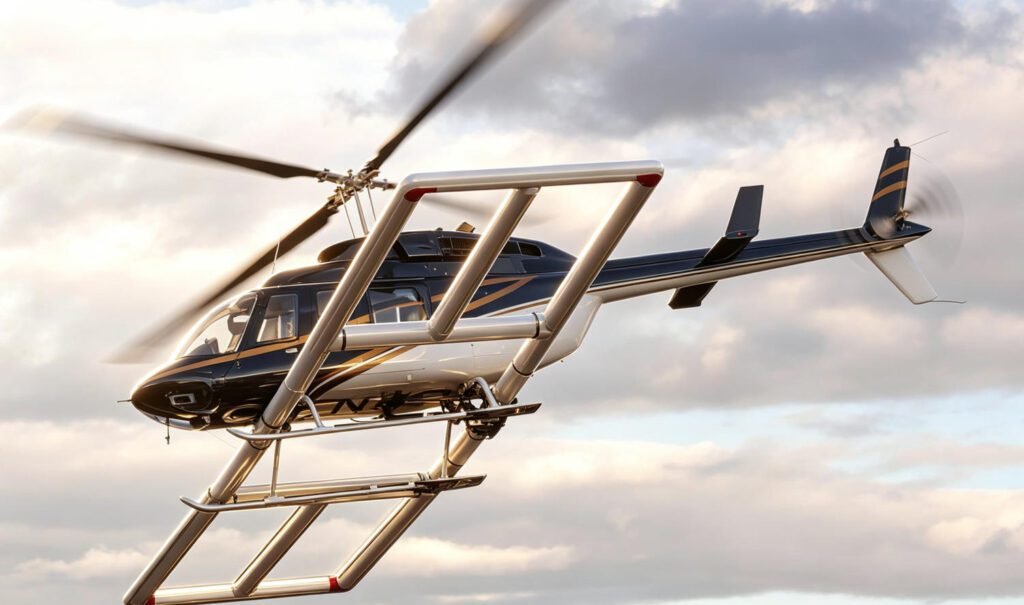
Figure 11. Battelle TEM-8 boom-mounted, time-domain EM system (courtesy Battelle Research).
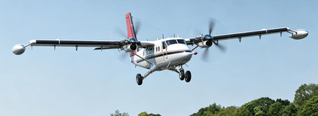
Figure 12. Sander Geophysics SGFEM fixed-wing frequency-domain EM system (courtesy Sander Geophysics).
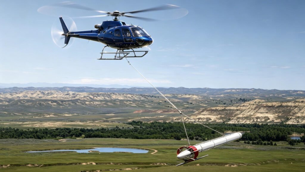
Figure 13. CGG RESOLVE helicopter frequency-domain EM system (courtesy CGG).
Passive, Semi-passive and Semi-airborne EM Systems
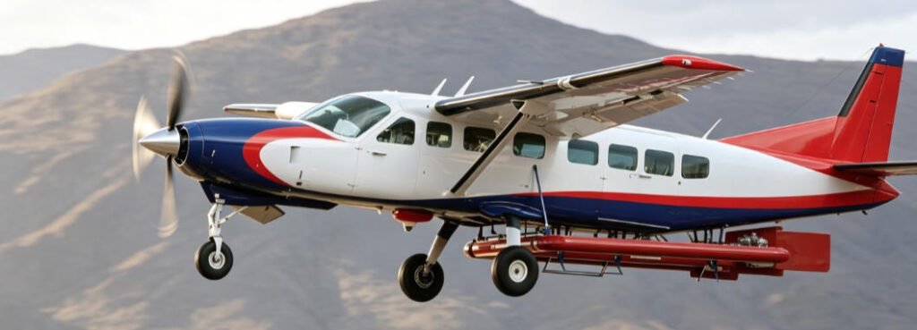
Figure 14. Geotech fixed wing ZTEM passive (natural field) EM system (courtesy Geotech Ltd).
Passive and semi-passive EM systems lack an active on-board transmitter. Passive systems use naturally occurring EM fields; semi-passive systems use distant, uncontrolled sources such as communications and powerline grids. Semi-airborne systems combine ground-based transmitters with airborne receivers, or vice versa.
Geotech Ltd., a leading HTEM provider, also dominates the non-time-domain market through its ZTEM and AirMT passive AFMAG systems. These exploit natural EM fields from worldwide thunderstorm activity (sferics), eliminating the need for an on-board transmitter. ZTEM measures the vertical (z) component via an airborne receiver and horizontal components at a remote ground station; 2D/3D inversion accounts for horizontal field differences rather than assuming uniformity. Sferics fields are uniform, horizontal, planar, and broadband, enabling kilometer-scale penetration depths unmatched by controlled-source systems. Primarily used for porphyry copper, unconformity uranium, and epithermal gold exploration, ZTEM has flown over 350,000 line-km and remains the only commercially operated airborne AFMAG technology in 30+ years. It was also the first AEM system to detect the deeply buried Lalor VMS deposit.
A fixed-wing variant, FW ZTEM, features a redesigned aerodynamic receiver with integrated total-field magnetometers, retractable via a hoist-and-cradle system. Operational since 2011, it completed its first international commercial survey in Namibia in 2014 for deep regional geological mapping.
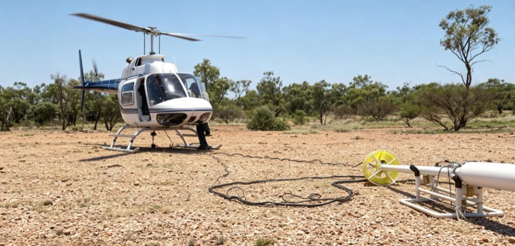
Figure 15. GAP-Discovery Geophysics Ltd.’s HeliSAM semi-airborne system (courtesy GAP Geophysics).
Semi-airborne developments include the GREATEM system. A recent innovation, heli-SAM (Sub-Audio Magnetics), was introduced in Canada by Discovery Geophysics (Vancouver) and GAP Geophysics (Brisbane). It measures EM signals from a grounded dipole or fixed loop using a cesium-vapour magnetometer towed from a helicopter. Originally designed for Australia’s deep conductive overburden, SAM operates at 4–20 Hz—well below the 15–25 Hz threshold of conventional ATEM systems—enabling resolution of highly conductive orebodies below 1.5 km depth, previously accessible only via costly ground TEM or passive AEM. Recent Canadian applications include heavy oil-sand delineation in northern Alberta and detection of the Lalor VMS orebody in northern Manitoba.
Other AEM Development
A key AEM sensor development since 2000 has been indirect B-field measurement for TDEM, achieved by integrating induction coil (dB/dt) responses during on- and off-time periods. First proposed by Smith and Annan (2000), this approach suppresses overburden responses and enhances high-conductance targets. Promised full induction measurements via SQUID or airborne ARMIT sensors have yet to reach commercial deployment, likely hindered by wind-shear noise and external interference on these sensitive instruments.
FFT time-series processing converts real waveforms to idealized impulse or step responses, used in fixed-wing systems like SPECTREM and TEMPEST, and later proposed by Macnae and Baron-Hay (2010) for helicopter AEM. Geotech implemented full-waveform deconvolution across most VTEM systems for improved early-time and near-surface characterization.
Induced polarization effects in airborne TDEM, initially described by Smith and Klein (1998) and Boyco et al. (2001) and recently examined by Kratzer and Macnae (2012), have led to AIIP (airborne inductive induced polarization) extraction as a promising post-processing parameter. Proof-of-concept 3D inversion modeling was demonstrated by Marchant et al. (2014) and Kang et al. (2014). Subsequent work by Hodges and Chen (2014b) and Kwan et al. (2015), using fast 1D TDEM inversion with Cole-Cole chargeability parameters, suggests commercial airborne IP extraction and removal for TDEM surveys is now feasible.
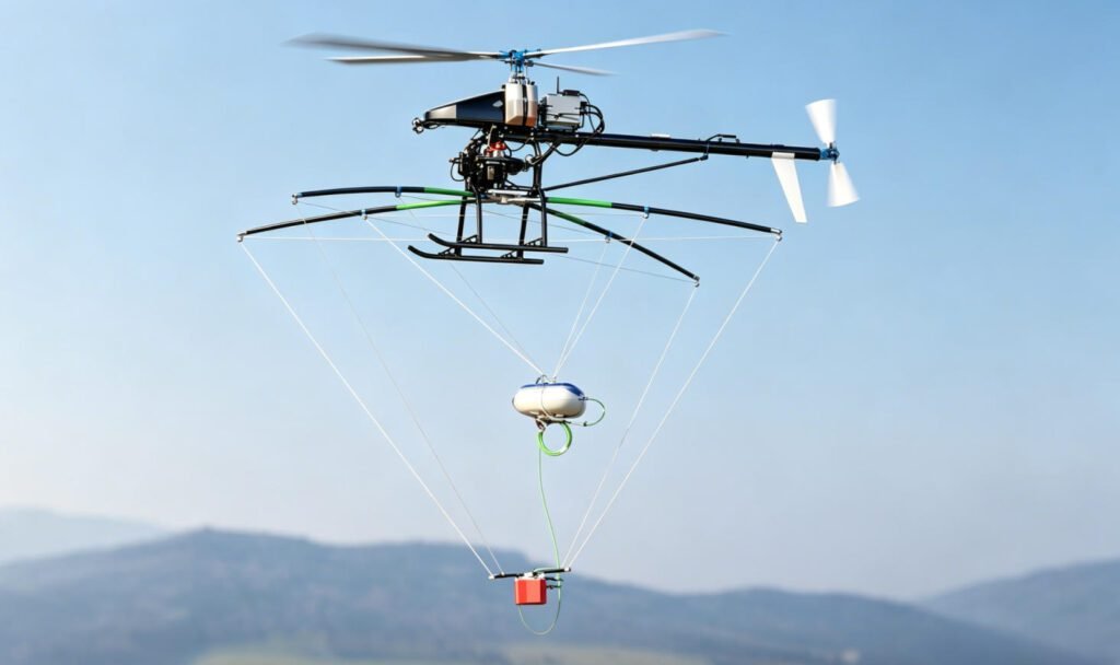
Figure 16. MGT radio electromagnetic system on Aeroscout B1-100 UAV helicopter (courtesy MGT).
UAV-based airborne EM is an emerging field. Fugro Airborne (now CGG) pioneered drone geophysical surveying, patenting a UAV for aeromagnetic data acquisition in 2005; its GEORANGER successfully collected data that year, though the program was later abandoned. In 2011, Sander Geophysics partnered with Carleton University to develop the GEOSURV II UAV for aeromagnetic surveys, now continued with Stratus Aeronautics of Calgary. More recently, Germany’s MGT (Mobile Geophysical Technologies) has integrated magnetic, infrared, radar, natural gamma-ray, and radio-EM sensors onto a UAV. Radio EM is a passive AEM technique similar to VLF but operating at 5–250 kHz, requiring only a lightweight Hx-Hy-Hz sensor aboard the drone.
Conclusions and Future Directions
Over the past five years, helicopter time-domain EM has maintained its dominance in exploration geophysics, driven by cost-effectiveness and design innovation over competing airborne and ground systems. Passive AEM has advanced for porphyry copper and epithermal gold exploration, while airborne inductive IP nears commercialization. Semi-airborne EM has also emerged as a viable competitor to ground EM for deep VMS exploration and heavy oil-sand delineation.
Though predicting future directions in this secretive, competitive field is difficult, R&D investment in improved instrumentation and innovation will persist despite industry downturns. Future priorities will be shaped by mining and mineral resource demands.
Key innovation areas include lower-frequency (<25 Hz) AEM measurements, higher-quality sensors, advanced suspension systems, and improved external noise reduction. Demand for better early-time ATEM data will continue, alongside bandwidth expansion for frequency-domain and passive EM systems at both low and high ends. Deeper investigation will be enabled by quieter, better-calibrated systems with enhanced signal-to-noise ratios. Further increases in dipole moment seem likely. Hybrid frequency-time-domain systems—ground-to-air or air-to-ground—appear logical for deep mining and hydrocarbon applications. UAV-based passive AEM shows promise, though FAA regulatory restrictions on commercial drone operations remain the primary obstacle. Airborne EM will undoubtedly continue leading geophysical applications in mining, minerals, hydrogeology, and engineering.
Reference Sources
- Allard, M., 2007, On the origin of HTEM species, In “Proceedings of Exploration 07: Fifth Decennial International Conference on Mineral Exploration” edited by B. Milkereit, 355-374.
- Bagrianski, A., Prikhodko, A., and Legault, J.M., 2014, The importance of a single transmitted waveform in the characterization of discrete conductors, SAGEEP, Extended Abstracts, 24-27
- Balch, S.J., Boyco, W.P., and Paterson, N.R., 2003, The AeroTEM airborne electromagnetic system: The Leading Edge, 22, 562-566.
- Bodger, T., Grand, T., Hearst, R., 2005, THEM-A helicopter-borne time domain electromagnetic system: presented at KEGS Airborne Symposium, Toronto.
- Boyko, W., Paterson, N.R. and Kwan, K., 2001, AeroTEM characteristic and field results: The Leading Edge, 20, 1130-1138.
- Chen, T., Miles, P., and Hodges, G., 2013, The MULTIPULSE system – high resolution and high power with one TDEM system: AEM 2013, 6TH International AEM Conference and Exhibition, Expanded Abstracts, 4 p.
- Chubak, G., Cattach, M., Kowalczyk, P., and Napier, S., 2014, SAM (sub-audio magnetics) detection and delineation of bitumen deposits: Geoconvention 2014, Expanded Abstracts, 8 p.
- Doll, W.E., Gamey, T.J., Holladay, J.S., Sheehan, J.R., Norton, J.M., Beard, L.P., Lee, J.L.C., Hanson, A.E., and Raye, M.L., 2010, Results of a high-resolution airborne TEM system demonstration for unexploded ordnance detection: Geophysics, 75, B211-B220.
- Effersø, F., 2014, SkyTEM: a versatile HELITEM system, presented at Annual Meeting of Association of Exploration Geophysicists, AEG, Hyderabad, India.
- Eröss, R., Stoll, J.B., Bergers, R., and Tezhan, B., 2013, Three-component VLF using an unmanned aerial system as sensor platform: First Break, 31, 33-40.
- Fountain, D., 1998, Airborne electromagnetic systems – 50 years of development: Exploration Geophysics, 29, 1-11.
- Fountain, D., 2008, 60 years of airborne EM – focus on the last decade: AEM 2008, 5th International Conference on Airborne Electromagnetics, conference abstracts, 8 p.
- Fountain, D., Smith, R., Payne, T., and Lemieux, J., 2005, A helicopter time-domain EM system applied to mineral exploration: system and data: First Break, 23, 73-78.
- Greenough, G., and Palmer, P., 2010, McFauld’s Lake Project, James Lowlands, Ontario, Canada: Technical report and resource estimate, prepared for Noront Resources Ltd. by Golder Associates, 241 p.
- Hodges, G., 2013, The power of frequency domain: when you should it: AEM 2013, 6TH International AEM Conference and Exhibition, Expanded Abstracts, 5 p.
- Hodges, G., and Chen, T., 2014a, Lalor HELITEM test results: presented at Exploration for deep VMS ore bodies: The Hudbay Lalor case study, Lalor Symposium by Hudbay Minerals Inc. and Manitoba Geological Survey, Winnipeg, CAN.
- Hodges, G., and Chen, T., 2014b, IP effect in airborne TDEM data: Model studies and field examples: SEG, Expanded Abstracts, 5 p.
- Hodges, G., and Chen, T., 2014c, Geobandwidth: comparing time domain electromagnetic waveforms with a wire loop model: Exploration Geophysics, 46, 58-63.
- Holtham, E., and D. Oldenburg, 2008, Three-dimensional forward modeling and inversion of Z-TEM data: SEG, Expanded Abstracts, p. 564–568.
- Kaminski, V. F., P. Kuzmin, and J. M. Legault, 2010, AirMt — Passive airborne EM system: Presented at the 3rd CMOS-CGU Congress, Ottawa, CAN.
- Kaminski, V.F., and Viezzoli, A., 2015, personal communication.
- Kang, S., Oldenburg, D.W., Yang, D., and Marchant, D., 2014, SEG, Expanded Abstracts, 1785-1789.
- Keeler, K.N., McConnell, T.J., Miles, P.J., and Partner, R.T., 2005, Unmanned airborne vehicle for geophysical surveying: Australia Patent AU2005291731, for Fugro Airborne Surveys Corp.
- Killeen, P.G., 2006, Exploration Trends and Developments in 2005: The Northern Miner, Toronto, CAN, 8 p.
- Killeen, P.G., 2011, Exploration Trends and Developments in 2010: The Northern Miner, Toronto, CAN, 28 p.
- Killeen, P.G., 2012, Exploration Trends and Developments in 2011: The Northern Miner, Toronto, CAN, 47 p.
- Killeen, P.G., 2013, Exploration Trends and Developments in 2012: The Northern Miner, Toronto, CAN, 48 p.
- Killeen, P.G., 2014, Exploration Trends and Developments in 2013: The Northern Miner, Toronto, CAN, 28 p.
- Killeen, P.G., 2015, Exploration Trends and Developments in 2014: currently in-press.
- Klein, J., & Lajoie, J. J., 1980, Electromagnetic prospecting for minerals: In “Practical geophysics for the Exploration geologists”, edited by R. Van Blaricom, Northwest Mining Association, 239-290.
- Kratzer, T., and Macnae, J. C., 2012, Induced polarization in airborne EM: Geophysics, 77, p. E317-327.
- Kwan, K., and Prikhodko, A., 2015, personal communication.
- Kwan, K., Prikhodko, A., Legault, J.M., Plastow, G., Xie, J. and Fisk, K., 2015, Airborne inductive induced polarization chargeability mapping of VTEM data: ASEG, Extended Abstracts, 4 p.
- Labson, V. F., A. Becker, H. F. Morrison, and U. Conti, 1985, Geophysical exploration with audio frequency natural magnetic fields, Geophysics, 50, p. 656–664.
- Lane, R., A. Green, C. Golding, M. Owers, P. Pik, C. Plunkett, D. Sattel, and B. Thorn, 2000, An example of 3D conductivity mapping using the TEMPEST airborne electromagnetic system: Exploration Geophysics, 31, 162–172.
- Legault, J.M., 2012, Ten years of passive airborne AFMAGF EM development for mineral exploration: SEG, Expanded Abstracts, 6 p.
- Legault, J.M., Plastow, G., Zhao, S., Bournas, N., Prikhodko, A., and Orta, M., 2014, ZTEM and VTEM airborne EM and magnetic results over the Lalor VMS deposit region, near Snow Lake, Manitoba: The Hudbay Lalor case study, Lalor Symposium by Hudbay Minerals Ltd.. and Manitoba Geological Survey, Winnipeg, CAN.
- Legault, J.M., and Wannamaker, P.E, 2014, Two-dimensional joint inversion of ZTEM and MT plane-wave EM data for near-surface applications, SAGEEP, Extended Abstracts, 18-23.
- Leggatt, P., 2013, Extending the range of conductivities detected by the Spectrem AEM system: AEM 2013, 6TH International AEM Conference and Exhibition, Expanded Abstracts, 1 p.
- Leggatt, P. B., P. S. Klinkert, and T. B. Hage, 2000, The Spectrem airborne electromagnetic system — Further developments: Geophysics, 65, p. 1976–1982.
- Lo, B., and M. Zang, 2008, Numerical modeling of Z-TEM (airborne AFMAG) responses to guide exploration strategies: SEG, Expanded Abstracts, p. 1098–1101.
- Macnae, J., 2007, Developments in broadband airborne electromagnetics in the past decade In “Proceedings of Exploration 07: Fifth Decennial International Conference on Mineral Exploration” edited by B. Milkereit, 387-398.
- Macnae, J., 2012, Design and testing of ARMIT magnetic field sensor for EM systems: ASEG, Extended Abstracts, 3 p.
- Macnae, J., 2015, personal communication.
- Macnae, J., and Baron-Hay, S., 2010, Reprocessing strategy to obtain quantitative early time data from historic VTEM surveys: ASEG, Extended Abstracts, 4 p.
- Marchant, D., Haber, E., and Oldenburg, D.W., 2014, Three-dimensional modeling of IP effects in time-domain electromagnetic data: Geophysics, 79, p. E303-E314.
- McNeil, J.D., and Labson, V.F., 1991, Geological mapping using VLF fields, in, “Electromagnetic Methods in Applied Geophysics”, edited by M.N. Nabighian, Society of Exploration Geophysics, p. 521-640.
- Mogi, T., Yoshikazu T., Morikawa T. and Jomori N., 1998, Development of Grounded Electrical Source Transient EM (GREATEM), Exploration Geophysics, 29, p. 61-64.
- Parker, C., Rudd, J., Cattach, M., and Kuttai, J., 2014, The results of a HeliSAM test survey over the Lalor VMS deposit, Snow Lake, Manitoba: presented at Exploration for deep VMS ore bodies: The Hudbay Lalor case study, Lalor Symposium by Hudbay Minerals Inc. and Manitoba Geological Survey, Winnipeg, CAN.
- Pedersen, L. B., 1998, Tensor VLF measurements: Our first experiences: Exploration Geophysics, 29, 52–57.
- Prikhodko, A., 2015, personal communication.
- Prikhodko, A., Legault, J.M., Kwan, K., Eadie, T., Fisk, K., Oldenborger, G.A., Viezzoli, A., Gloaguen, E., Smith, B.D., and Best, M.B., 2013, Recent AEM case study examples using a full waveform system for near-surface applications:, AEM 2013, 6TH International AEM Conference and Exhibition, Expanded Abstracts, 5 p.
- Samson, C., Caron, R., and McLeod, T., 2013, Unmanned airborne vehicles in geophysics: an emerging technology for airborne surveys: presented at KEGS geophysics breakfast lecture, Quebec Exploration Conference, Quebec City, CAN.
- Samson, C., 2014, personal communication.
- Sattel, D., 2006, A brief discussion of helicopter time-domain electromagnetic systems: SEG, Expanded Abstracts, 1268-1272.
- Smith, R.S., 2010, Airborne electromagnetic methods: applications to minerals, water and hydrocarbon exploration: CSEG Recorder, 35, 4 p.
- Smiarowski, A., and Macnae, J., 2013, Detection of a perfect conductor with an airborne electromagnetic system: The Gemini field test: Geophysics, 78, p. E249-E259
- Smith, R.S. and Annan, A.P., 2000, Using an induction coil sensor to indirectly measure the B-field response in the bandwidth of the transient electromagnetic method: Geophysics, 65, 1489-1494.
- Smith, R.S., and Fountain, D., 2005, The MEGATEM fixed-wing transient EM system applied to mineral exploration: a discovery case history: CSEG Recorder, 30, 8 p.
- Smith, R. S. and J. Klein, 1996, A special circumstance of airborne induced polarization measurements: Geophysics, 61, 66–73.
- Sørensen, K.I. and Auken, E., 2004, SkyTEM – a new high-resolution helicopter transient electromagnetic system: Exploration Geophysics, 35, 191-199.
- Sørensen, K.I., Mai, S., Mohr, K.R., and Nyboe, N.S., 2013, Development of high dipole TDEM systems: AEM 2013, 6TH International AEM Conference and Exhibition, Expanded Abstracts, 2 p.
- Stoll, J.B., 2015, personal communication: Stoll, J.B., Moritz, D., Eröss, R., Tezkan, B., and Bergers, R., Airborne RadioEM using a remotely piloted aircraft system, unpublished white paper, 4 p.
- Thomson, S., Fountain, D., and Watts, T., 2007, Airborne geophysics – evolution and revolution: In “Proceedings of Exploration 07: Fifth Decennial International Conference on Mineral Exploration” edited by B. Milkereit, 19-37.
- Verma, S., 2013, Host medium effects on the response of subsurface conductors in helicopter borne time domain electromagnetic exploration: AEM 2013, 6TH International AEM Conference and Exhibition, Expanded Abstracts, 4 p.
- Viezzoli, A., 2014, Rethink groundwater mapping and management strategies for unconventional hydrocarbons using airborne EM: Geoconvention 2015, Expanded Abstracts, 6 p.
- Vovenko, T., Moilanen, E., Volkovitsky, A., and Karshakov, E., 2013, New abilities of quadrature EM systems: AEM 2013, 6TH International AEM Conference and Exhibition, Expanded Abstracts, 4 p.
- Vallée, M.A., Smith, R.S., and Keating, P., 2011, Metalliferous mining geophysics— State of the art after a decade in the new millennium: Geophysics, 76, p. W31–W50.
- Volkovitsky, A., and Karshakov, E., 2013, Airborne EM systems variety: what is the difference: AEM 2013, 6TH International AEM Conference and Exhibition, Expanded Abstracts, 4 p.
- Ward, S. H., 1959, AFMAG — Airborne and ground: Geophysics, 24, 761–787
- Witherly, K., 2009, Results of various airborne EM systems over a target of high conductance: ASEG. Extended Abstracts, 4 p.
- Witherly, K., Irvine, R., and Morrison, E.B., 2004, The Geotech VTEM time domain EM system, SEG, Expanded Abstracts, 5 p.
- Yin, C. and Hodges, G., 2005, Influence of displacement currents on the response of helicopter electromagnetic systems, Geophysics, 70, G95-G100.
FAQ
Q1: What is the difference between time-domain EM (TEM) and frequency-domain EM (FEM)?
TEM systems measure secondary field decay during transmitter off-time, offering deeper penetration (100-1000× more powerful, 0.1–2M NIA dipole moment) and better performance for conductive targets >10 S/m. FEM systems induce sinusoidal fields, measure In-phase and Quadrature components, and excel at near-surface (<50 m) resolution with sensitivity spanning 0.1–50,000 Ω·m resistivity range.
Q2: How deep can helicopter time-domain EM (HTEM) systems penetrate?
Modern HTEM systems like VTEMMAX (1.5M NIA) and HELITEM (2M NIA) can detect deposits buried >350–550 m deep. The VTEMXTREM system with >2M NIA dipole moment achieves even greater penetration. Depth depends on dipole moment, frequency content, and ground conductivity—lower frequencies and higher dipole moments enable deeper investigation.
Q3: Which AEM system is best for mineral exploration vs groundwater mapping?
For mineral exploration (deep conductive targets >150 m), choose HTEM systems (VTEM, HELITEM, SkyTEM516). For groundwater and near-surface (<100 m) applications, FEM systems like RESOLVE or DIGHEM are preferred. For very deep targets (>500 m) or porphyry copper/gold, passive systems like ZTEM offer kilometer-scale penetration. Semi-airborne heli-SAM excels at >1.5 km depth for high-conductance orebodies.
Q4: What is passive airborne EM and how does ZTEM work?
Passive AEM systems like ZTEM use naturally occurring EM fields from worldwide thunderstorm activity (sferics) instead of onboard transmitters. ZTEM measures the vertical (z) component via airborne receiver and horizontal components at a remote ground station. 2D/3D inversion accounts for horizontal field differences. Benefits include uniform, planar, broadband natural fields enabling unmatched kilometer-scale penetration depths, with 350,000+ line-km flown commercially.
Q5: What are the latest innovations in AEM technology since 2015?
Key innovations include: (1) Multi-moment/multi-pulse technology (SkyTEM MULTIMOMENT, CGG MULTIPULSE) for simultaneous shallow and deep imaging; (2) Full-waveform deconvolution for improved early-time data; (3) Airborne IP extraction from TDEM decay data using Cole-Cole parameters; (4) Semi-airborne heli-SAM systems reaching <15 Hz for >1.5 km penetration; (5) UAV-mounted passive radio-EM sensors (5–250 kHz); and (6) B-field measurement via induction coil integration.