Welcome to Geotech!

What is Geophysical Exploration?
In the field of earth sciences, geophysical exploration technologies serve as powerful tools for revealing the mysteries beneath the earth’s surface, continuously driving the development and progress of multiple industries. A series of technologies such as Electrical Resistivity Tomography (ERT), Resistivity Imaging and Electrical Imaging, High-Density Electrical Method, DC Resistivity Sounding, Induced Polarization (IP), and Vertical Electrical Sounding (VES) play a crucial role in Environmental Site Assessment, environmental testing, engineering surveys, and mineral resource exploration. At the same time, the development of these technologies is closely linked to geophysics and Geotechnical Investigation, providing indispensable technical support for related fields.
ERT Technology: Accurately Gaining Insight into Subsurface Structures
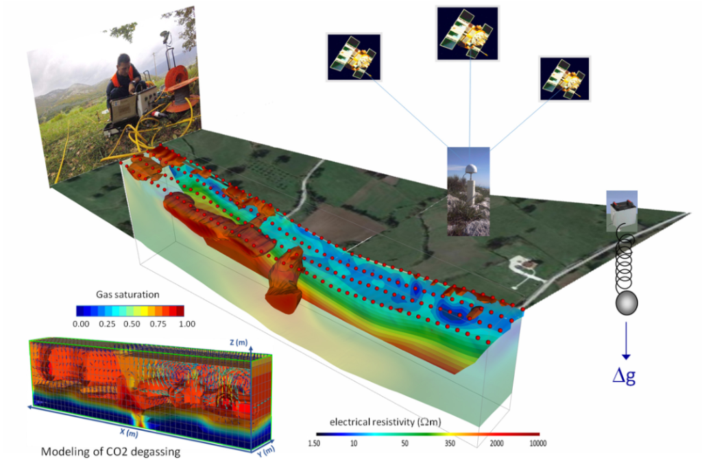
Electrical Resistivity Tomography (ERT), that is, resistivity tomography technology, arranges an electrode array on the ground, injects current into the subsurface, measures the potential distribution, and uses the resistivity differences of different geological bodies to construct a three-dimensional resistivity model of the subsurface. In Environmental Site Assessment projects, ERT can be used to detect soil and groundwater pollution. Since pollutants can change the resistivity of subsurface media, ERT can accurately locate the polluted areas and their diffusion paths, providing key evidence for environmental treatment. In the assessment of an industrial pollution site, ERT technology clearly presented the extent and depth of the polluted soil underground, helping the environmental protection department formulate a targeted remediation plan.
Resistivity Imaging and Electrical Imaging Technologies: High-Resolution Subsurface Imaging
Resistivity Imaging and Electrical Imaging technologies are essentially based on resistivity differences to generate subsurface images. They process the measured data through complex algorithms to obtain high-resolution subsurface structure images. In the field of engineering surveys, for the foundation surveys of large construction projects, these technologies can accurately detect the distribution of underground rocks and soils and discover potential geological defects in advance, such as faults and cavities. For example, in the preliminary survey of a bridge project, using resistivity imaging technology, the karst caves underground were accurately identified, avoiding major potential safety hazards in subsequent construction.
High-Density Electrical Method: Comprehensive and Detailed Detection of Subsurface Targets
The High-Density Electrical Method is an efficient geophysical exploration method. It achieves comprehensive coverage and detailed detection of the subsurface target area through a high-density electrode arrangement. Compared with traditional methods, it has a large amount of data collection, high resolution, and a deeper detection depth. In the investigation of geological disaster hidden dangers, this method can quickly identify the geological weak areas that may trigger disasters such as landslides and debris flows. In the geological disaster prevention and control project in mountainous areas, the high-density electrical method accurately detected the boundaries and internal structures of potential landslides, providing important data for formulating scientific prevention and control measures.
DC Resistivity Sounding and VES: Detecting Resistivity Changes at Different Depths Underground
DC Resistivity Sounding and Vertical Electrical Sounding (VES) technologies are mainly used to measure the resistivity changes at different depths underground. They obtain resistivity information at different depths by changing the distance between the power supply electrodes and the measuring electrodes. In the exploration of underground water resources, these technologies can determine the location, thickness, and resistivity characteristics of aquifers, providing key data for water resource development. When searching for underground water sources in arid areas, DC Resistivity Sounding and VES technologies accurately located potential aquifers, meeting part of the local water demand.
Induced Polarization (IP) Technology: Effectively Distinguishing Underground Minerals and Rocks
Induced Polarization (IP), that is, the induced polarization technology, uses the differences in the secondary potentials generated by different minerals and rocks under the excitation of current to distinguish the types of underground substances. In mineral exploration, this technology is of great significance for finding metal ores, sulfide ores, etc. By identifying the induced polarization characteristics of underground substances, exploration personnel can quickly lock in potential ore bodies and improve exploration efficiency. In a large-scale gold mine exploration project, the IP technology helped the exploration team accurately find the location of the gold ore body, greatly promoting the progress of the project.
Comprehensive Application of Geophysical Technologies in Multiple Fields
In practical work, these geophysical technologies are not used in isolation. In the Geotechnical Investigation of large-scale engineering projects, it is often necessary to comprehensively use multiple technologies. For example, in the preliminary survey of urban subway construction, engineering geophysical methods are first used for large-area general surveys. The High-Density Electrical Method is used to preliminarily determine the general situation of the subsurface geological structure, and then combined with the ERT technology for detailed imaging of key areas. At the same time, DC Resistivity Sounding and VES technologies are used to detect changes in the groundwater level and formation resistivity, providing comprehensive and accurate geological information for subway line planning and construction design. In environmental testing, geophysical technologies are combined with chemical analysis methods to more comprehensively evaluate the environmental pollution situation. Geophysical technologies determine the scope and depth of pollution, and chemical analysis further determines the types and concentrations of pollutants, providing complete data support for environmental remediation.
The Collaborative Development of Geophysical Technologies and Geophysics
The continuous progress of geophysical exploration technologies is inseparable from the support of geophysics theories. The research achievements of geophysics provide a theoretical basis for the principle optimization and method improvement of these technologies. For example, in-depth research on the earth’s electromagnetic field, physical properties of rocks, etc., has promoted the development of technologies such as Electrical Resistivity Tomography (ERT) and Induced Polarization (IP). At the same time, the data obtained by geophysical exploration technologies in practical applications provide rich materials for the research of geophysics, promoting a deeper understanding of the earth’s internal structure and geological processes. The two promote and develop in coordination with each other.
With the continuous advancement of science and technology, geophysical exploration technologies are constantly innovating in terms of hardware equipment, data processing algorithms, etc. The application of new electrode materials and sensors has improved the accuracy and stability of data collection. The application of artificial intelligence and big data technologies in data processing can more quickly and accurately invert subsurface structures. In the future, geophysical exploration technologies will develop in the direction of higher efficiency, greater accuracy, and more intelligence, providing more powerful technical support for Environmental Site Assessment, engineering surveys, mineral exploration, and other fields, and contributing to the research of earth sciences and the sustainable development of human society.
Among the family of geophysical exploration technologies, technologies such as Electrical Resistivity Tomography (ERT), Resistivity Imaging and Electrical Imaging, High-Density Electrical Method, DC Resistivity Sounding, Induced Polarization (IP), and Vertical Electrical Sounding (VES) each have their own advantages, jointly forming a complete technical system to escort the development of multiple industries.
