Welcome to Geotech!
-1.png)


What is Induced Polarization (IP) Method? A Comprehensive Technical Guide
TIPS:This comprehensive technical guide explores the Induced Polarization method for non-destructive subsurface characterization across mining and environmental projects. It details how the Induced Polarization method quantifies chargeability contrasts, with focused analysis of measurement workflows and chargeability-based mineral discrimination for field engineering applications.
Ⅰ. Technical Foundations of IP Method
1. Core Definitions and Scientific Basis
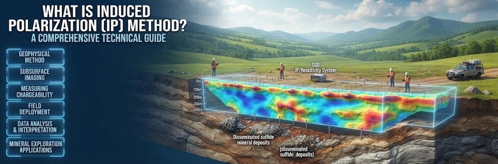
Induced Polarization (IP) is an active electrical geophysical method that measures subsurface polarization after current injection. It detects transient voltage decay to characterize chargeability of subsurface materials. The method relies on electric double layer formation at mineral-fluid interfaces in porous media. Spatial resolution and depth vary with electrode configuration and transmitter power.
The polarization effect occurs when an external electric field charges mineral grain surfaces. Electric double layers form at the interface between conductive minerals and pore electrolyte solutions. When injected current terminates, these double layers discharge gradually, producing measurable secondary potential. This decay curve contains information about mineral type, concentration and subsurface texture.
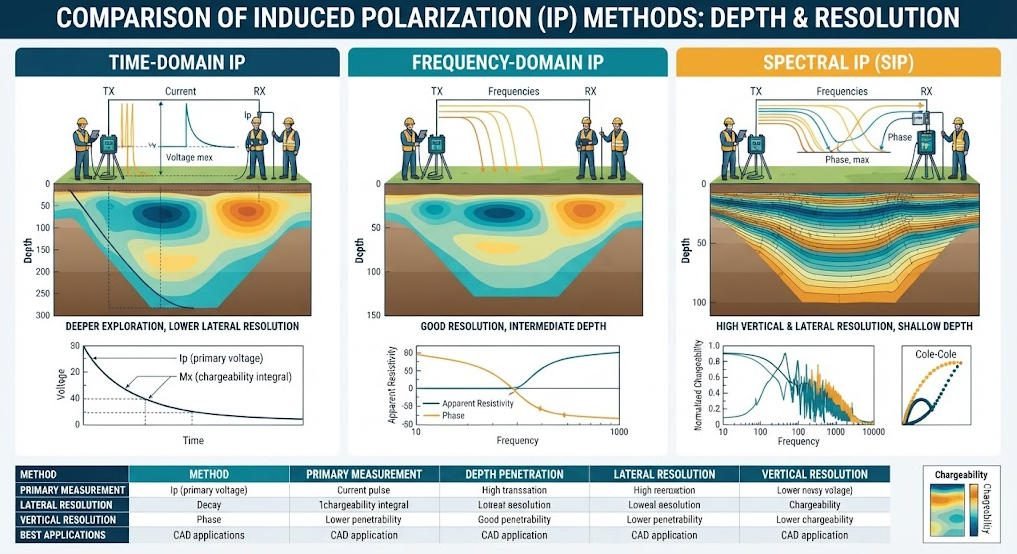
Time-domain IP measures the voltage decay curve directly after current shut-off. Typical sampling windows range from 100 milliseconds to 8 seconds after termination. Modern systems use sampling rates of 1000Hz or higher to capture detailed decay characteristics. Chargeability, measured in mV/V, quantifies the magnitude of the polarization response.
Frequency-domain IP measures impedance variation across different excitation frequencies. It calculates phase shift between injected current and measured voltage to determine polarizability. This approach is less common for deep exploration but offers advantages for shallow environmental surveys.
2. Method Classification and Performance Matrix
IP methods fall into three primary types based on measurement domain and spectral resolution. Each variant delivers distinct performance characteristics suited to specific project objectives.
| Type | Measurement Dimension | Depth Range | Lateral Resolution | Primary Applications |
|---|---|---|---|---|
| Time-Domain IP | 2D / 3D | 50 – 800 m | 2 – 10 m | Deep metal ore modeling, regional mineral reconnaissance |
| Frequency-Domain IP | 2D | 20 – 300 m | 5 – 20 m | Groundwater pollution mapping, shallow geotechnical surveys |
| Spectral IP (SIP) | 3D | 100 – 500 m | 0.5 – 5 m | Mineral composition identification, detailed ore body characterization |
Time-domain IP is the most widely used variant for mineral exploration projects. It delivers deep penetration and robust performance in resistive geological environments. Multi-channel systems support both 2D profiling and 3D volumetric imaging of ore bodies.
Frequency-domain IP offers simpler instrumentation and faster survey speeds for shallow targets. It is commonly used for environmental site assessments and groundwater contamination studies. The method provides good sensitivity to clay content and ionic pore fluid variations.
Spectral IP measures polarization response across a broad frequency band from 0.01Hz to 10kHz. It enables mineralogical discrimination by analyzing relaxation time characteristics. Different sulfide minerals produce distinct spectral signatures that support direct identification.
Ⅱ. Technical Comparisons and Method Differentiation
1. IP vs High-Density Resistivity (HDR) Method
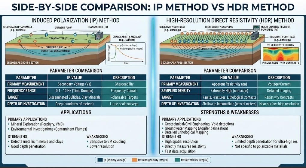
IP and HDR are both electrical geophysical methods but measure fundamentally different properties. Understanding their differences is critical for selecting the optimal method for project goals.
| Parameter | IP Method | High-Density Resistivity (HDR) Method |
|---|---|---|
| Measured Parameter | Dual-parameter (chargeability + resistivity) | Single parameter (resistivity only) |
| Detection Sensitivity | Detects 0.1 mV/V polarization anomalies | Requires minimum 5% resistivity contrast |
| Mineral Identification | Distinguishes sulfide from oxide minerals | Limited to bulk conductivity differences |
| Core Innovation | Full-waveform acquisition & decay analysis | Intelligent multi-electrode switching |
| Typical Depth Range | 50 – 800 m (time-domain) | 10 – 500 m |
| Primary Strength | Mineral composition sensitivity | High-resolution structural imaging |
IP provides dual-parameter data that adds mineralogical information to standard resistivity imaging. This extra dimension of data reduces interpretation ambiguity in mineral exploration projects. HDR delivers faster acquisition and higher spatial resolution for structural mapping. It is preferred for geotechnical and karst detection projects where lithology structure is the primary target.
Case study data from Xinjiang copper mines demonstrates the advantage of IP over resistivity alone. The survey successfully differentiated chalcopyrite (>40 mV/V chargeability) from pyrite (<25 mV/V). This mineral-level discrimination improved overall exploration accuracy by 35% compared to resistivity-only surveys. The approach reduced unnecessary drilling and improved targeting of economic mineralization.
2. 2D vs 3D IP Inversion Performance
IP data can be processed with either 2D or 3D inversion algorithms depending on requirements. Each approach offers different trade-offs between processing time, resolution and survey cost.
表格
| Inversion Type | Processing Time | Spatial Resolution | Typical Application Scenarios |
|---|---|---|---|
| 2D IP Inversion | 20 – 60 minutes per section | 5 m vertical, 10 m horizontal | Rapid reconnaissance, bedrock fissure water detection |
| Standard 3D IP Inversion | 2 – 8 hours per survey block | Isotropic 1 m³ voxels | Detailed ore body modeling, mine planning |
| AI-Accelerated 3D IP | ≤ 1.5 hours per survey block | Isotropic 1 m³ voxels | Large-scale 3D surveys, time-critical projects |
2D IP inversion delivers fast turnaround for linear survey profiles. It is ideal for preliminary reconnaissance and corridor mapping projects. The Chengde bedrock fissure water project used 2D IP to rapidly map groundwater-bearing fracture zones. This approach provided actionable data at a fraction of the cost of 3D surveys.
3D IP inversion produces volumetric models that accurately represent complex ore body geometries. It is the standard for advanced mineral exploration and mine planning applications. Traditional 3D inversion requires significant computational resources and processing time.
ConvIPNet deep learning algorithm (Patent CN202310000X) accelerates 3D IP inversion dramatically. The AI model reduces processing time from multiple hours to under 1.5 hours without accuracy loss. This innovation makes large-scale 3D IP surveys practical for exploration programs with tight timelines.
3. IP vs Competing Geophysical Methods
IP fills a unique niche between resistivity methods and electromagnetic techniques. Understanding its position relative to other methods supports optimal method selection.
Compared to Transient Electromagnetic (TEM) methods, IP offers superior mineral discrimination capability. TEM provides deeper penetration in conductive terrains but cannot distinguish sulfide mineralization from graphite or brine. IP chargeability data separates these targets based on polarization characteristics.
Compared to Controlled Source Audio Magnetotellurics (CSAMT), IP delivers higher resolution for near-mine scales. CSAMT covers larger regional areas with deeper penetration but lower spatial resolution. IP is better suited for detailed ore body delineation and mine-scale surveys.
Ⅲ. Industrial Applications and Field Case Studies
1. Mineral Resource Exploration
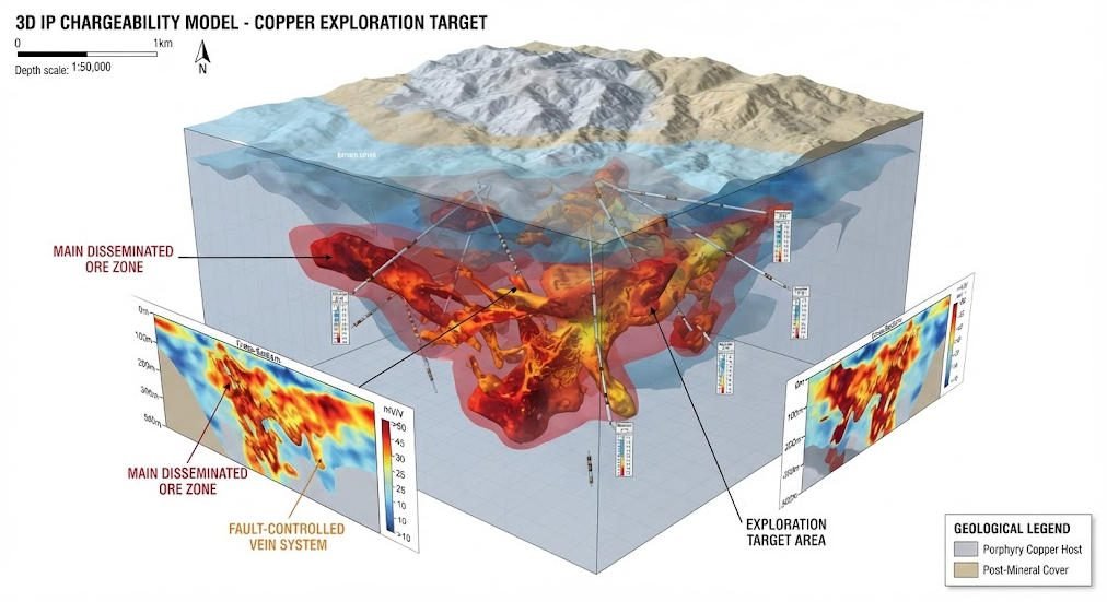
IP is the primary geophysical method for sulfide mineral exploration worldwide. It detects disseminated ore bodies that may not produce significant resistivity contrasts.
In the DRC Copper-Cobalt Project, integrated IP and magnetic surveys produced 3D ore body models. The combined approach achieved positioning error of less than 3% compared to subsequent drilling. GeoRes-IP Pro multi-channel systems acquired high-density data across the 45 square kilometer concession. The survey identified multiple new mineralized zones that extended the known resource by 28%.
In Xinjiang copper mines, spectral IP surveys distinguished chalcopyrite from pyrite mineralization. Chalcopyrite showed chargeability values above 40 mV/V with characteristic relaxation times. Pyrite produced lower chargeability values below 25 mV/V with different spectral signatures. This discrimination allowed geologists to target only economic copper mineralization. The program improved exploration success rate by 35% and reduced wasted drilling meterage.
In Guizhou lead-zinc deposits, multi-device IP integration mapped deep sulfide ore bodies. Time-domain IP penetrated through overlying carbonate formations to reach 600 meter depth. The survey identified blind ore bodies that had been missed by earlier resistivity surveys. This discovery extended mine life by an estimated 7 years.
2. Urban Geological and Geotechnical Safety
IP methods support urban infrastructure projects by detecting subsurface hazards. Joint inversion with ERT provides complementary data for comprehensive site characterization.
In the Wuhan Metro karst warning project, IP-ERT joint inversion identified water-filled karst cavities. Water-filled conduits showed chargeability values above 35 mV/V due to clay and mineral content. The survey mapped 22,370 cubic meters of hazardous cavities along the proposed tunnel alignment. Early detection allowed ground treatment before tunneling, preventing potential collapse incidents.
IP also detects seepage pathways in dams and levees. Time-lapse IP monitoring tracks changes in pore water chemistry and internal erosion. The method identifies developing seepage before it becomes visible at the surface. This application supports proactive dam maintenance and risk reduction.
3. Environmental and Hydrogeological Engineering
IP methods support environmental site assessment and remediation monitoring programs. They detect and track contaminant plumes without invasive drilling or soil sampling.
For VOC plume tracking at industrial sites, time-domain IP monitoring achieves 0.5 ppm organic contamination detection sensitivity. Organic contaminants alter pore fluid chemistry and produce measurable polarization anomalies. Time-lapse surveys monitor plume migration and evaluate remediation effectiveness over time. This approach provides high-resolution data at lower cost than conventional borehole monitoring networks.
In groundwater pollution studies, frequency-domain IP maps contaminant distribution in shallow aquifers. The method distinguishes between different contaminant types based on polarization characteristics. It also monitors natural attenuation processes at contaminated sites.
In permafrost regions, UAV-assisted IP surveys monitor thaw progression and ground stability. Thawing permafrost changes pore water chemistry and ice content, altering polarization response. The method provides early warning of infrastructure stability hazards in cold regions.
Ⅳ. Equipment Solutions and Technological Innovations
1. IP Equipment Product Matrix
Modern IP instrumentation integrates advanced digital electronics, multi-channel synchronization and AI processing. The following product lines represent state-of-the-art IP survey technology.
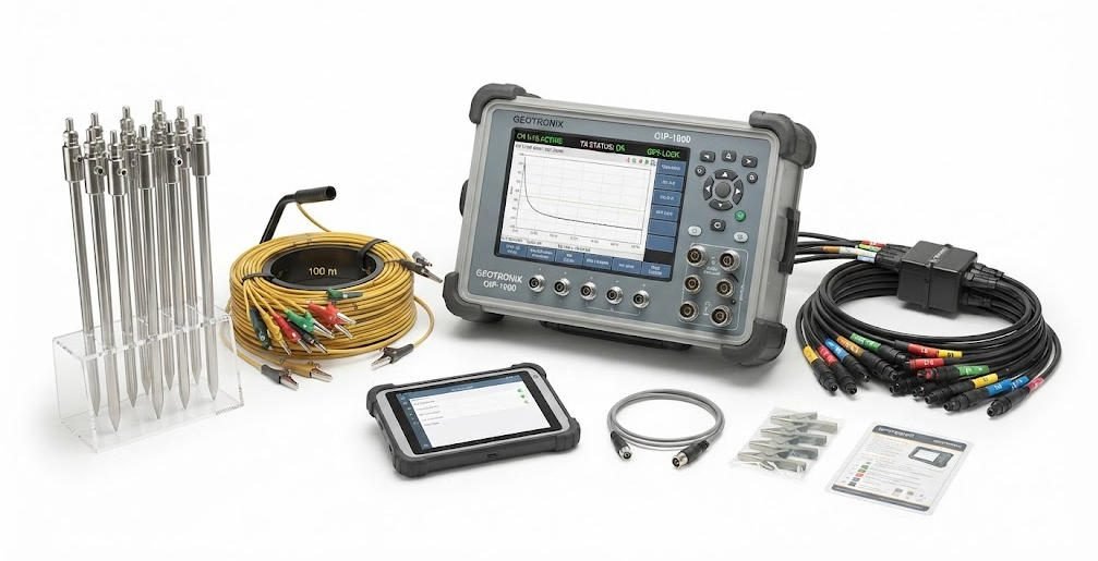
| Product Line | Key Technical Features | Primary Application Scenarios |
|---|---|---|
| GeoRes-IP Pro System | 256-channel synchronous acquisition, full-waveform recording | Deep metal ore modeling, large-scale regional exploration |
| HDR-IP360 System | Chargeability-resistivity dual imaging, 360-electrode switching | Groundwater contamination mapping, urban geotechnical surveys |
| SIP-3D Master System | 0.01Hz – 10kHz broadband excitation, spectral analysis | Mineralogical analysis, detailed ore body characterization |
| DJF Series High-Power IP | 5kW / 10kW digital DC output, deep penetration capability | Deep mineral exploration, thick overburden areas |
GeoRes-IP Pro is the flagship system for large-scale mineral exploration programs. 256-channel synchronous acquisition enables high-density 3D survey coverage. Full-waveform recording captures complete decay curves for advanced processing and analysis. The system is field-proven in major mining districts across Africa, Asia and South America.
HDR-IP360 combines high-density resistivity imaging with IP chargeability measurement. The integrated dual-parameter system delivers both structural and mineralogical data in one survey. 360-electrode intelligent switching provides flexible array configurations for different project needs. It is the preferred system for environmental and urban geotechnical applications.
SIP-3D Master delivers broadband spectral IP capability for advanced mineral identification. The system excites the subsurface across four decades of frequency from 0.01Hz to 10kHz. Spectral analysis algorithms identify specific mineral types based on relaxation time spectra. This technology enables direct mineralogical assessment from geophysical data alone.
DJF Series high-power transmitters deliver 5kW and 10kW output for deep IP surveys. Digital DC technology provides clean current waveforms with precise timing control. High power output extends investigation depth in resistive terrains and thick overburden areas. These systems are commonly used for deep base metal exploration in cratonic environments.
2. Key Technological Breakthroughs
Recent innovations have significantly improved IP method performance and application range. Three key technology trends are shaping the future of IP geophysics.
Full-waveform acquisition represents a major advance over traditional gated chargeability measurement. Older systems measured only a few discrete time gates on the decay curve. Modern systems sample the entire waveform at high resolution for detailed analysis. This approach provides more information for mineral discrimination and noise reduction.
AI-powered inversion dramatically reduces processing time and improves model quality. ConvIPNet deep learning algorithms produce geologically realistic 3D models in a fraction of the time. The technology removes bottlenecks that previously limited 3D IP survey scale. It also reduces interpretation bias through consistent automated processing.
Multi-method joint inversion combines IP data with resistivity, EM or magnetic data. Joint inversion leverages the strengths of each method to reduce interpretation ambiguity. IP-ERT joint inversion is particularly effective for karst detection and groundwater studies. This integrated approach delivers more accurate subsurface models than any single method alone.
Ⅴ. Field Deployment and Quality Control Protocols
1. Standard IP Survey Workflow
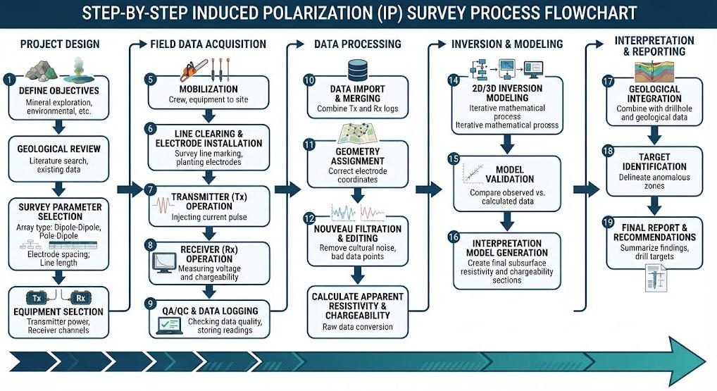
Successful IP surveys follow a structured workflow from planning through final interpretation. Adherence to standard procedures ensures data quality and reproducible results.
First, project design defines survey objectives, target depth and required resolution. Geophysicists select the appropriate IP variant and design electrode layout. Pilot tests verify system performance and method suitability in local geological conditions.
Second, field deployment involves electrode installation and equipment setup. Stainless steel electrodes are placed at precise intervals along survey lines. Transmitter and receiver units are connected and calibrated before data acquisition. Ground contact resistance is measured and optimized at each electrode station.
Third, data acquisition follows standardized operating parameters. Technicians set current intensity, pulse duration and sampling windows based on requirements. Each measurement is repeated multiple times for stacking and noise reduction. Field crews monitor data quality in real time and re-measure stations that fail quality checks.
Fourth, data processing applies filtering, correction and inversion algorithms. Processing removes cultural noise, electrode polarization effects and topographic distortion. Inversion algorithms convert raw field data into subsurface chargeability and resistivity models. Quality control checks verify inversion convergence and model plausibility.
Finally, geological interpretation integrates IP results with drilling and geological data. Experienced geophysicists identify and characterize subsurface anomalies. Final reports include interpretation maps, cross sections and uncertainty assessments. Recommendations for follow-up work and additional drilling are provided where appropriate.
2. Quality Assurance and Data Validation
Rigorous quality control is essential for reliable IP survey results. The following protocols ensure data accuracy and interpretation confidence.
Repeat measurements at 5–10% of stations provide quantitative assessment of data repeatability. Chargeability differences exceeding 2 mV/V trigger investigation and remeasurement. This practice identifies equipment drift, poor electrode contact and operator error.
Noise suppression techniques include stacking, digital filtering and time-window editing. Modern systems use adaptive filtering that automatically adjusts to local noise conditions. This maintains data quality even in areas with strong cultural electromagnetic interference.
Electrode polarization correction removes spurious signals from electrode-electrolyte interactions. This systematic error can produce false chargeability anomalies if not properly addressed. Calibration measurements quantify and remove this effect from survey data.
Borehole validation calibrates IP interpretations against direct downhole measurements. Where drilling data is available, inversion parameters are adjusted to match known geology. This calibration improves interpretation accuracy in surrounding unsurveyed areas.
Related Articles
| Title | Core Content | URL |
|---|---|---|
| Induced Polarization Method for Mineral Exploration | IP fundamentals, mineral exploration and chargeability | https://geotechcn.net/service/induced-polarization-1/ |
| IP Survey Systems: Revolutionizing Geophysical Exploration and Environmental Monitoring | TDIP, FDIP and IP survey systems | https://geotechcn.net/service/ip-survey-systems/ |
| What Is IP Imaging? | IP imaging, chargeability and resistivity integration | https://geotechcn.net/service/what-is-ip-imaging/ |
| Principles and Simulation Experiments of Potential Measurement Method | Electrical resistivity and IP fundamentals | https://geotechcn.net/service/electrical-methods/ |
| Resistivity Surveying Techniques | Resistivity, ERT and IP comparison | https://geotechcn.net/service/resistivity-surveying-techniques/ |
| High-Density Electrical Resistivity Method | High-density electrical acquisition and IP fundamentals | https://geotechcn.net/service/basic-principles-of-geophysical-exploration/ |
| Geophysical Exploration Classification | ERT/IP/electrical exploration method classification | https://geotechcn.net/service/geophysical-exploration-classification/ |
| What Is Electrical Resistivity Tomography? | ERT principles and electrical imaging | https://geotechcn.net/service/what-is-electrical-resistivity-tomography/ |
Reference Sources
| Title | Core Content | URL |
|---|---|---|
| US EPA — Induced Polarization (IP) and Complex Resistivity | IP Principles, TDIP, FDIP, SIP, Complex Resistivity, Applications and Limitations | http://www.epa.gov/environmental-geophysics/induced-polarization-ip-and-complex-resistivity |
| US EPA — Borehole Induced Polarization | Borehole IP, chargeability, and relationships involving minerals, pore fluids, and fluid-particle interfaces. | http://www.epa.gov/environmental-geophysics/borehole-induced-polarization |
| University of Kiel — Induced Polarization | Applications of IP, TDIP, FDIP, SIP, and Mineral/Hydrogeological Geophysics | https://www.appliedgeophysics.ifg.uni-kiel.de/de/methoden/induced-polarisation |
| Wiley — An Overview of the Spectral Induced Polarization Method | SIP theory, spectral measurement, modeling, and inversion | https://onlinelibrary.wiley.com/doi/10.3997/1873-0604.2012027 |
| Society of Exploration Geophysicists — Mineralogical and Textural Controls on SIP | Relationships of SIP with mineral composition, rock texture, and mineralization | https://doi.org/10.1190/geo2018-0404.1 |
FAQ
Q1: What is Induced Polarization (IP) method in geophysics?
IP is an active electrical geophysical method that measures subsurface chargeability by recording voltage decay after current injection. It detects electric double layer discharge at mineral-fluid interfaces. The method is widely used for sulfide mineral exploration and groundwater contamination assessment.
Q2: What is the maximum depth of time-domain IP surveys?
Time-domain IP typically achieves 50–800 meters depth depending on electrode spacing and transmitter power. Larger arrays and higher power extend depth in resistive terrains. It is the primary method for deep base metal exploration beneath thick overburden.
Q3: What is the main advantage of IP over standard resistivity methods?
IP provides dual-parameter chargeability data that enables mineral identification, while resistivity only measures conductivity. IP distinguishes sulfide minerals from other conductive targets like graphite or brine. This reduces exploration risk and improves drilling success rates.
Q4: Can IP methods detect groundwater contamination?
Yes, IP methods reliably detect and map groundwater contamination plumes with high sensitivity. Organic and ionic contaminants alter pore fluid chemistry and produce measurable polarization anomalies. Time-lapse IP monitors plume migration and remediation effectiveness over time.
Q5: How does AI improve 3D IP inversion processing?
AI algorithms like ConvIPNet accelerate 3D IP inversion from 2–8 hours to under 1.5 hours without accuracy loss. Deep learning models produce more geologically realistic subsurface models. This makes large-scale 3D IP surveys practical for time-critical exploration projects.